Sunnhordland
| Sunnhordland | |
|---|---|
| District | |
|
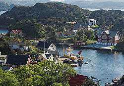
Espevær, Bømlo | |
 Hordaland county with Sunnhordland in blue | |
| Country | Norway |
| County | Hordaland |
| Region | Vestlandet |
| Adm. Center | Stord |
| Area | |
| • Total | 2,860 km2 (1,100 sq mi) |
| Population (2014) | |
| • Total | 58,680 |
| • Density | 21/km2 (53/sq mi) |
Sunnhordland is a traditional district in the Vestlandet region of Norway. The district consists of the southern coastal regions of Hordaland county. In includes the areas that surround the mouth of the Hardangerfjorden and the surrounding islands. The municipalities of Sveio, Etne, Stord, Bømlo, Fitjar, Kvinnherad, and Tysnes (and sometimes Austevoll) make up the district of Sunnhordaland. The regional centre of this district is the town of Leirvik in Stord.
In all, the district includes about 2,860 square kilometres (1,100 sq mi) of land. There were about 58,680 inhabitants in 2014, giving it a population density of about 20.5 inhabitants per square kilometre (53/sq mi). About 50% of the land area is mountainous land above 300 metres (980 ft) in elevation with most of the population living below that level in the valleys and coastal areas.[1]
Name
The name Sunnhordland is derived from "søndre Hordaland" which means "the southern part of Hordaland". It is similar in nature to the nearby districts of Nordhordland and Midhordland.
People from Sunnhordland are called Sunnhordlendinger and the people in this area speak a Norwegian dialect called Sunnhordlandsmål.
References
| Wikivoyage has a travel guide for Sunnhordland. |
- ↑ Store norske leksikon. "Sunnhordland – område" (in Norwegian). Retrieved 2015-02-05.