Sveio
| Sveio kommune | |||
|---|---|---|---|
| Municipality | |||
|
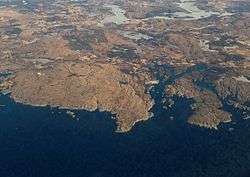
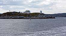
View of the Ryvarden coastline in Sveio | |||
| |||
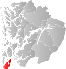 Sveio within Hordaland | |||
| Coordinates: 59°34′25″N 05°21′48″E / 59.57361°N 5.36333°ECoordinates: 59°34′25″N 05°21′48″E / 59.57361°N 5.36333°E | |||
| Country | Norway | ||
| County | Hordaland | ||
| District | Haugalandet | ||
| Administrative centre | Sveio | ||
| Government | |||
| • Mayor (2011) | Ruth Grethe Eriksen (H) | ||
| Area | |||
| • Total | 246.14 km2 (95.04 sq mi) | ||
| • Land | 224.25 km2 (86.58 sq mi) | ||
| • Water | 21.89 km2 (8.45 sq mi) | ||
| Area rank | 309 in Norway | ||
| Population (2015) | |||
| • Total | 5,509 | ||
| • Rank | 190 in Norway | ||
| • Density | 24.6/km2 (64/sq mi) | ||
| • Change (10 years) | 17.9 % | ||
| Demonym(s) | Sveibu[1] | ||
| Time zone | CET (UTC+1) | ||
| • Summer (DST) | CEST (UTC+2) | ||
| ISO 3166 code | NO-1216 | ||
| Official language form | Nynorsk | ||
| Website |
www | ||
|
| |||


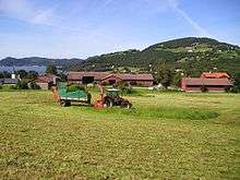
Sveio is a municipality in Hordaland county, Norway. Sveio is a border district that is sometimes considered to be located in the traditional district of Haugalandet since it is located on the Haugalandet peninsula, but it is also considered to be in the traditional district of Sunnhordland since it is located in southern Hordaland county.[2][3] The administrative centre of the municipality is the village of Sveio. Other villages in the municipality include Auklandshamn, Førde, Våga, and Valevåg.
Sveio is the site of the Ryvarden Lighthouse which marks the western entrance to the Hardangerfjorden. The lighthouse is automated and the old keepers house and building have now been converted into art galleries, the Flókemuseum, and a cafe.[4] The composer Fartein Valen lived much of his life in Valevåg in northern Sveio. Valenheimen, the house he lived in is open to the public and the Fartein Valen Festival is held annually in Sveio.
The Triangle Link bridge-tunnel network is based in northern Sveio, connecting the islands to the north to the mainland. The southern entrance to the Bømlafjord Tunnel is located along the European route E39 highway, just south of the village of Valevåg.
General information
The municipality of Sveio was established in 1865 when the part of Finnås municipality located south of the Bømlafjorden (population: 2,227) and the Vikebygd part of the municipality of Fjelberg (population: 1,062) were joined together as the new municipality of Sveen (later the spelling was changed to Sveio). On 1 January 1902, the Vikebygd area (population: 1,092) was separated from Sveio to form its own municipality. On 1 January 1964, there were some big municipal border changes in Norway due to the Schei Committee. Sveio (population: 1,697) was merged with the neighboring municipality of Valestrand (population: 1,216), the western half of the municipality of Vikebygd (population: 471), and a small part of the municipality of Skjold (population: 24). The part of Skjold was transferred from Rogaland county to Hordaland county on the same date.[5]
Name
The municipality (originally the parish) is named after the old Sveio farm (Old Norse: Sviða), since the first Sveio Church was built there in the Middle Ages. The name is identical with the word sviða which means a "clearing made by burning". Before 1912, the name was written Sveen.[6]
Coat-of-arms
The coat-of-arms is from modern times; they were granted on 19 February 1982. The arms show a white or silver fleur-de-lis on a red background. The arms are derived from the historic arms of Jon Gauteson from Sveio, who lived around the year 1500. His family became Norwegian nobility in 1591, and he was the first in his family to use this symbol as part of his arms.[7]
Churches
The Church of Norway has two parishes (sokn) within the municipality of Sveio. It is part of the Sunnhordland deanery in the Diocese of Bjørgvin.
| Parish (Sokn) | Church Name | Location of the Church | Year Built |
|---|---|---|---|
| Sveio | Sveio Church | Sveio | 1858 |
| Valestrand og Førde | Førde Church | Førde | 1938 |
| Valestrand Church | Valestrand | 1873 | |
| Valen Chapel | Valevåg | 1707 |
Geography
The municipality is located on the mainland of Norway on the western coast of the county on the Haugalandet peninsula, facing the North Sea to the west. The entrance to the Hardangerfjorden lies along the northern side of the municipality, and the smaller Ålfjorden lies along the eastern border of the municipality. Sveio's southern border is also the county border, bordering the town of Haugesund and the municipality of Tysvær to the south, the municipality of Vindafjord to the east (across the Ålfjorden), and the island municipalities of Bømlo and Stord to the north (across the Hardangerfjorden). The lakes Vigdarvatnet and Stakkastadvatnet lie in the southern part of the municipality, crossing into the neighboring municipalities. The Ryvarden Lighthouse is located on a small point, along the Hardangerfjorden.
| Historical population | ||
|---|---|---|
| Year | Pop. | ±% |
| 1951 | 1,954 | — |
| 1960 | 1,782 | −8.8% |
| 1970 | 3,477 | +95.1% |
| 1980 | 4,216 | +21.3% |
| 1990 | 4,582 | +8.7% |
| 2000 | 4,623 | +0.9% |
| 2010 | 4,999 | +8.1% |
| 2015 | 5,509 | +10.2% |
| Source: Statistics Norway. | ||
Government
All municipalities in Norway, including Sveio, are responsible for primary education (through 10th grade), outpatient health services, senior citizen services, unemployment and other social services, zoning, economic development, and municipal roads. The municipality is governed by a municipal council of elected representatives, which in turn elect a mayor.
Municipal council
The municipal council (Kommunestyre) of Sveio is made up of 25 representatives that are elected to every four years. For 2011–2015, the party breakdown is as follows:[8]
| Party Name | Name in Norwegian | Number of representatives | |
|---|---|---|---|
| Labour Party | Arbeiderpartiet | 5 | |
| Progress Party | Framstegspartiet | 5 | |
| Conservative Party | Høgre | 6 | |
| Christian Democratic Party | Kristelig Folkeparti | 4 | |
| Centre Party | Senterpartiet | 3 | |
| Liberal Party | Venstre | 1 | |
| Local Lists | Lokale lister | 1 | |
| Total number of members: | 25 | ||
Notable residents
- Grutle Kjellson, Musician
- Fartein Valen, Composer
- May Britt Vihovde, Politician and former Member of Parliament
- Einar Økland, Author and poet
- Cecilie Pedersen, Football player
References
- ↑ "Navn på steder og personer: Innbyggjarnamn" (in Norwegian). Språkrådet. Retrieved 2015-12-01.
- ↑ Store norske leksikon. "Sunnhordland – område" (in Norwegian). Retrieved 2015-03-11.
- ↑ Store norske leksikon. "Sveio" (in Norwegian). Retrieved 2015-03-11.
- ↑ "Ryvarden Lighthouse". Samarbeidsrådet for Sunnhordland.
- ↑ Jukvam, Dag (1999). "Historisk oversikt over endringer i kommune- og fylkesinndelingen" (PDF) (in Norwegian). Statistisk sentralbyrå.
- ↑ Rygh, Oluf (1910). Norske gaardnavne: Søndre Bergenhus amt (in Norwegian) (11 ed.). Kristiania, Norge: W. C. Fabritius & sønners bogtrikkeri. p. 106.
- ↑ "Civic heraldry of Norway - Norske Kommunevåpen". Heraldry of the World. Retrieved 2015-03-11.
- ↑ "Members of the local councils, by party/electoral lists and municipality" (in Norwegian). Statistics Norway. 2011.