Sutherland, Utah
| Sutherland | |
|---|---|
| CDP | |
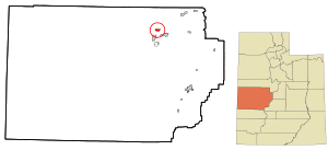 Location in Millard County and the state of Utah. | |
| Coordinates: 39°23′22″N 112°38′24″W / 39.38944°N 112.64000°WCoordinates: 39°23′22″N 112°38′24″W / 39.38944°N 112.64000°W | |
| Country | United States |
| State | Utah |
| County | Millard |
| Founded | 1909 |
| Founded by | Myron Abbott |
| Named for | George Sutherland |
| Area[1] | |
| • Total | 2.2 sq mi (6 km2) |
| • Land | 2.2 sq mi (6 km2) |
| • Water | 0.0 sq mi (0 km2) |
| Elevation[2] | 4,626 ft (1,410 m) |
| Population (2010)[3] | |
| • Total | 165 |
| • Density | 75/sq mi (29/km2) |
| Time zone | Mountain (MST) (UTC-7) |
| • Summer (DST) | MDT (UTC-6) |
| ZIP codes | 84624 |
| Area code(s) | 435 |
| GNIS feature ID | 2584778[2] |
Sutherland is a census-designated place in Millard County, Utah, United States. The population was 165 at the 2010 census.
Geography
Sutherland is located in the north central part of Millard County, some 4 miles (6.4 km) northwest of the city of Delta[4] across the Sevier River. Hinckley lies about 6 miles (9.7 km) to the southwest, and Gunnison Bend Reservoir is 5 miles (8.0 km) south. Sutherland is one of a number of small farming communities in the area, including Woodrow and Sugarville just to the north. About 9 miles (14 km) to the west is the site of the historic Topaz War Relocation Center.
History
In 1909, a tract of thousands of acres of land northwest of the new city of Delta became available for agricultural settlement, under the terms of the Carey Act. Settlers began to cluster around the property of Myron Abbott, regarded as founder of the community,[5]:211 which was known early on as North Tract or West Delta. By 1912, there were 80 families with 121 children of school age in the area. Tired of waiting for county officials, private citizens built a public schoolhouse in 1913. Then residents petitioned for the creation of a voting precinct and school district. The name Sutherland was chosen in honor of Utah political figure George Sutherland, who was serving as a United States Senator at the time.[5]:228 The Sutherland elementary school remained open until the 1970s.[5]:389–390
Demographics
| Historical population | |||
|---|---|---|---|
| Census | Pop. | %± | |
| 1920 | 446 | — | |
| 1930 | 438 | −1.8% | |
| 1940 | 507 | 15.8% | |
| 1950 | 428 | −15.6% | |
| 2010 | 165 | — | |
| Source: U.S. Census Bureau[6] | |||
As of the census[3] of 2010, there were 165 people residing in the CDP. There were 53 housing units. The racial makeup was 95.8% White, 3.0% from some other race, and 1.2% from two or more races. Hispanic or Latino of any race were 6.1% of the population.
Notable people
- Carlos E. Asay—Member of the First Quorum of the Seventy of the LDS Church, born in Sutherland
References
- ↑ "2010 Census U.S. Gazetteer File for Places: Utah". Retrieved October 23, 2012.
- 1 2 U.S. Geological Survey Geographic Names Information System: Oasis. Retrieved October 23, 2012.
- 1 2 "American FactFinder". United States Census Bureau. Retrieved November 9, 2012.
- ↑ Van Cott, John W. (1990). Utah Place Names. Salt Lake City: University of Utah Press. p. 359. ISBN 0-87480-345-4.
- 1 2 3 Lyman, Edward Leo; Newell, Linda King (January 1999). A History of Millard County (PDF). Utah Centennial County History Series. Salt Lake City: Utah State Historical Society. ISBN 0-913738-38-7. Retrieved July 16, 2012.
- ↑ "Census of Population and Housing". U.S. Census Bureau. Retrieved November 18, 2011.
Municipalities and communities of Millard County, Utah, United States | ||
|---|---|---|
| Cities | 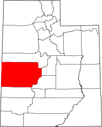 | |
| Towns | ||
| CDPs | ||
| Unincorporated communities | ||
| Ghost towns | ||