Sutton, Quebec
| Sutton | |
|---|---|
| City | |
|
Main Street (Quebec Route 139) | |
 Location within Brome-Missisquoi RCM. | |
 Sutton Location in southern Quebec. | |
| Coordinates: 45°06′N 72°37′W / 45.100°N 72.617°WCoordinates: 45°06′N 72°37′W / 45.100°N 72.617°W[1] | |
| Country |
|
| Province |
|
| Region | Montérégie |
| RCM | Brome-Missisquoi |
| Settled | 1802 |
| Constituted | July 4, 2002 |
| Government[2][3] | |
| • Mayor | Louis Dandenault |
| • Federal riding | Brome—Missisquoi |
| • Prov. riding | Brome-Missisquoi |
| Area[2][4] | |
| • Total | 248.50 km2 (95.95 sq mi) |
| • Land | 246.54 km2 (95.19 sq mi) |
| Population (2011)[4] | |
| • Total | 3,906 |
| • Density | 15.8/km2 (41/sq mi) |
| • Pop 2006-2011 |
|
| • Dwellings | 3,507 |
| Time zone | EST (UTC−5) |
| • Summer (DST) | EDT (UTC−4) |
| Postal code(s) | J0E 2K0 |
| Area code(s) | 450 and 579 |
| Highways |
|
| Website |
www |
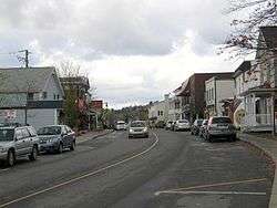
Sutton is a town situated in southwestern Quebec. It is part of the Brome-Missisquoi Regional County Municipality in the administrative region of the Montérégie. The population as of the Canada 2011 Census was 3,906. Historically, Sutton is considered to be part of the Eastern Townships.
History
Like many other towns and villages in the Eastern Townships, Sutton became home to many loyalists, following the American Revolution. In 1799 the first recorded loyalists immigrated to the area, among them Richard Shepherd, originally of New Hampshire. During the 19th century, new buildings were erected to serve the town's growing population, among them a school in 1808 (located on the road linking the town to nearby Abercorn) as well as the town hall built in 1859. In the decades that followed, Protestant and Roman Catholic churches were built as well as a railway station.[5]
Sutton officially became a municipality in 1892, and later a town in 1962. In 2002, the township of Sutton merged with the town of Sutton,[6] roughly doubling the town's population, and vastly expanding the town's area. The economy has moved from one largely based on farming to one that is heavily reliant on tourism due to the opening of SUTTON ski resort in 1960. More recently Sutton has also become a popular destination for road biking, hiking and visits to vineyards making it an all-year tourist destination.
Geography
Sutton is located on the Canada–United States border with Vermont, 110 kilometres (68 mi) southeast of Montreal, 400 kilometres (250 mi) northwest of Boston, Massachusetts and 90 kilometres (56 mi) west of Sherbrooke.
Sutton is also situated in close proximity to Mont Sutton, which has an altitude of 968 metres (3,176 ft), and is a popular Ski resort for tourists.[7]
Demographics
Population
According to 2011 Census data, Sutton has one of the highest median ages in Canada, at 54.8 years. A sizable percentage of the town's population is composed of artists, the highest proportion in Canada.[8]
| Canada census – Sutton, Quebec community profile | |||
|---|---|---|---|
| 2011 | 2006 | 2001 | |
| Population: | 3,906 (+2.7% from 2006) | 3,805 (+8.0% from 2001) | 1,631 (+0.9% from 1996) |
| Land area: | 246.54 km2 (95.19 sq mi) | 246.51 km2 (95.18 sq mi) | 8.79 km2 (3.39 sq mi) |
| Population density: | 15.8/km2 (41/sq mi) | 15.4/km2 (40/sq mi) | 185.6/km2 (481/sq mi) |
| Median age: | 54.8 (M: 54.9, F: 54.7) | 51.1 (M: 51.4, F: 50.7) | 46.7 (M: 44.9, F: 47.7) |
| Total private dwellings: | 3,507 | 3,319 | 907 |
| Median household income: | $48,453 | $45,341 | $26,289 |
| References: 2011[4] 2006[9] 2001[10] | |||
| Historical Census Data - Sutton, Quebec[11] | |||||||||||||||||||||||||||||
|---|---|---|---|---|---|---|---|---|---|---|---|---|---|---|---|---|---|---|---|---|---|---|---|---|---|---|---|---|---|
|
|
| |||||||||||||||||||||||||||
(M) merger with township of Sutton in 2002. | |||||||||||||||||||||||||||||
Language
| Canada Census Mother Tongue - Sutton, Quebec[11] | ||||||||||||||||||
|---|---|---|---|---|---|---|---|---|---|---|---|---|---|---|---|---|---|---|
| Census | Total | French |
English |
French & English |
Other | |||||||||||||
| Year | Responses | Count | Trend | Pop % | Count | Trend | Pop % | Count | Trend | Pop % | Count | Trend | Pop % | |||||
| 2011 |
3,815 |
2,295 | |
60.16% | 1,255 | |
32.90% | 75 | |
1.97% | 190 | |
4.98% | |||||
| 2006 |
3,735 |
2,340 | |
62.65% | 1,160 | |
31.06% | 70 | |
1.87% | 165 | |
4.42% | |||||
| 2001 |
1,560 |
765 | |
49.04% | 725 | |
46.47% | 30 | |
1.92% | 40 | |
2.56% | |||||
| 1996 |
1,540 |
735 | n/a | 47.73% | 680 | n/a | 44.16% | 75 | n/a | 4.87% | 50 | n/a | 3.25% | |||||
Much like many other communities in the southwestern quadrant of the province, Sutton has historically been an anglophone enclave in a predominantly francophone province. Today anglophones make up only 33% of the population, compared to 60% for francophones and 5% for allophones.
Due to a large amount of Swiss people in the town, Sutton has many people who speak German. Every year Swiss National Day is celebrated at Mont Sutton ski resort on the last Saturday in July.
See also
References
- ↑ Reference number 61208 of the Commission de toponymie du Québec (French)
- 1 2 Ministère des Affaires municipales, des Régions et de l'Occupation du territoire: Sutton
- ↑ Parliament of Canada Federal Riding History: BROME--MISSISQUOI (Quebec)
- 1 2 3 2011 Statistics Canada Census Profile: Sutton, Quebec
- ↑ "Sutton". Eastern Townships, Quebec. 2005. Retrieved 2008-06-02.
- ↑ http://www.stat.gouv.qc.ca/publications/referenc/pdf/modjuillet02.pdf
- ↑ "All about us - Presentation". Mount Sutton. Retrieved 2008-06-02.
- ↑ Foulds, Diane E. (September 2, 2007). "Quebec town makes the arts a tie that binds". The Boston Globe. Retrieved 2008-06-02.
- ↑ "2006 Community Profiles". Canada 2006 Census. Statistics Canada. March 30, 2011. Retrieved 2014-03-13.
- ↑ "2001 Community Profiles". Canada 2001 Census. Statistics Canada. February 17, 2012. Retrieved 2014-03-13.
- 1 2 Statistics Canada: 1996, 2001, 2006, 2011 census
External links
 |
Dunham | Brome Lake Brome |
West Bolton | |
| Frelighsburg | |
Potton | ||
| ||||
| | ||||
| Abercorn | |
| Cities & Towns |
|
|---|---|
| Municipalities | |
| Townships | |
| Villages | |
| |
| |
| Quebec City area: | |
| Montreal local area: |
|
| Montreal-area Laurentians: | |
| Eastern Townships: | |
| Gatineau area |
|
| Saguenay–Lac-Saint-Jean | |
| |