Swallow Reef
| Disputed island Other names: Danwan Jiao 弹丸礁; (Chinese) Pulau Layang-Layang (Malay) Celerio; (Filipino) Đá Hoa Lau (Vietnamese) | |
|---|---|
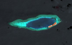 | |
| Satellite image of Swallow Reef by NASA. | |
| Geography | |
 Swallow Reef (South China Sea) | |
| Location | South China Sea |
| Coordinates | 7°22′20″N 113°50′30″E / 7.37222°N 113.84167°ECoordinates: 7°22′20″N 113°50′30″E / 7.37222°N 113.84167°E |
| Archipelago | Spratly Islands |
| Area | 35 hectares (86 acres) |
| Administered by | |
| Malaysia | |
| State | Sabah |
| Claimed by | |
| People's Republic of China | |
| City | Sansha, Hainan |
| Republic of China (Taiwan) | |
| Municipality | Cijin, Kaohsiung |
| Vietnam | |
| District | Truong Sa, Khanh Hoa |
| Additional information | |
| Malaysian population: 70[1]
Malaysian postal code: 88005[2] | |
Swallow Reef, known as Pulau Layang-Layang (Malay and Dusun for Island of Swallows) in Malaysia, Danwan Jiao (Chinese: 弹丸礁) in China, Celerio in the Philippines and Đá Hoa Lau in Vietnam, is an oceanic atoll of the Spratly Islands administered by Malaysia which is situated approximately 300 km northwest of Kota Kinabalu, Sabah. Swallow Reef had an original land area of approximately 6.2 hectares (15 acres), but with reclaimed land now covers 35 hectares (86 acres),[3] measuring over 1.5 kilometres (0.93 mi) long and 200 m (656 ft) wide.[4]
The Royal Malaysian Navy (RMN) has maintained a presence on the reef since 1983, but as with all of the Spratly Islands, the ownership is disputed, and it is also claimed by the People's Republic of China, the Republic of China (Taiwan) and Vietnam. The Philippines does not lay claim to Swallow Reef.[5]
The island's air transport needs are served by the Layang-Layang Airport.
History
| Part of a series on the |
| Spratly Islands |
|---|
 Spratly Islands military occupations map |
| Related articles |
| Confrontations |
| Military occupations |
|
|
On 21 June 1980, a claim plaque was erected on the reef by Malaysia's PASKAL special forces.[6]
In May 1983, eighteen PASKAL members built their first encampment, signifying the start of the Royal Malaysian Navy's presence. At the time, the only infrastructure available was a helipad for personnel transfer, and the special forces had to camp under the open skies on the bare reef. Naval Station "Lima" was constructed in April 1986, consisting of a small living-cum-operations centre.
In 1989, the government decided to develop the island into a tourist spot.[4]
By 1991, the resort had completed construction and had developed into a comfortable and popular diving spot.[6][7]
By 1995, more buildings were added, including two air-conditioned accommodation blocks, an aircraft landing strip, two hangars, a radar station, an air traffic control tower, watchtowers and a jetty.
On 20 July 2003, the Layang-Layang Airport expansion which increased the length of the runway from 1,064 metres (3,490 ft) to 1,367 metres (4,480 ft) was completed. As a result, the length of the island increased from 1.2 kilometres to over 1.5 kilometres.[4]
In July 2004, a marine research facility, MARSAL (Marine Research Station Pulau Layang-Layang) was opened.[7]
On 5 March 2009, Abdullah Ahmad Badawi, the Malaysian Prime Minister of the time, visited the island.[8]
Facilities
Layang-Layang Airport
The airport consists of a paved aircraft runway, two aircraft hangars, a radar station, an air traffic control tower and watchtowers. The runway, made of concrete, is 1367m long and 28m wide.[4] The runway has a Pavement Classification Number of 032RBXU, indicating that the runway is a medium strength rigid pavement, with a high maximum tire pressure.[9][10]
The aviation facilities on the island allow the operation of C130 Hercules transport planes and CN-235 maritime patrol aircraft of the Royal Malaysian Air Force (RMAF). Layang Layang Aerospace offers flights for civilians to and from the airport.
Avillion Layang-Layang Resort
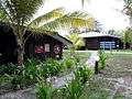
Avillion Layang-Layang is a 3 star island resort located on the island. It has 76 superior rooms and 10 deluxe rooms; all rooms are made of tropical hardwood. It shares the look of a Longhouse, the traditional community homes of Borneo’s tribal people. Each room has 2 queen sized beds, individually controlled air-conditioning, attached bathroom with hot/cold water shower, private balcony, television with in-house videos and programmes from regional satellite broadcast, and telephone facilities. The resort's restaurant serves Asian and Western Cuisine and also has a lounge bar. There are also fresh water swimming pools and international phone and fax services. There is also a body massage and foot reflexology centre called Raba Raba House.[11]
Naval Station Lima

The Royal Malaysian Navy has maintained a naval station on the island since 1983, and CB90 assault craft based in the station patrol the surrounding waters. Several anti-ship and anti-aircraft guns are placed around the reef, and the personnel operate a Starburst air defence system to prevent low level attacks on the island.[6]
The jetty is located inside the lagoon of the submerged atoll, and has access to the sea through a man-made path cleared of corals.
The naval personnel are normally stationed on the island on a three-month rotational deployment, transferring from Kota Kinabalu, where the Naval Area Base II (Mawila II) is located.[12]
Marine Research Station
The Malaysian Fisheries department operates a marine research facility, MARSAL (Marine Research Station Pulau Layang-Layang) on the island.
Utilities
Electricity
The main power source of the island comes from diesel generators. On the naval station, there is a large windmill maintained by state-owned power company Tenaga Nasional which harnesses power from wind speeds of up to 50 knots to provide additional electricity supply to the base.[12]
Water
The island's clean water supply of 57 tons per day is obtained from a distilled water processing plant.[4]
Post service
In 2015, Malaysia launched a postcode for those living in the island.[2]
Internet and mobile cellular connectivities
Internet services are currently been improved and mobile connectivities will be improved from 2G to 3G by Malaysian Communications and Multimedia Commission.[13]
Climate
Swallow Reef is located within the equatorial belt and has an equatorial climate. It is closed to tourists from November to January each year due to heavy monsoon rains, however, Malaysian Armed Forces personnel operate on the island year-long. Temperatures range from 24 to 32 °C. Although an equatorial climate comes with fairly high humidity, there are cooling sea breezes.
Accessibility
The only civilian flight route to Swallow Reef is a one-hour flight from Sabah's capital Kota Kinabalu. Layang Layang Aerospace is the only airline that services this route, using its fleet of Nomad N22C planes. A return ticket must be purchased before departure from Kota Kinabalu International Airport.
The Royal Malaysian Navy uses CB90 boats for access to the area and also stations the boats on the island for patrols in the area. The Royal Malaysian Air Force uses CN235 and C130 Hercules aircraft as well as Nuri helicopters for access to the island.
See also
Gallery
 The island
 The island
 The airstrip
- The resort
 The resort
- The wharf


References
- ↑ http://www.malaysiasite.nl/layangeng.htm
- 1 2 "Deepest Underwater Post Box Launched At Pulau Layang-layang". Bernama. 7 August 2015. Archived from the original on 9 August 2015. Retrieved 9 August 2015.
- ↑ "WantChinaTimes(Taiwan)". Retrieved 16 March 2015.
- 1 2 3 4 5 "History of Station Lima at Swallow Reef (Terumbu Layang-Layang)". Konflikdanmiliter. Blogspot. 8 September 2014. Retrieved 15 March 2015.
- ↑ The Philippines does not lay claim to Swallow Reef; it is outside of the Kalayaan Island Group which was defined by Presidential Decree No. 1596 signed by Ferdinand Marcos - "Philippine Presidential Decree No. 1596" (PDF). Retrieved 31 August 2012.
- 1 2 3 This blog contains a useful summary of the history of the Malaysian settlements in the Spratly Islands. It expands on the basic facts provided in the Mohd Nizam Basiron chapter (Ref 4), filling in some of the gaps.
(Note: A blog is NOT a WP:RS - hence the "citation needed" tag - but until a RS is identified, it's better than nothing.) - 1 2 Mohd Nizam Basiron (15 February 2013). "5". In Joshua Ho; Sam Bateman. The search for sustainability and security : Malaysia's maritime challenges and opportunities. Maritime Challenges and Priorities in Asia: Implications for Regional Security. Routledge. pp. 73–75. ISBN 978-1-136-29820-2.
- ↑ "Taiwan Ministry of Foreign Affairs". Retrieved 16 March 2015.
- ↑ "AirportsWorldwide". Retrieved 15 March 2015.
- ↑ See Swallow Reef for more information.
- ↑ "JourneyMalaysia". Retrieved 15 March 2015.
- ↑ "SKMM naik taraf internet di Pulau Layang-layang" (in Malay). Sinar Harian. 7 August 2015. Retrieved 9 August 2015.
External links
-
 Layang Layang travel guide from Wikivoyage
| Bays | |
|---|---|
| Capes | |
| Rivers |
|
| Mountains and Mountain ranges | |
| Peninsula |
|
| Waterfall | |
| Valley | |
| Caves | |
| Volcanic field | |
| Islands |
|
| Other areas | |
| Dispute | |