Investigator Shoal
| Disputed island Other names: Yuya Ansha 榆亚暗沙; Terumbu Peninjau; Pawikan | |
|---|---|
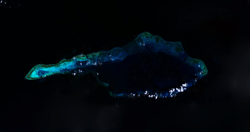 | |
| Satellite image of Investigator Shoal by NASA. | |
| Geography | |
 Investigator Shoal (South China Sea) | |
| Location | South China Sea |
| Coordinates | 8°6′51″N 114°42′7″E / 8.11417°N 114.70194°ECoordinates: 8°6′51″N 114°42′7″E / 8.11417°N 114.70194°E |
| Archipelago | Spratly Islands |
| Administered by | |
| Malaysia | |
| Claimed by | |
| People's Republic of China | |
| City | Sansha, Hainan |
| Philippines | |
| Municipality | Kalayaan, Palawan |
| Republic of China (Taiwan) | |
| Municipality | Cijin, Kaohsiung |
| Vietnam | |
| District | Truong Sa, Khanh Hoa |
Not to be confused with North East Investigator Shoal in the Spratly group.
Investigator Shoal, known as Yuya Ansha (Chinese: 榆亚暗沙) in China, Terumbu Peninjau in Malaysia, Pawikan in the Philippines, and bãi Thám hiểm in Vietnam is an atoll above water at low tide; some large rocks at the western end might be visible at high water. The atoll has a total length of 32.1 km, and is up to 10.6 km wide.[1] The total area of the atoll is 188 km². The lagoon is up to 45 meters deep.[2]
The Royal Malaysian Navy has maintained a naval station called "Papa Station" since 1999.[3]
References
- ↑ measured from the satellite image with the measuring tool at Wikimapia
- ↑ Atoll Area, Depth and Rainfall
- ↑ Joshua Ho; Sam Bateman (15 February 2013). Maritime Challenges and Priorities in Asia: Implications for Regional Security. Routledge. pp. 74–. ISBN 978-1-136-29820-2.
| Bays | |
|---|---|
| Capes | |
| Rivers |
|
| Mountains and Mountain ranges | |
| Peninsula |
|
| Waterfall | |
| Valley | |
| Caves | |
| Volcanic field | |
| Islands |
|
| Other areas | |
| Dispute | |
This article is issued from Wikipedia - version of the 11/2/2016. The text is available under the Creative Commons Attribution/Share Alike but additional terms may apply for the media files.