Sylamore Scenic Byway
| |
|---|---|
|
Sylamore Scenic Byway highlighted in red | |
| Route information | |
| Length: | 26.5 mi[1] (42.6 km) |
| Existed: | February 8, 1989[2] – present |
| Major junctions | |
| North end: |
|
| South end: |
|
| Highway system | |


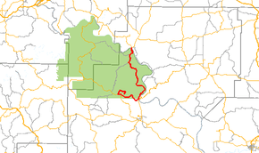
The Sylamore Scenic Byway is one of ten Arkansas Scenic Byways. The route runs through the Ozark-St. Francis National Forest in Arkansas for 26.5 miles (42.6 km), almost all in Stone County.[1] It passes through undeveloped forest land as a scenic route to Blanchard Springs Caverns.
Route description
The route begins at Calico Rock and runs south along Arkansas Highway 5. AR 5 meets AR 14 in Sylamore, and the byway follows AR 14 into the Ozark-St. Francis National Forest. The route continues as Forest Service Road 1110 to the Blanchard Springs Caverns, where it terminates.
History
The Sylamore Scenic Byway was designated National Forest Scenic Byway on February 8, 1989.[2]
See also
-
 Arkansas portal
 -
 U.S. Roads portal
 - List of Arkansas state highways
References
- 1 2 Stone County (PDF) (Map). Arkansas State Highway and Transportation Department. Retrieved August 27, 2009.
- 1 2 Staff. "Official Designations". Sylamore Scenic Byway. Federal Highway Administration.
External links
-
 Media related to Sylamore Scenic Byway at Wikimedia Commons
This article is issued from Wikipedia - version of the 11/3/2015. The text is available under the Creative Commons Attribution/Share Alike but additional terms may apply for the media files.