Tabler, Oklahoma
| Tabler | |
|---|---|
| Unincorporated community | |
 Tabler  Tabler Location within the state of Oklahoma | |
| Coordinates: 35°02′39″N 97°49′11″W / 35.04417°N 97.81972°WCoordinates: 35°02′39″N 97°49′11″W / 35.04417°N 97.81972°W | |
| Country | United States |
| State | Oklahoma |
| County | Grady |
| Time zone | Central (CST) (UTC-6) |
| • Summer (DST) | CDT (UTC-5) |
| GNIS feature ID | 11008711825323 |
Tabler is an unincorporated community in eastern Grady County, Oklahoma.[1] It is located at the western end of State Highway 39, where it meets U.S. Highway 62/277/SH-9.
Notable citizens
- Shug Fisher - actor, comedian, singer, songwriter, musician
References
Municipalities and communities of Grady County, Oklahoma, United States | ||
|---|---|---|
| Cities | 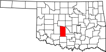 | |
| Towns |
| |
| Unincorporated communities |
| |
| Ghost towns | ||
| Footnotes | ‡This populated place also has portions in an adjacent county or counties | |
This article is issued from Wikipedia - version of the 7/31/2016. The text is available under the Creative Commons Attribution/Share Alike but additional terms may apply for the media files.