Tarn (river)
| Tarn | |
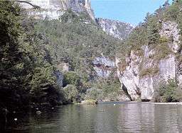 High cliffs in the Gorges du Tarn | |
| Country | France |
|---|---|
| Landmark | Gorges du Tarn |
| Source | Mont Lozère |
| - location | Cévennes, France |
| - elevation | 1,550 m (5,085 ft) |
| - coordinates | 44°24′53″N 3°48′54″E / 44.41472°N 3.81500°E |
| Mouth | Garonne |
| - location | Moissac, France |
| - coordinates | 44°05′10″N 1°02′33″E / 44.086111°N 1.0425°ECoordinates: 44°05′10″N 1°02′33″E / 44.086111°N 1.0425°E |
| Length | 381 km (237 mi) |
| Basin | 15,700 km2 (6,062 sq mi) |
| Discharge | |
| - average | 140 m3/s (4,944 cu ft/s) |
| Progression | Garonne→ Atlantic Ocean |
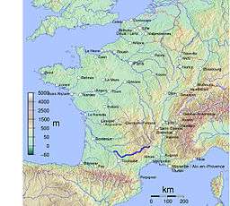 Tarn within France | |
| Wikimedia Commons: Tarn River | |
The Tarn (Occitan: Tarn, Latin: Tarnis, possibly meaning 'rapid' or 'walled in') is a 381-kilometre (237 mi) long river in southern France (régions Languedoc-Roussillon and Midi-Pyrénées), right tributary of the Garonne.
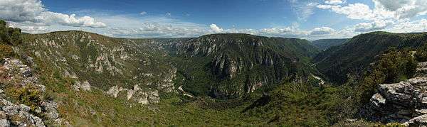
The Tarn runs in a roughly westerly direction, from its source at an elevation of 1,550 m (5,085 ft) on Mont Lozère in the Cévennes mountains (part of the Massif Central), through the deep gorges and canyons of the Gorges du Tarn (that cuts through the Causse du Larzac), to Moissac in Tarn-et-Garonne, where it joins the Garonne 4 km (2.5 mi) downstream from the centre of town.
Its basin covers approximately 12,000 square kilometres (4,600 sq mi), and it has a mean flow of approximately 140 cubic metres per second (4,900 cu ft/s).
The Millau Viaduct spans the valley of the River Tarn near Millau, and is now one of the area's most popular attractions.
Main tributaries
The tributaries of the Tarn include:
- Agout (in Saint-Sulpice)
- Alrance
- Aveyron (near Montauban)
- Cernon
- Dourbie (in Millau)
- Dourdou de Camarès
- Jonte (in Le Rozier)
- Lemboulas
- Lumensonesque
- Muze
- Rance (near Trébas)
- Tarnon (in Florac)
- Tescou
The Tarn separates the Narbonne and Aquitaine basins.
Departments and cities
The Tarn passes through the following departments and towns:
- Lozère: Le Pont-de-Montvert, Sainte-Enimie
- Aveyron: Millau
- Tarn: Albi, Gaillac, Lisle-sur-Tarn, Rabastens
- Haute-Garonne: Villemur-sur-Tarn
- Tarn-et-Garonne: Montauban, Moissac.
The Millau Viaduct, the tallest bridge in the world, carrying the A75 autoroute across the Tarn Gorge near Millau, opened in December 2004.
The Tarn is famous for its brutal floodings, which are the most dangerous in Europe along with the Danube River. The flooding of March 1930 saw the Tarn rise more than 17 metres (56 ft) above its normal level in Montauban in just 24 hours, with a discharge of 7,000 m³/s (average discharge of Rhine is 2,200 m³/s; average discharge of Nile River during the traditional annual flooding before the building of the Aswan Dam was 8,500 m³/s; average discharge of the Mississippi River is 16,200 m³/s). One third of the Tarn-et-Garonne département was flooded, about 300 people died, thousands of houses were destroyed, the low districts of Montauban were destroyed, the town of Moissac was almost entirely destroyed.
Navigation
The Tarn was once navigable from its junction with the Garonne to Corbarieu, near Montauban. This stretch of river included seven river locks over a distance of 38 kilometres (24 mi). The canal was linked to the Canal de Garonne in Moissac by a branch lock upstream of the first river lock, and again, via the Canal de Montech, at Montauban.[1]
The two access points from the Canal de Garonne have both been restored, and boats can again access the immediate reaches of the river at these points. Additionally the first river lock, between Moissac and the Garonne itself, has been flooded by the barrage for the Golfech power station on the Garonne, and is permanently open to boats which can thus reach the Garonne and navigate a short distance of that river.[1]
The remaining six river locks are disused and unnavigable. A proposal exists to restore the five river locks between Moissac and Montauban, thus creating a waterway ring consisting of the Tarn from Moissac to Montauban, the Canal de Montech to Montech and the Canal de Garonne back to Moissac.[1]
See also
References
Specific
- 1 2 3 "River Tarn (and the Tarn 'Ring')". grehanman guides. Retrieved 2010-11-22.
General
External links
| Wikimedia Commons has media related to Tarn River. |
- French Waterways - River Tarn Navigation guide to the lower 40 km.
- http://www.gorgesdutarn.net/?lang=en