Tarn-et-Garonne
| Tarn-et-Garonne | |||
|---|---|---|---|
| Department | |||
|
Prefecture building of the Tarn-et-Garonne department, in Montauban | |||
| |||
 Location of Tarn-et-Garonne in France | |||
| Coordinates: 44°0′N 1°20′E / 44.000°N 1.333°ECoordinates: 44°0′N 1°20′E / 44.000°N 1.333°E | |||
| Country | France | ||
| Region | Occitanie | ||
| Prefecture | Montauban | ||
| Subprefectures | Castelsarrasin | ||
| Government | |||
| • President of the General Council | Jean-Michel Baylet | ||
| Area1 | |||
| • Total | 3,718 km2 (1,436 sq mi) | ||
| Population (2013) | |||
| • Total | 250,342 | ||
| • Rank | 80th | ||
| • Density | 67/km2 (170/sq mi) | ||
| Time zone | CET (UTC+1) | ||
| • Summer (DST) | CEST (UTC+2) | ||
| Department number | 82 | ||
| Arrondissements | 2 | ||
| Cantons | 30 | ||
| Communes | 195 | ||
| ^1 French Land Register data, which exclude estuaries, and lakes, ponds, and glaciers larger than 1 km2 | |||
.jpg)

Tarn-et-Garonne (French pronunciation: [taʁn‿e ɡa.ʁɔn], Occitan: Tarn e Garona) is a department in the southwest of France. It is traversed by the Rivers Tarn and Garonne, from which it takes its name. This area was originally part of the former provinces of Quercy and Languedoc. The department was created in 1808 by Napoléon Bonaparte, with territory being taken from the departments of Lot, Haute-Garonne, Lot-et-Garonne, Gers and Aveyron. The department is mostly rural with fertile agricultural land in the broad river valley, but there are hilly areas to the south, east and north. The departmental prefecture is Montauban, and some of the other large communes include Castelsarrasin, Molières, Caussade, Valence-d'Agen and the medieval town of Lauzerte.
History
History of the region
Quercy was part of Aquitania prima under the Romans, and Christianity was introduced during the 4th century. Early in the 6th century the area fell under the authority of the Franks, and in the 7th century became part of the autonomous Duchy of Aquitaine. At the end of the 10th century its rulers were the powerful counts of Toulouse. During the hostilities between England and France in the reign of Henry II of England, the English placed garrisons in the county, and by the 1259 Treaty of Paris lower Quercy came under the control of England.[1] The kings of both England and France around this time tried to curry favour by adding to the privileges of the towns and the district. In 1360, the Treaty of Brétigny was signed and the whole of Quercy passed to England. However, in the 1440s the English were finally expelled by the newly created army of Charles VII of France.[2] In the 16th century Quercy was a stronghold of the Protestants, and the scene of fierce religious conflicts. The civil wars of the reign of Louis XIII largely took place around Montauban.
After Napoleon's defeat in 1815, the monarchy was re-established in France, but the discredited Bourbon Dynasty was overthrown in the July Revolution of 1830, which established the constitutional July Monarchy, which lasted until 1848. During this time the divide between the rich and poor increased; in Montauban, hundreds turned to begging as wages fell, factories closed and food prices rose; rioting was widespread and the home of the mayor was stoned by building workers in 1847.[3]
History of the department
Before the department's formation in the nineteenth century, the northern half formed part of the old province of Quercy and the southern half, part of Languedoc. The department was created on 4 November 1808 during the First French Empire by a decision of Napoleon.[4] The emperor had been invited to visit the town of Montauban, an important industrial and commercial centre at the time, whose populace thought the town was central enough and sufficiently important to be the capital of a new department. He was impressed by their loyalty and granted their request.[4]
The department was formed out of territories that had previously been part of neighbouring areas. More than half of the territory was taken from the Department of Lot (including Montauban and Moissac), over one-third was taken from Haute-Garonne (including Castelsarrasin), and the rest from the departments of Lot-et-Garonne, Gers, and Aveyron. The first Prefect was Félix Le Peletier d'Aunay, who was installed in his post on 31 December 1808.[4]
Geography

Tarn-et-Garonne constitutes part of the Occitanie region in southern France. It borders on the departments of Lot to the north, Aveyron to the northeast, Tarn to the east, Haute-Garonne to the south, and Gers and Lot-et-Garonne to the west. The capital of the department is Montauban which lies about 50 km (31 mi) north of Toulouse. Montauban is situated on the right bank of the river Tarn at its confluence with the river Tescou, and the Tarn is joined by the Aveyron about 10 kilometres (6.2 mi) further downstream. The second largest commune in the department is Castelsarrasin which stands near the confluence of the Tarn and River Garonne.[5] Montauban is connected to the Garonne via the 11 km (7 mi) Canal de Montech.[6]
The central part of the department is a broad river valley that does not exceed 150 m (492 ft) in altitude, but near the commune of Valence-d'Agen, in the extreme west of the department, the valley narrows as the hilly regions of Bas-Quercy to the north and Lomagne to the south draw closer together. In the northeast of the department is higher land in the form of limestone plateaus known as the Causses, part of the Massif Central.[5] The highest point in the department, at 510 m (1,673 ft), is the Pech Maurel, situated in the commune of Castanet.[7]
Economy
The economy of the department depends mainly on agriculture but there is also some industry, and it benefits from its proximity to Toulouse. The commercial importance of Montauban is mainly due to its trade in agricultural products, horses, game and poultry, but it does have some manufacturing industries, which include cloth-weaving, cloth-dressing, flour-milling, wood-sawing, and the manufacture of furniture, silk-gauze and straw hats. The surrounding countryside supports nursery-gardening, wine-making and the growing of maize, olives and mulberries. This area is approximately at the northern limit for the commercial production of the latter two crops because of the vagaries of the climate.[8]
Tourism
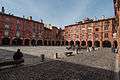 National square in Montauban
 Bruniquel, one of the formally listed "Most Beautiful Villages of France"
 Saint Barthelemy church in Lauzerte
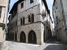 The "King's House" in Saint-Antonin-Noble-Val
 Saint Peter abbey in Moissac
References
- ↑ Harry Rothwell (Editor) English Historical Documents 1189-1327, Routledge, 1996, ISBN 0-415-14368-3
- ↑ Haine, W. Scott (2000). The History of France. Greenwood Publishing Group. p. 45. ISBN 978-0-313-30328-9.
- ↑ Fenby, Jonathan (2015). The History of Modern France: From the Revolution to the Present Day. Simon & Schuster UK. ISBN 978-1-4711-2931-5.
- 1 2 3 Pascale Marouseau. "Création du département de Tarn-et-Garonne". Archives de France (in French). Archives départementales de Tarn-et-Garonne. Retrieved 2015-09-18.
- 1 2 Philips' Modern School Atlas. George Philip and Son, Ltd. 1973. p. 43. ISBN 0-540-05278-7.
- ↑ Vois Navigables France Itinéraires Fluviaux. Editions De L'Ecluse. 2009. ISBN 978-2-916919-21-8.
- ↑ Castanet IGN
- ↑ Michelet, Jules (1847). History of France. D. Appleton. p. 150.
See also
- Cantons of the Tarn-et-Garonne department
- Communes of the Tarn-et-Garonne department
- Arrondissements of the Tarn-et-Garonne department
External links
- (French) Prefecture of Tarn-et-Garonne website
- (French) General council of Tarn-et-Garonne website
- (French) Arkheia History Review of Tarn-et-Garonne website