Taunton Green Historic District
|
Taunton Green Historic District | |
|
Taunton Green, looking east toward Main Street | |
  | |
| Location | Taunton, Massachusetts |
|---|---|
| Coordinates | 41°54′8″N 71°5′40″W / 41.90222°N 71.09444°WCoordinates: 41°54′8″N 71°5′40″W / 41.90222°N 71.09444°W |
| Area | 50 acres (20 ha) |
| Built | 1830 |
| Architect | Multiple |
| Architectural style | Late 19th and 20th Century Revivals, Late Victorian |
| MPS | Taunton MRA |
| NRHP Reference # | [1] |
| Added to NRHP | March 1, 1985 |
The Taunton Green Historic District is a historic area located at the center of the city of Taunton, Massachusetts at the junction of Broadway, Taunton Green, Main and Court Streets. It forms the intersection of U.S. Route 44 and State routes 140 and 138.
The green was laid out in 1830 and added to the National Register of Historic Places in 1985 and contains approximately 20 buildings on 50 acres (20 ha).[2] The Taunton Green Historic District directly abuts the Bristol County Courthouse Complex historic district.[3]
Taunton Green has historically the gathering place for troops headed to war and since 1914 it has hosted the city's annual holiday light display which attracts visitors from throughout the area, giving Taunton the nickname of "The Christmas City".[4]
In July 2004, the historic Templar's Hall (c. 1850) and Cohannet Block (1870) (commonly referred to as the Seeley Building) located on the corner of Taunton Green and Weir Street were destroyed by an arsonist.[5]
Contributing properties
(partial listing)
- Taunton Green (historic town common)
- J.R. Tallman & Co, Inc. (1913), 11-12 Court Street
- Crocker Building (1898), 4 Court Street
- Boys & Girls Club of Taunton (1913), 31 Court Street
- 43 Taunton Green (1831), current facade added in 1893
- Dunbar Block (c. 1830), 44-49 Taunton Green
- Union Block (1860), 1-37 Main Street
- Bank Blocks (c. 1855), 4, 5 & 9 Taunton Green
- Taylor Building (1889), 10-14 Taunton Green
- Jones Block (1874), 5-29 Broadway
- Donovan Building (c. 1900), 28 Broadway
Properties with separate NRHP Listings
- United States Post Office (1932), 37 Taunton Green
See also
- National Register of Historic Places listings in Taunton, Massachusetts
- Taunton City Hall
- Church Green
Gallery
 Taunton Green in c. 1905
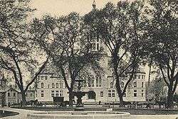 Historic view of Taunton Green with Bristol County Superior Courthouse in the distance
 Annual holiday light display on Taunton Green
 World War I memorial on Taunton Green
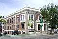 Crocker Building
 Dunbar Block
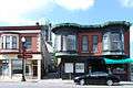 Donovan Block
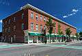 Jones Block
 Taylor Block
 Union Block
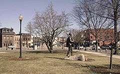
 County Courthouse and The Hiker statue
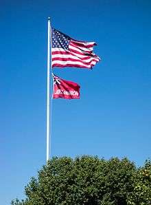 The flag of Taunton flies alongside the flag of the United States over Taunton Green
References
- ↑ National Park Service (2008-04-15). "National Register Information System". National Register of Historic Places. National Park Service.
- ↑ MASSACHUSETTS - Bristol County - Historic Districts
- ↑ Walking Tours Taunton, Massachusetts; a guide to historic properties, Taunton Historic District Commission, 1998
- ↑ Taunton Daily Gazette article, October 20, 2008
- ↑ Taunton Daily Gazette article 12/30/04
External links
| Topics |  | ||||||||||||||||||||||||||||||
|---|---|---|---|---|---|---|---|---|---|---|---|---|---|---|---|---|---|---|---|---|---|---|---|---|---|---|---|---|---|---|---|
| Lists by county | |||||||||||||||||||||||||||||||
| Lists by city |
| ||||||||||||||||||||||||||||||
| Other lists | |||||||||||||||||||||||||||||||
| |||||||||||||||||||||||||||||||