Tazewell, Tennessee
| Tazewell, Tennessee | |
|---|---|
| Town | |
|
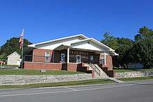
Tazewell City Hall | |
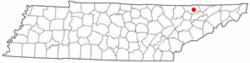 Location of Tazewell, Tennessee | |
| Coordinates: 36°27′16″N 83°34′16″W / 36.45444°N 83.57111°WCoordinates: 36°27′16″N 83°34′16″W / 36.45444°N 83.57111°W | |
| Country | United States |
| State | Tennessee |
| County | Claiborne |
| Incorporated | 1801[1] |
| Named for | Henry Tazewell |
| Area | |
| • Total | 4.4 sq mi (11.3 km2) |
| • Land | 4.4 sq mi (11.3 km2) |
| • Water | 0.0 sq mi (0.0 km2) |
| Elevation | 1,362 ft (415 m) |
| Population (2010) | |
| • Total | 2,218 |
| • Density | 496.0/sq mi (191.5/km2) |
| Time zone | Eastern (EST) (UTC-5) |
| • Summer (DST) | EDT (UTC-4) |
| ZIP code | 37879 |
| Area code(s) | 423 |
| FIPS code | 47-73120[2] |
| GNIS feature ID | 1272257[3] |
Tazewell is a town in and the county seat of Claiborne County, Tennessee, United States.[4] The population was 2,165 at the 2000 census and 2,218 at the 2010 census. The town is named for Henry Tazewell (1753–1799), a U.S. senator from Virginia.[5]
History
In 1750, Dr. Thomas Walker of Virginia publicized the location of Cumberland Gap, which brought a stream of long hunters down the Clinch and Powell valleys into what is now Claiborne County.[6] The land at the time was part of Cherokee and Shawano hunting grounds,[7] and hostile attacks by members of these two tribes were not uncommon. To protect themselves, hunters, fur traders and early settlers erected a series of small forts and stations along the Powell and Clinch valleys. One such station, known as Fort Butler, was located just west of modern Tazewell.[8]
Among the earliest settlers in the Tazewell area was John Hunt (1750–1822), a militia captain who would later be instrumental in the founding of Huntsville, Alabama. In 1804, three years after the creation of Claiborne County, Tazewell was chosen as the county seat due in part to Hunt's influence (although a local legend states that the residents of Tazewell's rival for the seat, Springdale, were too intoxicated to vote on the day of selection). Hunt was named the county's first sheriff, and the government met at his house until a courthouse was constructed.[9] The original courthouse was a wooden structure which had hitching posts for horses in front.
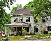
In 1862, at the height of the Civil War, Confederate troops occupied Tazewell as part of the greater struggle for the strategic Cumberland Gap. When the Confederates evacuated the town in November of that year, a fire followed, destroying much of Tazewell.[10] The town retains a number of historical structures, mostly from the Victorian era.
Notable people from Tazewell include State Representative Boyd C. Fugate (1884-1967).
Geography
Tazewell is located at 36°27′16″N 83°34′16″W / 36.45444°N 83.57111°W (36.454408, -83.571074).[11] The town is situated on the northern slope of Wallen Ridge, the northernmost of a series of long, narrow ridges that comprise the Ridge and Valley Province of the Appalachian Mountains. Big Barren Creek rises in the western section of Tazewell and flows southwestward for approximately 10 miles (16 km) before emptying into the Norris Lake impoundment of the Clinch River. The streams in the eastern section of Tazewell are part of the watershed of the Powell River, a Clinch tributary that flows westward a few miles north of Tazewell.
Tazewell is centered just east of the junction of U.S. Route 25, which connects the town to Morristown to the southeast and Middlesboro, Kentucky to the north, and State Route 33, which connects the town to Maynardville to the southwest and the upper Clinch Valley to the northeast.
According to the United States Census Bureau, the town has a total area of 4.4 square miles (11 km2), all land.
Demographics
| Historical population | |||
|---|---|---|---|
| Census | Pop. | %± | |
| 1870 | 345 | — | |
| 1880 | 342 | −0.9% | |
| 1910 | 886 | — | |
| 1920 | 424 | −52.1% | |
| 1960 | 1,264 | — | |
| 1970 | 1,860 | 47.2% | |
| 1980 | 2,090 | 12.4% | |
| 1990 | 2,150 | 2.9% | |
| 2000 | 2,165 | 0.7% | |
| 2010 | 2,218 | 2.4% | |
| Est. 2015 | 2,288 | [12] | 3.2% |
| Sources:[13][14] | |||
As of the census[2] of 2000, there were 2,165 people, 918 households, and 588 families residing in the town. The population density was 496.0 people per square mile (191.7/km²). There were 987 housing units at an average density of 226.1 per square mile (87.4/km²). The racial makeup of the town was 94.00% White, 4.02% African American, 0.42% Native American, 0.60% Asian, 0.05% Pacific Islander, 0.05% from other races, and 0.88% from two or more races. Hispanic or Latino of any race were 0.74% of the population.

There were 918 households out of which 27.2% had children under the age of 18 living with them, 44.7% were married couples living together, 16.3% had a female householder with no husband present, and 35.9% were non-families. 32.0% of all households were made up of individuals and 14.1% had someone living alone who was 65 years of age or older. The average household size was 2.20 and the average family size was 2.73.
In the town the population was spread out with 19.4% under the age of 18, 9.4% from 18 to 24, 26.2% from 25 to 44, 25.6% from 45 to 64, and 19.4% who were 65 years of age or older. The median age was 41 years. For every 100 females there were 82.4 males. For every 100 females age 18 and over, there were 79.8 males.
The median income for a household in the town was $22,288, and the median income for a family was $32,813. Males had a median income of $25,721 versus $19,479 for females. The per capita income for the town was $16,688. About 20.0% of families and 22.2% of the population were below the poverty line, including 29.9% of those under age 18 and 19.9% of those age 65 or over.
Education
- Satellite campus of Walters State Community College.
- Claiborne High School
- Soldiers Memorial School
- Tazewell-New Tazewell Primary School
- Heritage Christian Academy
References
- ↑ Tennessee Blue Book, 2005-2006, pp. 618-625.
- 1 2 "American FactFinder". United States Census Bureau. Retrieved 2008-01-31.
- ↑ "US Board on Geographic Names". United States Geological Survey. 2007-10-25. Retrieved 2008-01-31.
- ↑ "Find a County". National Association of Counties. Retrieved 2011-06-07.
- ↑ Jim Matheny, "Why Do They Call It That? Tazewell and New Tazewell." WBIR.com, 5 November 2010. Retrieved: 4 February 2011.
- ↑ John Kivett, "Claiborne County." The Tennessee Encyclopedia of History and Culture, 2002. Retrieved: 19 February 2008.
- ↑ Edgar Holt, Claiborne County (Memphis, Tenn.: Memphis State University Press, 1981), 4-6.
- ↑ "Goodspeed's History of Claiborne County," 1887. Transcribed for web content by Joe Payne, 2001. Retrieved: 19 February 2008.
- ↑ Holt, Claiborne County, 10-12.
- ↑ National Register of Historic Places Registration Form for the Claiborne County Jail, Sec. 8: 5. 20 September 2006. Retrieved: 19 February 2008.
- ↑ "US Gazetteer files: 2010, 2000, and 1990". United States Census Bureau. 2011-02-12. Retrieved 2011-04-23.
- ↑ "Annual Estimates of the Resident Population for Incorporated Places: April 1, 2010 to July 1, 2015". Retrieved July 2, 2016.
- ↑ "Census of Population and Housing: Decennial Censuses". United States Census Bureau. Retrieved 2012-03-04.
- ↑ "Incorporated Places and Minor Civil Divisions Datasets: Subcounty Resident Population Estimates: April 1, 2010 to July 1, 2012". Population Estimates. U.S. Census Bureau. Retrieved 11 December 2013.
External links
| Wikimedia Commons has media related to Tazewell, Tennessee. |
- Claiborne County Chamber of Commerce
- Joe Payne's Claiborne County Page — a large collection of historical documents and photographs pertaining the history of Tazewell and Claiborne County
Municipalities and communities of Claiborne County, Tennessee, United States | ||
|---|---|---|
| City | ||
| Towns | ||
| Unincorporated communities | ||
| Footnotes | ‡This populated place also has portions in an adjacent county or counties | |