Terrey Hills, New South Wales
| Terrey Hills Sydney, New South Wales | |||||||||||||
|---|---|---|---|---|---|---|---|---|---|---|---|---|---|
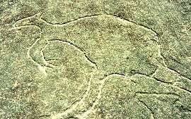 Aboriginal rock carving, Larool Road | |||||||||||||
| Coordinates | 33°40′59″S 151°13′23″E / 33.683°S 151.223°ECoordinates: 33°40′59″S 151°13′23″E / 33.683°S 151.223°E | ||||||||||||
| Population | 2,876 (2006 census)[1] | ||||||||||||
| Postcode(s) | 2084 | ||||||||||||
| Location | 25 km (16 mi) north of Sydney CBD | ||||||||||||
| LGA(s) | Warringah Council | ||||||||||||
| State electorate(s) | Pittwater | ||||||||||||
| Federal Division(s) | Mackellar | ||||||||||||
| |||||||||||||
| |||||||||||||
Terrey Hills is a suburb of northern Sydney, in the state of New South Wales, Australia 25 kilometres north of the Sydney central business district in the local government area of Warringah Council. It is part of the Northern Beaches region.[2]
Terrey Hills is also considered to be part of the Forest District, colloquially known as The Forest. Terrey Hills is a very leafy suburb and in some areas semi-rural, with many people boarding their horses in the area.
History
Terrey Hills owes its name to the two original land holders Samuel Hills and Obediah James Terrey. Obediah Terrey acquired 640 acres (2.6 km2) in 1881 and Samuel Hills owned 100 acres (0.40 km2) nearby.[3]
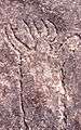
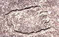
The area was used by Aborigines prior to European settlement, and rock carvings exist in some places. One set of carvings is located near Larool Road [4] and depicts hunting scenes with kangaroos, human figures and footprints.
Terrey Hills Post Office opened on 17 June 1935.[5]
For the older (geological) history, Terrey Hills is noted as the "laterite capital" of the Sydney Basin for those interested in how laterite forms (which has commonly been taken as indicator of climate change, and signalling former hotter and wetter conditions). The laterite of Terrey Hills was used for early road-making and also has been used for rock wall coastal defence at Collaroy Beach. It is the only place in New South Wales where fossils (meagre plant fibres) have been noted in laterite. The main laterite quarry (now the Terrey Hills playing field), and a smaller one at Tumbledown Dick, are on the National Estate (a Commonwealth heritage listing) and also have been nominated to the NSW Government local-significance heritage listing which in this area is administered by the Northern Rivers Council. A small struggle has been ongoing for years to better protect the laterite exposure at Tumbledown Dick from the announced effects of Mona Vale road widening plans. The laterite was worked during the Great Depression when Australia had one third of the workforce out of work. The Warringah Shire Quarry or 'gravel pit' at Terrey Hills was an important place for the distribution of government relief work funding. Gai Halstead in 1988 wrote a bicentennial compilation which was sponsored by Dick Smith's "Australian Geographical" organisation which was then headquartered at Terrey Hills - "The story of Terry Hills and Duffys Forest". In this it is noted that married men were given work at the rate of two weeks on and one off, whereas the single men worked at the 'gravel pit' at the rate of one week on and two off. Apart from this work there was little other work available at the time and Ms Halstead recorded the people at Terrey Hills were generally impoverished. For a week's work digging laterite gravel with pick and shovel there was received £1. To be paid that, they had to walk to the 'relief office' at Narrabeen. Besides digging the laterite, the relief workers based at Terrey Hills also built or improved the roads from Terrey Hills to Mona Vale, Cottage Point and Coal and Candle Creek. The area is generally poor in fossils and the only further thing of note is that a member of the local volunteer bush fire brigade found a fossil footprint in stone fallen from the bank of McCarr's Creek near the Duck Hole. This might be comparable to a labyrinthodont track found in Hawkesbury Sandstone at Berowra Heights.
-

This image and following: Aboriginal rock carvings, Larool Road
-
-
Climate
Owing to its elevation and proximity to the ocean, the weather station at Terrey Hills records the mildest temperatures of any weather station in the Greater Sydney region.
| Climate data for Terrey Hills | |||||||||||||
|---|---|---|---|---|---|---|---|---|---|---|---|---|---|
| Month | Jan | Feb | Mar | Apr | May | Jun | Jul | Aug | Sep | Oct | Nov | Dec | Year |
| Record high °C (°F) | 43.9 (111) |
40.3 (104.5) |
35.6 (96.1) |
32.2 (90) |
27.2 (81) |
21.9 (71.4) |
23.6 (74.5) |
27.9 (82.2) |
32.7 (90.9) |
36.3 (97.3) |
39.5 (103.1) |
40.3 (104.5) |
43.9 (111) |
| Average high °C (°F) | 26.5 (79.7) |
25.8 (78.4) |
24.8 (76.6) |
22.1 (71.8) |
19.5 (67.1) |
16.4 (61.5) |
16.0 (60.8) |
17.9 (64.2) |
20.8 (69.4) |
22.8 (73) |
24.0 (75.2) |
25.2 (77.4) |
21.8 (71.2) |
| Average low °C (°F) | 18.2 (64.8) |
18.1 (64.6) |
16.8 (62.2) |
13.8 (56.8) |
10.7 (51.3) |
8.8 (47.8) |
7.5 (45.5) |
8.4 (47.1) |
11.2 (52.2) |
13.2 (55.8) |
15.4 (59.7) |
16.4 (61.5) |
13.2 (55.8) |
| Record low °C (°F) | 11.9 (53.4) |
11.6 (52.9) |
10.4 (50.7) |
5.5 (41.9) |
4.3 (39.7) |
0.9 (33.6) |
0.2 (32.4) |
1.5 (34.7) |
4.2 (39.6) |
6.0 (42.8) |
5.8 (42.4) |
9.3 (48.7) |
0.2 (32.4) |
| Source: [6] (averages and records) | |||||||||||||
Commercial area
The shopping centre includes an IGA supermarket, a Post Office, specialty shops and a number of restaurants and landscaping and plant suppliers.
Warringah Council has its Volunteer Services Centre located in Thompson Drive. Terrey Hills is home to the Rural Fire Service (RFS), State Emergency Service (SES), Marine Rescue NSW, Citizens Radio Emergency Services Team (CREST) & the Wireless Institute Civil Emergency Network (WICEN) under the auspices of the Radio Society (MWRS).
In addition Terrey Hills has its own Rural Fire Station located in the car park adjacent to the Frank Beckman Reserve on Yulong Road. The volunteer brigade is the primary fire-fighting agency for the village and is equipped to fight both bush fires and structural / car fires with two fire engines and a Toyota Hilux support vehicle.
Terrey Hills is also home to the Manly-Warringah Media Co-Operative and the Radio Northern Beaches radio stations after its relocation from Belrose in 2013.
Transport
Terrey Hills is also home to the Forest Coach Lines depot, which provides regular bus services to the city and to close suburbs such as Belrose, Davidson and Frenchs Forest as well as the surrounding area. There is also a regular bus to Macquarie University and Macquarie shopping centre. Buses also run to Chatswood and Gordon railway stations, enabling passengers to access train services.
Mona Vale Road is the main road through Terrey Hills, connecting it to the rest of the Northern Beaches to the east, and suburbs such as Chatswood, Hornsby and North Ryde to the west.
Education
Terrey Hills is home to six schools:
- Northern Beaches Christian School
- The Sydney Japanese School[7]
- Terrey Hills Public School
- Kinma School
- German International School Sydney[8]
- Forestville Montessori School Secondary Campus[9]
Sport and recreation
There are also sporting facilities including two golf courses, two tennis centres with numerous courts available, and several BMX tracks where competitions and races are held. Rotary International has a branch in Terrey Hills branch, that meets regularly at one of the local restaurants.
The Manly-Warringah Radio Society (VK2MB), the local northern beaches Amateur Radio club, has its meetings at the Terrey Hills Girl Guides hall every Wednesday evening.
The Terrey Hills Wolves are the local Rugby Union Club. They play in the Sydney Suburban Rugby sixth division Meldrum Cup competition. Their clubhouse is on the club's home ground, Yulong Oval. The local soccer team is The Belrose Terrey Hills Raiders.
References
- ↑ Australian Bureau of Statistics (25 October 2007). "Terrey Hills (State Suburb)". 2006 Census QuickStats. Retrieved 28 February 2008.
- ↑ Gregory's Sydney Street Directory, Gregory's Publishing Company, 2007
- ↑ Book of Sydney Suburbs, Francis Pollon, Angus and Robertson, 1990, page 254
- ↑ Gregory's Sydney Street Directory, Gregory's Publishing Company, 1983-1984
- ↑ Premier Postal History. "Post Office List". Premier Postal Auctions. Retrieved 12 June 2012.
- ↑ "Climate Statistics: Terrey Hills". Bureau of Meteorology. Retrieved 21 July 2016.
- ↑ "School Location." Sydney Japanese International School. Retrieved on 4 January 2014. "112 Booralie Road, Terrey Hills, NSW 2084 Australia"
- ↑ "Contact Us." German International School Sydney. Retrieved on 7 April 2015. "33 Myoora Road Terrey Hills NSW 2084"
- ↑ http://www.forestcoachlines.com.au/html/school/schools/45.html