Texas State Highway 309
| ||||
|---|---|---|---|---|
 | ||||
| Route information | ||||
| Maintained by TxDOT | ||||
| Length: | 11.684 mi[1] (18.804 km) | |||
| Existed: | by 1939 – present | |||
| Major junctions | ||||
| South end: |
0.5 miles (0.8 km) south of | |||
|
| ||||
| North end: |
| |||
| Highway system | ||||
| ||||

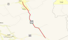
State Highway 309 or SH 309 is a Texas state highway that runs from Kerens south to U.S. Highway 287 near the Richland-Chambers Reservoir. This route was designated by 1939 along its current path, which extended another mile to the south. This section, from the new route of US 287 south to the old location of US 287, was removed in 1990, as portions of the route and US 287 were submerged by the newly impounded Richland Chambers Reservoir.
Route description
SH 309 begins 0.5 miles (0.8 km) south of US 287 and heads north to a junction with US 287. It heads northwest from this junction to an intersection with FM 635. The highway continues to the northwest to an intersection with FM 1393. Heading towards the northwest, the highway continues to an intersection with FM 3096 in Kerens. SH 309 reaches its northern terminus at SH 31 in Kerens.[2]
Junction list
The entire route is in Navarro County.
| Location | mi | km | Destinations | Notes | |
|---|---|---|---|---|---|
| | |||||
| | |||||
| | |||||
| Kerens | |||||
| 1.000 mi = 1.609 km; 1.000 km = 0.621 mi | |||||
References
- ↑ Transportation Planning and Programming Division (n.d.). "State Highway No. 309". Highway Designation Files. Texas Department of Transportation. Retrieved 2008-03-14.
- ↑ Google (2008-03-14). "overview map of SH 309" (Map). Google Maps. Google. Retrieved 2008-03-14.