Texas State Highway 57
| ||||
|---|---|---|---|---|
 | ||||
| Route information | ||||
| Maintained by TxDOT | ||||
| Length: | 1.474 mi[1] (2.372 km) | |||
| Existed: | 1994 – present | |||
| Major junctions | ||||
| West end: |
| |||
| East end: |
| |||
| Location | ||||
| Counties: | Smith | |||
| Highway system | ||||
| ||||

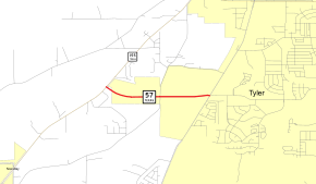
State Highway 57 (SH 57) is a 1.474-mile (2.372 km) Texas state highway located in Tyler.[1]
Route description
SH 57 begins at an intersection with SH 155 in southwestern Tyler. The route travels to the east before ending at FM 2493. The roadway continues under local maintenance as Grande Boulevard.[1][2] SH 57 is four lanes with a center turn lane for its entire length.[3]
History
SH 57 was originally designated by 1926 on a route along the Gulf Coast from Tivoli to near Corpus Christi. By 1928, it had extended to Palacios. By 1935, this route was renumbered as part of SH 35.[4]
The SH 57 designation was once again used beginning in 1966, on a route from Eagle Pass to near Moore, as a renumbering of SH 76 and to coincide with Mexican Federal Highway 57. This route would be renumbered US 57 in 1971.[1]
The current SH 57 was designated in 1994.[1] There are plans for the highway to be extended west to connect with Segment 3 of the under construction Loop 49.
Major intersections
The entire route is in Tyler, Smith County.
| mi[1] | km | Destinations | Notes | ||
|---|---|---|---|---|---|
| 0.000 | 0.000 | Western terminus | |||
| 1.474 | 2.372 | Eastern terminus; roadway continues as West Grande Boulevard | |||
| 1.000 mi = 1.609 km; 1.000 km = 0.621 mi | |||||
References
- 1 2 3 4 5 6 Transportation Planning and Programming Division (n.d.). "State Highway No. 57". Highway Designation Files. Texas Department of Transportation. Retrieved September 29, 2011.
- ↑ Transportation Planning and Programming Division (2014). Texas County Map Book (PDF) (Map) (2014 ed.). 1:120,000. Texas Department of Transportation. p. 488. Retrieved December 6, 2014.
- ↑ Google (September 29, 2011). "Overview map of Texas State Highway 57 Distances Between Interchanges" (Map). Google Maps. Google. Retrieved September 29, 2011.
- ↑ Official Map of the Highway System of Texas (Map). 1"=29 mi. Cartography by R. M. Stene. Texas State Highway Commission. Retrieved June 9, 2015.