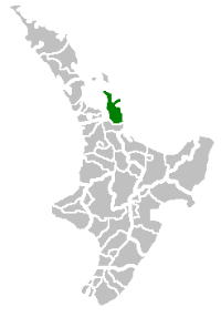
Thames-Coromandel District
| Thames-Coromandel | |
 | |
| Population: | 28,400 (territorial) (June 2016)[1] |
| Main towns: | Thames and Whitianga. |
| Other towns: | Coromandel, Whangamata, Matarangi, Whangapoua, Pauanui, Tairua and Whitianga. |
| Territorial Authority | |
|---|---|
| Name: | Thames-Coromandel District Council |
| Mayor: | Glenn Leach |
| Extent: | Colville Channel to Whangamata;
Hauraki Gulf to Bay of Plenty |
| Land Area: | 2,297 km² |
| Website: | http://www.tcdc.govt.nz |
| See also: | Hauraki District, Tauranga |
| Regional Council | |
| Name: | Environment Waikato |
| Website: | http://www.ew.govt.nz/ |
The Thames-Coromandel District Council in the North Island of New Zealand is seated in the town of Thames. It is located in the region around the Firth of Thames and Coromandel Peninsula, to the southeast of Auckland. It is the first District council to be formed in New Zealand, being constituted in 1975.
Population
The district had a population of 28,400 at the June 2016.[1] From the 2006 census 6,756 live in Thames, 3,768 in Whitianga, 3,555 in Whangamata, and 1,476 in Coromandel.
Local government
The Thames-Coromandel District Council was formed from the amalgamation of the former Thames Borough and Coromandel County Council in 1975, and is governed by the Mayor of Thames-Coromandel.[2]
References
- 1 2 "Subnational Population Estimates: At 30 June 2016 (provisional)". Statistics New Zealand. 21 October 2016. Retrieved 21 October 2016. For urban areas, "Subnational population estimates (UA, AU), by age and sex, at 30 June 1996, 2001, 2006-16 (2017 boundary)". Statistics New Zealand. 21 October 2016. Retrieved 21 October 2016.
- ↑ "Council History". Thames-Coromandel District Council. Retrieved 18 May 2012.
External links
Coordinates: 36°56′31″S 175°40′34″E / 36.942°S 175.676°E