Seine
| Seine (La Seine) | |
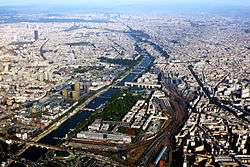 The Seine in Paris | |
| Country | France |
|---|---|
| Tributaries | |
| - left | Yonne, Loing, Eure, Risle |
| - right | Ource, Aube, Marne, Oise, Epte |
| Mouth | |
| - elevation | 0 m (0 ft) |
 Topographic map of the Seine basin
| |
The Seine (/seɪn/ SAYN; French: La Seine, pronounced: [la sɛːn]) is a 777-kilometre (483 mi) long river and an important commercial waterway within the Paris Basin in the north of France. It rises at Source-Seine, 30 kilometres (19 mi) northwest of Dijon in northeastern France in the Langres plateau, flowing through Paris and into the English Channel at Le Havre (and Honfleur on the left bank).[1] It is navigable by ocean-going vessels as far as Rouen, 120 kilometres (75 mi) from the sea. Over 60 percent of its length, as far as Burgundy, is negotiable by commercial riverboats and nearly its whole length is available for recreational boating; excursion boats offer sightseeing tours of the Rive Droite and Rive Gauche within the city of Paris.
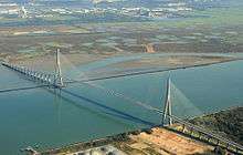
There are 37 bridges within Paris and dozens more spanning the river outside the city. Examples in Paris include the Pont Alexandre III and Pont Neuf, the latter of which dates back to 1607. Outside the city, examples include the Pont de Normandie, one of the longest cable-stayed bridges in the world, which links Le Havre to Honfleur.
The source

The Seine rises in the commune of Source-Seine, about 30 kilometres (19 mi) northwest of Dijon. The source has been owned by the city of Paris since 1864. A number of closely associated small ditches or depressions provide the source waters, with an artificial grotto laid out to highlight and contain a deemed main source. The grotto includes a statue of a nymph. On the same site are the buried remains of a Gallo-Roman temple. Small statues of the dea Sequana "Seine goddess" and other ex voti found at the same place are now exhibited in the Dijon archeological museum.
The course of the river
The Seine can artificially be divided into five parts :
- the Petite Seine "Small Seine" from the sources to Montereau-Fault-Yonne
- the Haute Seine "Upper Seine" from Montereau-Fault-Yonne to Paris
- the Traversée de Paris "the Paris waterway"
- the Basse Seine "Lower Seine" from Paris to Rouen
- the Seine maritime "Maritime Seine" from Rouen to the English channel.
Navigation
The Seine is dredged and oceangoing vessels can dock at Rouen, 120 kilometres (75 mi) from the sea. Commercial riverboats can use the river from Bar-sur-Seine, 560 kilometres (350 mi) to its mouth. At Paris, there are 37 bridges. The river is only 24 metres (79 ft) above sea level 446 kilometres (277 mi) from its mouth, making it slow flowing and thus easily navigable.
The Seine Maritime, 105.7 kilometres (65.7 mi) from the English Channel at Le Havre to Rouen, is the only portion of the Seine used by ocean-going craft.[2] The tidal section of the Seine Maritime is followed by a canalized section with four large multiple locks until the mouth of the Oise at Conflans-Sainte-Honorine. Multiple locks at Bougival / Chatou and at Suresnes lift the vessels to the level of the river in Paris, where the mouth of the Marne is located. Upstream from Paris seven locks ensure navigation to Saint Mammès, where the Loing mouth is situated. Through an eighth lock the river Yonne is reached at Montereau-Fault-Yonne. From the mouth of the Yonne, larger ships can continue upstream to Nogent-sur-Seine. From there on, the river is navigable only by small craft. All navigation ends abruptly at Marcilly-sur-Seine, where the ancient Canal de la Haute-Seine used to allow vessels to continue all the way to Troyes. This canal has been abandoned for many years.[3]
The average depth of the Seine today at Paris is about 9.5 metres (31 ft). Until locks were installed to raise the level in the 1800s, the river was much shallower within the city most of the time, and consisted of a small channel of continuous flow bordered by sandy banks (depicted in many illustrations of the period). Today the depth is tightly controlled and the entire width of the river between the built-up banks on either side is normally filled with water. The average flow of the river is very low, only a few cubic metres per second, but much higher flows are possible during periods of heavy runoff. Special reservoirs upstream help to maintain a constant level for the river through the city, but during periods of extreme runoff significant increases in river level may occur.
Flooding
A very severe period of high water in January 1910 produced extensive flooding throughout the city. The Seine again rose to threatening levels in 1924, 1955, 1982, 1999–2000 and June 2016.[4] After a first-level flood alert in 2003, about 100,000 works of art were moved out of Paris, the largest relocation of art since World War II. Much of the art in Paris is kept in underground storage rooms that would have been flooded.[5] A 2002 report by the French government stated the worst-case Seine flood scenario would cost 10 billion euros and cut telephone service for a million Parisians, leaving 200,000 without electricity and 100,000 without gas.[6]
Watershed
The basin area is 78,910 square kilometres (30,470 sq mi),[7] 2 percent of which is forest and 78 percent cultivated land. In addition to Paris, three other cities with a population over 100,000 are in the Seine watershed: Le Havre at the estuary, Rouen in the Seine valley and Reims at the northern limit—with an annual urban growth rate of 0.2 percent.[7] The population density is 201 per square kilometer.
Water quality
Periodically the sewerage systems of Paris experience a failure known as sanitary sewer overflow, often in periods of high rainfall. Under these conditions untreated sewage has been discharged into the Seine.[8] The resulting oxygen deficit is principally caused by allochthonous bacteria larger than one micrometre in size. The specific activity of these sewage bacteria is typically three to four times greater than that of the autochthonous (background) bacterial population. Heavy metal concentrations in the Seine are relatively high.[9] The pH level of the Seine at Pont Neuf has been measured to be 8.46. Despite this, the water quality has improved significantly over what several historians at various times in the past called an "open sewer".[10]
In 2009, it was announced that Atlantic salmon had returned to the Seine.[11]
History


Name
The name "Seine" comes from the Latin Sequana, the Gallo-Roman goddess of the river.[12]
Events
In March, 1314, King Philip IV of France had Jacques de Molay, last Grand Master of the Knights Templar, burned on a scaffold on an island in the River Seine in front of Notre Dame de Paris [13]
After the burning at the stake of Joan of Arc in 1431, her ashes were thrown into the Seine from the medieval stone Mathilde Bridge at Rouen, though unserious counter-claims persist.[14]
According to his will, Napoleon, who died in 1821, wished to be buried on the banks of the Seine. His request was not granted.
At the 1900 Summer Olympics, the river hosted the rowing, swimming, and water polo events.[15] Twenty-four years later, it hosted the rowing events again at Bassin d'Argenteuil, along the Seine north of Paris.[16]
Until the 1930s, a towing system using a chain on the bed of the river existed to facilitate movement of barges upriver.World Canals by Charles Hadfield, David and Charles 1986
The Seine was one of the original objectives of Operation Overlord in 1944. The Allies' intention was to reach the Seine by 90 days after D-Day. That objective was met. An anticipated assault crossing of the river never materialized as German resistance in France crumbled by early September 1944. However, the First Canadian Army did encounter resistance immediately west of the Seine and fighting occurred in the Forêt de la Londe as Allied troops attempted to cut off the escape across the river of parts of the German 7th Army in the closing phases of the Battle of Normandy.
Some of the Algerian victims of the Paris massacre of 1961 drowned in the Seine after being thrown by French policemen from the Pont Saint-Michel and other locations in Paris.
Dredging in the 1960s mostly eliminated tidal bores on the lower river, known in French as "le mascaret."
In 1991 UNESCO added the banks of the Seine in Paris—the Rive Gauche and Rive Droite—to its list of World Heritage Sites in Europe.[17]
Since 2002 Paris-Plages has been held every summer on the Paris banks of the Seine: a transformation of the paved banks into a beach with sand and facilities for sunbathing and entertainment.
The river is a popular site for both suicides and the disposal of bodies of murder victims.[18] In 2007, 55 bodies were retrieved from its waters; in February 2008, the body of supermodel-turned-activist Katoucha Niane was found there.[18]
In fiction
The Seine was the river that Javert, the primary antagonist of Victor Hugo's 1862 novel Les Misérables drowned himself in.
In art
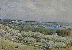
During the 19th and the 20th centuries in particular the Seine inspired many artists, including:
- Frédéric Bazille
- Maurice Boitel
- Richard Parkes Bonington
- Eugène Boudin
- Camille Corot
- Charles-François Daubigny
- Raoul Dufy
- Othon Friesz
- Carl Fredrik Hill
- Eugène Isabey
- Johan Barthold Jongkind
- Raimond Lecourt
- Albert Marquet
- Henri Matisse
- Claude Monet
- Luis F. Pinzón
- Camille Pissarro
- Emilio Grau Sala
- Gaston Sébire
- Georges-Pierre Seurat
- Alfred Sisley
- Constant Troyon
- J. M. W. Turner
- Félix Vallotton
- Édouard Vuillard
A song 'La Seine' by Flavien Monod and Guy Lafarge was written in 1948.
Josephine Baker recorded a song 'La Seine' [19]
A song 'La seine' by Vanessa Paradis feat. Matthieu Chedid was originally written as a soundtrack for the movie 'A Monster in Paris'
See also
- The department of Seine, abolished in 1968
- Seine River Steamers
-

Georges Seurat's Sunday Afternoon on the Island of La Grande Jatte (1884–1886) is set on an island in the Seine.
-
Carl Fredrik Hill, Seine-Landschaft bei Bois-Le-Roi (Seine Landscape in Bois-Le-Roi) (1877).
-
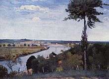
Alfred Sisley, The Terrace at Saint-Germain, Spring (1875) in the Walters Art Museum gives a panoramic view of the Seine river valley.
Notes and references
- ↑ A hand book up the Seine. G.F. Cruchley, 81, Fleet Street, 1840. Retrieved 10 June 2010.
- ↑ Vois Navigables France Itinéraires Fluviaux. Editions De L'Ecluse. 2009. ISBN 978-2-916919-21-8.
- ↑ "NoorderSoft Waterways Database".
- ↑ Seine river Basin, United Nations Environment Programme Department of Early Warning and Assessment (accessed 5 June 2007
- ↑ "Fearing a Big Flood, Paris Moves Art" by Alan Riding, The New York Times, 19 February 2003
- ↑ "Paris flood warning" by Rory Mulholland, BBC News, 25 January 2002
- 1 2 "World Resources Institute". Earthtrends.wri.org. 22 February 1999. Retrieved 18 May 2011.
- ↑ Martin Seidl, The fate of organic matter in river Seine after a combined sewer overflow, ENPC – University Paris Val de Marne Paris XII (France), 1997, 181 pp.
- ↑ J.F.Chiffoleau. 2007. Metal contamination. the Seine-Aval scientific programme. Quae. 40 pages
- ↑ Hogan, C. Michael (2006). Water quality of fresh water bodies in France. Aberdeen: Lumina Press.
- ↑ "Radio France Internationale – Atlantic salmon return to river Seine". Rfi.fr. Retrieved 18 May 2011.
- ↑ Wiktionary:Sequana
- ↑ A History of the Inquisition of the Middle Ages Vol. III by Henry Charles Lea, NY: Hamper & Bros, Franklin Sq. 1888, p. 325. Not in copyright.
- ↑ In February 2006 a team of forensic scientists announced the beginning of a six-month study to assess relics from a museum at Chinon reputed to be the remains of Jeanne d'Arc. In 2007, the investigators reported their conclusion that the relics from Chinon came from an Egyptian mummy and a cat, see Butler, Declan (2007). "Joan of Arc's relics exposed as forgery". Nature. 446 (7136): 593. doi:10.1038/446593a.
- ↑ 1900 Summer Olympics official report. pp. 17–18. (French)
- ↑ 1924 Olympics official report. pp. 165–6.
- ↑ Paris, Banks of the Seine, the World Heritage Site entry from the UNESCO website
- 1 2 Supermodel Katoucha Niane found dead from The Daily Telegraph
- ↑ https://www.youtube.com/watch?v=Mjlf18fq2do
External links
| Wikimedia Commons has media related to Seine. |
- Website on the Great Flood of 1910
- A Seine guide Places, ports and moorings on the river from le Havre and Honfleur to Paris.


