Thomasville, Pennsylvania
| Thomasville, Pennsylvania | |
|---|---|
 | |
| Coordinates: 39°53′43″N 76°51′1″W / 39.89528°N 76.85028°WCoordinates: 39°53′43″N 76°51′1″W / 39.89528°N 76.85028°W | |
| Country |
|
| State |
|
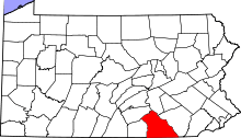
| County | York |
| Area | |
| • Total | 15.9446 sq mi (41.296 km2) |
| Population (2000) | |
| • Total | 3,647 |
| Time zone | Eastern (EST) (UTC-5) |
| • Summer (DST) | EDT (UTC-4) |
| Zip code | 17364 |
Thomasville is an unincorporated community in York County, Pennsylvania, United States, west of the city of York. Its schools are part of the Spring Grove Area School District, and the town is home to Martin's Potato Chips. Thomasville is located in Jackson Township on the Lincoln Highway, U.S. Route 30 The zip code is 17364. Thomasville is home to Thomasville Airport which houses STAT MedEvac #13.[1]
References
- ↑ Thomasville page at topix.com http://www.topix.com/city/thomasville-pa
This article is issued from Wikipedia - version of the 9/5/2016. The text is available under the Creative Commons Attribution/Share Alike but additional terms may apply for the media files.