Dallastown, Pennsylvania
| Dallastown, Pennsylvania | ||
|---|---|---|
| Borough | ||
| ||
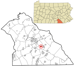 Location in York County and the state of Pennsylvania. | ||
| Coordinates: 39°54′0″N 76°38′27″W / 39.90000°N 76.64083°WCoordinates: 39°54′0″N 76°38′27″W / 39.90000°N 76.64083°W | ||
| Country | United States | |
| State | Pennsylvania | |
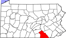
| County | York | |
| Settled | 1844 | |
| Incorporated | 1866 | |
| Government | ||
| • Type | Borough Council | |
| • Mayor | Terry Myers Sr. | |
| Area | ||
| • Total | 0.7 sq mi (2 km2) | |
| Elevation | 876 ft (267 m) | |
| Population (2010) | ||
| • Total | 4,049 | |
| • Density | 5,800/sq mi (2,200/km2) | |
| Time zone | Eastern (EST) (UTC-5) | |
| • Summer (DST) | EDT (UTC-4) | |
| Zip code | 17313 | |
| Area code(s) | 717 | |
| Website | Dallastown | |

Dallastown is a borough in York County, Pennsylvania, United States. The population was 4,049 at the 2010 census.[1]
History
Dallastown was named after George M. Dallas of Philadelphia (Vice President of the United States during the Polk administration) during the presidential campaign of 1844. Dallastown was incorporated April 1866.
President Lyndon Johnson visited Dallastown in 1966 as part of the town's centennial celebration.
Geography
According to the United States Census Bureau, the borough has a total area of 0.8 square miles (2.1 km2), all of it land.
Demographics
| Historical population | |||
|---|---|---|---|
| Census | Pop. | %± | |
| 1870 | 287 | — | |
| 1880 | 482 | 67.9% | |
| 1890 | 779 | 61.6% | |
| 1900 | 1,181 | 51.6% | |
| 1910 | 1,884 | 59.5% | |
| 1920 | 2,124 | 12.7% | |
| 1930 | 2,849 | 34.1% | |
| 1940 | 2,917 | 2.4% | |
| 1950 | 3,304 | 13.3% | |
| 1960 | 3,615 | 9.4% | |
| 1970 | 3,560 | −1.5% | |
| 1980 | 3,949 | 10.9% | |
| 1990 | 3,974 | 0.6% | |
| 2000 | 4,087 | 2.8% | |
| 2010 | 4,049 | −0.9% | |
| Est. 2015 | 4,017 | [2] | −0.8% |
| Sources:[3][4][5] | |||
As of the census[4] of 2000, there were 4,087 people, 1,622 households, and 1,026 families residing in the borough. The population density was 5,567.2 people per square mile (2,161.6/km²). There were 1,707 housing units at an average density of 2,325.2 per square mile (902.8/km²). The racial makeup of the borough was 97.19% White, 0.78% African American, 0.20% Native American, 0.34% Asian, 0.12% Pacific Islander, 0.39% from other races, and 0.98% from two or more races. Hispanic or Latino of any race were 1.79% of the population.
There were 1,622 households out of which 31.6% had children under the age of 18 living with them, 46.4% were married couples living together, 12.5% had a female householder with no husband present, and 36.7% were non-families. 29.8% of all households were made up of individuals and 12.4% had someone living alone who was 65 years of age or older. The average household size was 2.36 and the average family size was 2.91.
In the borough the population was spread out with 23.3% under the age of 18, 9.7% from 18 to 24, 31.1% from 25 to 44, 17.6% from 45 to 64, and 18.3% who were 65 years of age or older. The median age was 36 years. For every 100 females there were 90.2 males. For every 100 females age 18 and over, there were 82.6 males.
The median income for a household in the borough was $37,500, and the median income for a family was $44,500. Males had a median income of $35,679 versus $25,169 for females. The per capita income for the borough was $18,249. About 3.4% of families and 8.7% of the population were below the poverty line, including 6.7% of those under age 18 and 19.2% of those age 65 or over.
Education
Dallastown Borough is home to Dallastown Elementary School, Senior High school, and Middle School, which is part of the Dallastown Area School District, which consists of eight local schools, including the Dallastown Intermediate School, built in 2010.
St. Joseph's Catholic School is also in Dallastown. It provides Catholic education to students in grades Pre-K to 6.
Dallastown Area Senior High School has the longest hallway in a school in Pennsylvania, almost 1/3 of a mile (1,760 ft or 536.45 meters).
Notable people
- Cameron Mitchell, film and television actor, was born in Dallastown.
References
| Wikimedia Commons has media related to Dallastown, Pennsylvania. |
- ↑ "Race, Hispanic or Latino, Age, and Housing Occupancy: 2010 Census Redistricting Data (Public Law 94-171) Summary File (QT-PL), Dallastown borough, Pennsylvania". U.S. Census Bureau, American FactFinder 2. Archived from the original on September 11, 2013. Retrieved October 4, 2011.
- ↑ "Annual Estimates of the Resident Population for Incorporated Places: April 1, 2010 to July 1, 2015". Retrieved July 2, 2016.
- ↑ "Census of Population and Housing". U.S. Census Bureau. Archived from the original on May 11, 2015. Retrieved 11 December 2013.
- 1 2 "American FactFinder". United States Census Bureau. Archived from the original on September 11, 2013. Retrieved 2008-01-31.
- ↑ "Incorporated Places and Minor Civil Divisions Datasets: Subcounty Resident Population Estimates: April 1, 2010 to July 1, 2012". Population Estimates. U.S. Census Bureau. Archived from the original on June 17, 2013. Retrieved 11 December 2013.