Ticul Municipality
| Ticul | |
|---|---|
| Municipality | |
|
Ticul City Hall | |
 Region 7 Sur #089 | |
|
Ticul Location of the Municipality in Mexico | |
| Coordinates: 20°24′N 89°32′W / 20.400°N 89.533°WCoordinates: 20°24′N 89°32′W / 20.400°N 89.533°W | |
| Country |
|
| State |
|
| Government | |
| • Type |
PRI |
| • Municipal President | Orlando Rafael Medina Un[2] |
| Area | |
| • Total | 355.12 km2 (137.11 sq mi) |
| [2] | |
| Population (2010[3]) | |
| • Total | 37,685 |
| Time zone | Central Standard Time (UTC-6) |
| • Summer (DST) | Central Daylight Time (UTC-5) |
| Postal Code | 97860 |
| Area code(s) | 997 |
| INEGI Code | 089 |
| Major Airport | Merida (Manuel Crescencio Rejón) International Airport |
| IATA Code | MID |
| ICAO Code | MMMD |
| Website | Official Website |
Ticul Municipality is one of 106 municipalities in Yucatán State, Mexico. It is located in the western part of the state at (20°24′N 89°32′W / 20.400°N 89.533°W) 100 km south of the state capital city of Mérida. The municipality, which has an area of 355.12 km² (137.11 sq mi), in the 2005 census reported 25,621 inhabitants. The city of Ticul which is the municipal seat had a population of 21,147, the ninth-largest community in the state in population. The majority are ethnically Maya. Its largest other towns are Pustunich and Yotholín.
The city of Ticul was also a town of the Pre-Columbian Maya civilization. Ticul was established as a Spanish colonial town by 1549. The Republic of Yucatán granted Ticul the status of a city in 1847.
The city is nicknamed La Perla del Sur ("The Pearl of the South"), as it is in the southern part of Yucatán state.
Ticul has long been known for the red pottery produced there. In modern times, it is known for its production of shoes as well. Over half the population still speaks the Maya language as their first tongue, although Spanish is also understood. The pork dish poc-chuc is a well known local specialty.
Climate
| Climate data for Ticul | |||||||||||||
|---|---|---|---|---|---|---|---|---|---|---|---|---|---|
| Month | Jan | Feb | Mar | Apr | May | Jun | Jul | Aug | Sep | Oct | Nov | Dec | Year |
| Average high °C (°F) | 29.8 (85.6) |
31.7 (89.1) |
34.1 (93.4) |
36.7 (98.1) |
37.7 (99.9) |
35.7 (96.3) |
35.3 (95.5) |
35.1 (95.2) |
34.3 (93.7) |
32.6 (90.7) |
31 (88) |
29.9 (85.8) |
33.7 (92.7) |
| Average low °C (°F) | 15 (59) |
15.9 (60.6) |
17.6 (63.7) |
19.4 (66.9) |
21.3 (70.3) |
21.9 (71.4) |
21.2 (70.2) |
21.6 (70.9) |
21.7 (71.1) |
20.6 (69.1) |
18 (64.4) |
16.3 (61.3) |
19.2 (66.6) |
| Average precipitation mm (inches) | 20 (0.8) |
130 (5) |
36 (1.4) |
50 (2) |
114 (4.5) |
168 (6.6) |
145 (5.7) |
165 (6.5) |
191 (7.5) |
122 (4.8) |
50 (2) |
41 (1.6) |
1,229 (48.4) |
| Source: Weatherbase [4] | |||||||||||||
Communities
The municipality is made up of 32 communities the most important are as follows:
- Ticul (Municipal Seat)
- Pustunich
- Yotholin
- Plan Chac Número Cinco
- Unidades de Riego
Important people
Francisco Ché Cacique de Ticul who ruled from 1562-1569.
Picture gallery
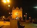
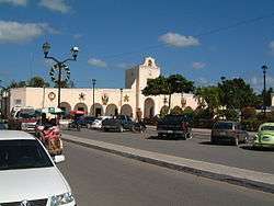
The church at night  City Hall
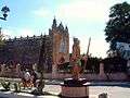 Church
References
- ↑ "Presidente Municipal" (in Spanish). Mérida, Mexico: PRI. 2012. Retrieved 6 August 2015.
- 1 2 "Municipios de Yucatán »Santa Elena" (in Spanish). Retrieved 6 August 2015.
- ↑ "Mexico In Figures:Sacalum, Yucatán". INEGI (in Spanish and English). Aguascalientes, México: Instituto Nacional de Estadística y Geografía (INEGI). Retrieved 3 August 2015.
- ↑ "Weatherbase: Historical Weather for Ticul, Yucatán". Weatherbase. 2011. Retrieved on November 24, 2011.
Mérida (capital) | |||||||||||||||||||||||||||
| Topics |  | ||||||||||||||||||||||||||
| Metros | |||||||||||||||||||||||||||
| Larger cities | |||||||||||||||||||||||||||
| Smaller cities |
| ||||||||||||||||||||||||||
| Municipalities |
| ||||||||||||||||||||||||||