Timrat
| Timrat | |
|---|---|
 | |
 Timrat | |
| Coordinates: 32°42′12.24″N 35°13′29.63″E / 32.7034000°N 35.2248972°ECoordinates: 32°42′12.24″N 35°13′29.63″E / 32.7034000°N 35.2248972°E | |
| District | Northern |
| Council | Jezreel Valley |
| Affiliation | HaMerkaz HaHakla'i |
| Founded | 1981 |
| Population (2015)[1] | 1,332 |
| Website | www.timrat.org.il |

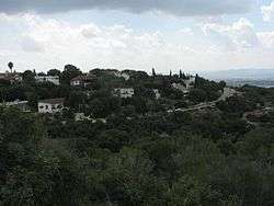
Moshav Timrat entrance
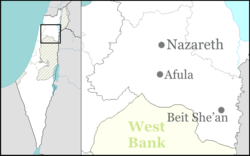
Timrat (Hebrew: תִּמְרַת, lit. Date) is a communal settlement in northern Israel. Located in the Lower Galilee near Nahalal, it falls under the jurisdiction of Jezreel Valley Regional Council. In 2015 it had a population of 1,332.
History
The village was established in 1981, though the site had previously been the location of kibbutz Timorim, which was established in 1948, but moved to the centre of the country in 1954 due to a shortage of land.[2] Timorim had been established on the land of the depopulated Arab village of Ma'alul.[3][4]
The village is situated near the historic tell Shimron, which is the northernmost point of a natural winterthorn population.
References
- ↑ "List of localities, in Alphabetical order" (PDF). Israel Central Bureau of Statistics. Retrieved 16 October 2016.
- ↑ Mapa's concise gazetteer of Israel (in Hebrew). Yuval Elʻazari (ed.). Tel-Aviv: Mapa Publishing. 2005. p. 555. ISBN 965-7184-34-7.
- ↑ Morris, Benny (2004). The Birth of the Palestinian Refugee Problem Revisited. Cambridge University Press. p. xx. ISBN 978-0-521-00967-6.
- ↑ Khalidi, Walid (1992), All That Remains: The Palestinian Villages Occupied and Depopulated by Israel in 1948, Washington D.C.: Institute for Palestine Studies, p. 347, ISBN 0-88728-224-5
External links
| Wikimedia Commons has media related to Timrat. |
- Village website (Hebrew)
This article is issued from Wikipedia - version of the 9/26/2016. The text is available under the Creative Commons Attribution/Share Alike but additional terms may apply for the media files.