Nahalal
| Nahalal נַהֲלָל | |
|---|---|
|
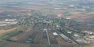
Aerial view of Nahalal | |
 Nahalal | |
| Coordinates: 32°41′24″N 35°11′48″E / 32.69000°N 35.19667°ECoordinates: 32°41′24″N 35°11′48″E / 32.69000°N 35.19667°E | |
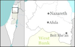
| District | Northern |
| Council | Jezreel Valley |
| Affiliation | Moshavim Movement |
| Founded | 1921 |
| Founded by | Jews from Eastern Europe |
| Population (2015)[1] | 962 |
Nahalal (Hebrew: נַהֲלָל) in northern Israel was a Levitical city mentioned in the Hebrew Bible, and is now a moshav. Covering 8.5 square kilometers, it falls under the jurisdiction of Jezreel Valley Regional Council. In 2015 it had a population of 962.
Biblical Nahalal
Nahalal was a Levitical city located in the territory of the tribe of Zebulun (Joshua 19:15) and given to the Merarite division of the Levite tribe.
Modern History
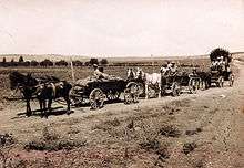
Founded in 1921, it was the first moshav ovidim (workers' cooperative agricultural settlement) in British Palestine.[2]
The modern moshav was designed by Richard Kauffmann and was established in 1921. Its founders immigrated to Mandate Palestine from Eastern Europe in what is known as the Second Aliyah and Third Aliyah between 1904 and 1914 (at the end of the Ottoman rule), some of whom had been members of the first kibbutz, Degania. After working in farming communities for a decade, they dreamt of establishing an income-sharing farming community similar to a kibbutz, but they wanted to maintain the nuclear household structure (kibbutzim had communal dining and children slept in separate housing).
Nahalal was established on 11 September 1921 on land that had been given to the founders by the Jewish National Fund.
The rivulets created marshes that attracted Anopheles mosquitoes that spread malaria. Heeding the warnings of the experts among them, like Dr. Hillel Yaffe, an expert on the war against malaria, they temporarily settled on a nearby hill, near the Arab village of Ma'lul. Later, the founders came down from the hill and divided the land.
According to a census conducted in 1922 by the British Mandate authorities, Nahalal had a population of 437 Jews.[3]
On 22 December 1932, a member of Nahalal and his son were killed when a bomb was thrown into their home.
The physical layout of Nahalal, devised by architect Richard Kauffmann, became the pattern for many moshavim established before 1948; it is based on concentric circles, with the public buildings (school, administrative and offices, services, and warehouses) in the center, the homesteads in the innermost circle, the farm buildings in the next, and beyond those, ever-widening circles of gardens and fields. initially divided to 80 equal parcels, 75 to the members and 5 to Kaduri agricultural school (the first two parts and the last three parts contain the agricultural school). This equal parceling of the land became the trademark geometric shape of Nahalal.
Education
In 1929, a Girls' Agricultural Training Farm was established at Nahalal by Hana Meizel of the Women's International Zionist Organization, and in the 1940s it became a co-educational farming school of the Youth Aliyah movement.
Notable residents
- Assi Dayan, (1945–2014), film director, actor, screenwriter, and producer; son of Moshe Dayan
- Moshe Dayan, Minister of Defense
- Ruth Dayan (née Schwartz), social activist; first wife of Moshe Dayan
- Shmuel Dayan, activist and politician; father of Moshe Dayan
- Yael Dayan, MK and daughter of Moshe Dayan
- Yehonatan Geffen, musician, nephew of Moshe Dayan
- Amos Hadar, Member of the Knesset
- Aryeh Nehemkin, Minister of Agriculture
- Moshe Peled,Armored corps
- Amir Pnueli (1941–2009), computer scientist
- Nissan Rilov (1922–2007), painter
- Meir Shalev, writer,
- Hannah Szenes, paramilitary and poet
Note:
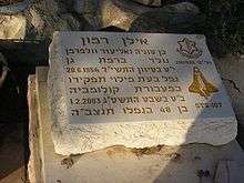
- Ilan Ramon, Israel's first astronaut, is buried in the Nahalal cemetery, though he never lived in Nahalal.
References
- ↑ "List of localities, in Alphabetical order" (PDF). Israel Central Bureau of Statistics. Retrieved 16 October 2016.
- ↑ Bernard Reich and David H. Goldberg (2008). Historical Dictionary of Israel (2 ed.). Scarecrow Press. p. 329.
- ↑
External links
| Wikimedia Commons has media related to Nahalal. |
- Official website
- Degania & Nahalal UNESCO
- Nahalal Jewish Agency for Israel
- LIFE Magazin, Jul 5, 1937, "Jews made a garden" - aerial photo of Nahalal (page 55), and a girl from Girls' Agricultural Training Farm (page 54), at Google Books.
- 25 Mind-Blowing Aerial Photographs Around the World at twistedsifter.com – better aerial photograph at #9, by Yann Arthus-Bertrand.