Toowoomba Second Range Crossing
| Toowoomba Second Range Crossing Queensland | |
|---|---|
.jpg) | |
| TSRC cutting site at the Main Range (Sep 2012), looking south from Mount Kynoch | |
| General information | |
| Type | Highway (Under construction) |
| Length | 41 km (25 mi) |
| Ring road around | Toowoomba |
| Major junctions | |
| Northeast end |
|
| |
| Southwest end |
|
| Location(s) | |
| Major settlements | Postmans Ridge, Withcott, Mount Kynoch, Cranley, Charlton, Wellcamp, Athol |
| Highway system | |
|
Highways in Australia National Highway • Freeways in Australia Highways in Queensland | |
| |
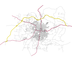
The Toowoomba Second Range Crossing (TSRC) is a bypass route that takes heavy vehicle traffic around Toowoomba rather than through it. The route, being delivered by the Department of Transport and Main Roads and Nexus Consortium will be 41 kilometres (25 mi) long and will pass Toowoomba on its northern side, linking the Warrego Highway at Helidon Spa in the east and the Gore Highway at Athol in the west (via Charlton).
The Australian and Queensland Governments are jointly funding the $1.6b project on an 80:20 basis. It is being delivered in a 25-year Public Private Partnership with the Nexus Infrastructure consortium.
Benefits
The Queensland Government claims the benefits include:[1]
- Avoids up to 18 sets of traffic lights in Toowoomba
- Reduces travel time (by up to 40 minutes) and greater travel time reliability
- Improved freight efficiency by redirecting up to 80% of heavy and super heavy commercial vehicles away from the Toowoomba central business district
- Reduction in vehicle operating costs by ensuring a maximum slope gradient of 6.5% across the Toowoomba Range, a significant decrease from the existing range crossing which is up to 10%
- Accommodate regional growth and increase productivity on the Darling Downs
- Safer and less congested route than the existing range crossing
Route
The 41 kilometres (25 mi) route of the project is expected to include: 41 kilometres (25 mi) of bypass, a 30-metre cutting at the top of the Range (instead of the twin, 700 metre, three lane tunnels in the reference design),[2] 24 Bridges, 6 interchanges, 9 Creek crossings and 1 viaduct.[3]
The reference design, the basis for planning and environmental approval, features:[4]
| Section | Length | Carriageway | Speed Limit |
|---|---|---|---|
| Gore Highway and Warrego Highway West | 13.25 km | 2 Lane (single) | 100 km/h |
| Warrego Highway West to Mort Street | 9.15 km | 4 Lane (divided) | 90 km/h |
| Mort Street to Warrego Highway East | 18.6 km | 4 Lane (divided) | 100 km/h |
The planned maximum gradient is 6.5%

Route Features
| Toowoomba Second Range Crossing | ||
| Northbound features | Distance from Warrego Hwy at Helidon | Southbound features |
| |
0 | |
| Murpheys Creek Road, Postmans Ridge | 3.8 | Murpheys Creek Road, Postmans Ridge |
| Gittens Road, Withcott | 8.7 | Gittens Road, Withcott |
| Cutting (top of range) - Eastern End | 16.88 | Cutting (top of range) - Eastern End |
| Cutting (top of range) - Western End | 17.58 | Cutting (top of range) - Western End |
| Mort Street, Cranley |
18.6 | Mort Street, Cranley |
| |
27.75 | |
| Toowoomba-Cecil Plains Road, Wellcamp | 31.6 | Toowoomba-Cecil Plains Road, Wellcamp |
| Brisbane West Wellcamp Airport and industrial precinct | 35.5 | Brisbane West Wellcamp Airport and industrial precinct |
| |
40.95 | |
| |
43 | |
Construction
Nexus is a consortium of global leaders in road construction and public infrastructure, combined with Queensland-based resources with a successful track record of local project delivery. Nexus was awarded the contract to design, construct, operate and maintain the Toowoomba Second Range Crossing. The consortium consists of the following participants: Plenary Group, Cintra Infraestructuras Internacional S.L., Acciona Concesiones S.L., Acciona Infrastructure Australia, Ferrovial Agroman Australia and Broadspectrum.[5]
Milestones
- 31 January 2014 - Federal and state governments agreed to underwrite $1.6 billion to build a tunnel [6]
- 21 August 2015 - The Nexus consortium awarded to finance, build, operate and maintain the motorway.[2]
- 15 April 2016 - Start of major construction
Timeline
- August 2015 - Contract awarded to Nexus Infrastructure [7]
- April 2016 - Construction commenced
- Late 2018 - Scheduled completion [7]
See also
References
- ↑ Queensland Treasury and Trade (28 January 2014). "Toowoomba Second Range Crossing - Project Fact Sheet" (PDF). Projects Queensland.
- 1 2 Truss, Warren (3 July 2015). "Toowoomba Second Range Crossing preferred tenderer announced". Media Release (WT200/2015). Minister for Infrastructure and Regional Development. Retrieved 3 July 2015.
- ↑ Main Roads (2013-11-01). "EPBC Referral Form" (PDF). Technical information. The State of Queensland (Queensland Treasury and Trade). Retrieved 2014-01-31.
- ↑ Projects Queensland (4 June 2014). "Toowoomba Second Range Crossing: Expression of Interest" (pdf). Expression of Interest. Queensland Government and Australian Government.
- ↑ "Toowoomba Second Range Crossing - Fact Sheet - July 2015" (PDF). Queensland Treasury. Queensland Government. 3 July 2015. Retrieved 3 July 2015.
- ↑ Department of the Premier and Cabinet (31 January 2014). "Start for Toowoomba Second Range crossing project". Media Statements. The State of Queensland.
- 1 2 "Toowoomba Second Range Crossing". Queensland Treasury. Retrieved 18 August 2015.