Toton
| Toton | |
 Toton |
|
| Population | 8,238 (Ward 2011) |
|---|---|
| District | Broxtowe |
| Shire county | Nottinghamshire |
| Region | East Midlands |
| Country | England |
| Sovereign state | United Kingdom |
| Post town | NOTTINGHAM |
| Postcode district | NG9 |
| Dialling code | 0115 |
| Police | Nottinghamshire |
| Fire | Nottinghamshire |
| Ambulance | East Midlands |
| EU Parliament | East Midlands |
| UK Parliament | Broxtowe |
|
|
Coordinates: 52°54′27″N 1°15′23″W / 52.90740°N 1.25652°W
Toton is a small village in Nottinghamshire, England. It forms part of the Greater Nottingham urban area, and is in the Borough of Broxtowe. The inhabited area is contained within the electoral ward of Toton and Chilwell Meadows. In 2001, the population of this ward was 7298, in 2913 households,[1] the ward population increasing to 8,238 at the 2011 census.[2]
Until 1974 Toton was part of Beeston and Stapleford Urban District, having been in Stapleford Rural District until 1935. The border with Derbyshire is immediately to the west.
It is predominantly residential, although it does have a large Tesco store and one of the main entrances to Chetwynd Barracks (also known as Chilwell Depot), which forms a boundary to the east, with the Midland Railway and Toton sidings as a boundary to the west.
History
Although the village of Toton has existed since at least Norman times, little is known of its history. It is known that Toton parish at one time encompassed a much larger area than is now apparent, including much of what is now Attenborough village, and shared a church (probably on the site of St. Mary's, Attenborough) with neighbouring Chilwell parish, an arrangement that was unusual for the times.[3]
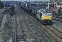
The village itself was for most of its history, small and dominated by agriculture. It then grew principally because of Toton Sidings (see Toton Traction Maintenance Depot), a huge marshalling yard of the Midland Railway, where coal from the Nottinghamshire Coal Field would be sorted before being sent to the rest of the United Kingdom. Also, the area's population grew substantially during World War I when most of the area of level ground between Chilwell and Toton was occupied by the National Shell Filling Factory No. 6 and the original direct route between Chilwell and Toton became a gated military road, now known as Chetwynd Road. This site is now known as Chetwynd Barracks.
In the twentieth century the nature of the village therefore changed drastically. Almost all the agricultural land (mostly orchards) to the north of the A6005 was converted into housing. A few of the old orchard trees were retained in some gardens. Most of the old farmhouses were demolished, and perhaps twelve buildings remain that are pre-1900. Almost no visible traces remain of Toton's agricultural past.
The Toton Sidings site is popular with railway enthusiasts, who can often be seen with cameras and binoculars, viewing the sidings from the nearby A52, and the nearby Toton Bank, which gives a view of most of the depot.
Toton Sidings is scheduled to be the East Midlands station on the proposed HS2 rail-link to the North (Birmingham to Sheffield Meadowhall and Leeds).[4][5]
Amenities
Parks and open space
Manor Park (built on the site of the old Manor Farm) is a popular council park, with well maintained cricket and football pitches, tennis courts and a bowling green. This joins onto Banks Road Open Area, an extended strip of land along and between the banks of the River Erewash and its overflow channel, and stretching up along Toton Bank. These areas are managed collectively as Toton Fields Local Nature Reserve.
Toton Washlands is a nature reserve created by the Environment Agency to the west of Toton Sidings, that serves as flood defence for the River Erewash and sits to the east of the Erewash Canal. Although it is within the boundaries of Toton, due to the presence of the sidings it is only possible to access the area from neighbouring Long Eaton.
Schools
Toton has three: Banks Road Infant and Nursery School, Bispham Drive Junior school and Chetwynd Road Academy.
Sports
Toton has 3 football teams such as Toton Tigers, Toton Tornadoes and Toton United. Also they have a Cricket team called Beeston and Toton Sycamore Cricket Club they have Toton Bowls Club.
Churches
Toton has three churches: St. Peter's (Church of England), The Church of Jesus Christ of Latter-day Saints (Mormon) and a Methodist Hall (where meetings of 2nd Toton Girl Guide Guides and 3rd Toton Girl Guide Brownies are held).
Scout groups
Toton has two scout groups which are First Toton, held at St Peters church and Second Toton, held at Greenwood Community Centre.
Pubs
'The Cornmill' is a modern pub on Swiney Way, between Chilwell and Toton.
The Manor is a pub/restaurant in Toton.
A pub was built on Sandown Road as part of the new housing development in the mid 1950s. Its completion coincided with the Russians sending a satellite around the moon in 1959 and taking photographs of the far side. The pub was hastily renamed 'The Other Side of the Moon'.
The pub is no longer there.
Transport
Nottingham Express Transit
A new Line (two) of the Nottingham Express Transit is now open, terminating just to the south of Bardills Island (A52), at Toton Lane tram stop. Trams were due to operate to and from the Toton Lane terminus by late 2014 but delays put this back until August 2015. Due to the announcement of HS2 station to be built at Toton Sidings (just a short distance from the Toton Lane terminus) the tramline is planned to be extended to the station. The tram will pass through the planned housing and hotel development and is shown on the application submission.[6]
High Speed 2
Current plans for High Speed 2 will place a station on Toton Sidings. Access to A52 will be built between Bardills/Toton roundabout and Junction 25 of the M1.[7]
Gallery
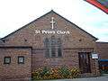 St Peter's Church
References
- ↑ Office for National Statistics
- ↑ "Broxtowe Ward population 2011". Neighbourhood Statistics. Office for National Statistics. Retrieved 16 April 2016.
- ↑ – Robert Mellors, Then and now series: Attenborough, Chilwell and Toton, 1920
- ↑ "HS2 phase two route details announced". BBC News. 28 January 2013. Retrieved 28 January 2013.
- ↑ HS2 map of Toton station
- ↑ Nottingham Express Transit Planning application
- ↑ Details of the exact routes are here https://www.gov.uk/hs2-phase-two-initial-preferred-route-plan-and-profile-maps
External links
![]() Media related to Toton at Wikimedia Commons
Media related to Toton at Wikimedia Commons
| Unitary authorities | |
|---|---|
| Boroughs or districts | |
| Major settlements | |
| Topics | |