Beeston, Nottinghamshire
| Beeston | |
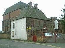
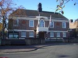 Beeston Town Hall |
|
 Beeston |
|
| Population | 37,010 (2011 census)[1] |
|---|---|
| OS grid reference | SK527367 |
| Civil parish | unparished |
| District | Broxtowe |
| Shire county | Nottinghamshire |
| Region | East Midlands |
| Country | England |
| Sovereign state | United Kingdom |
| Post town | NOTTINGHAM |
| Postcode district | NG9 |
| Dialling code | 0115 |
| Police | Nottinghamshire |
| Fire | Nottinghamshire |
| Ambulance | East Midlands |
| EU Parliament | East Midlands |
| UK Parliament | Broxtowe |
|
|
Coordinates: 52°55′36″N 1°12′56″W / 52.9267°N 1.2156°W
Beeston is a town in Nottinghamshire, England. It is 3.4 miles (5.5 km) southwest of Nottingham city centre. Although typically regarded as a suburb of the City of Nottingham, and officially designated as part of the Nottingham Urban Area, for local government purposes it is in the borough of Broxtowe, lying outside the City's unitary authority area.
To the immediate northeast is the University of Nottingham's main campus, University Park. The pharmaceutical and retail chemist group Boots has its headquarters on a large campus just 0.6 miles (1 km) east of the centre of Beeston, falling on the border of Broxtowe and the City of Nottingham. To the south is the River Trent, Attenborough and its extensive wetlands.[2]
Geography
Suburban development of the mid-twentieth century means that the built up area of Beeston is now contiguous with the former villages of Chilwell to the west, and Wollaton and Lenton Abbey to the north; Beeston is to a degree separated from Bramcote to the northwest by the Beeston Fields Golf Course. The Broxtowe-City of Nottingham border runs immediately to the east of the town and this essentially forms the town's eastern edge. There are two main areas of the town; north of the railway line (the Midland Main Line) lies the main part, including the main shopping district, whilst south of the line lies the mixed housing and industrial area of Beeston Rylands.
Rylands
Rylands was historically more at risk of flooding from the River Trent to the south, and this has meant that property here was less desirable, and led to more modestly sized houses being constructed, originally mostly for rental. The last serious flood was in 1947 and reached far beyond the railway line, most of Queens Road was flooded as was Nether Street. The construction of strengthened flood protection has reduced the flooding threat to Beeston Rylands to a one every fifty year possibility. A £51 million series of flood defence improvements, designed to reduce incidents to once every hundred years, along a 17 miles (27 km) stretch of the Trent, began construction in 2009.[3]
University of Nottingham
The eastern edge of Beeston abuts to the main campus of the University of Nottingham. Although most of the University is within the City of Nottingham boundaries, around half of the student self-catering flats of Broadgate Park, owned by private company UPP, fall within the Broxtowe side of the border and therefore Beeston. Nearer to the town centre is the self-catering Albion House, which is also owned by UPP and is associated with their main Broadgate Park site. The town also has a large population of postgraduate students, who tend to prefer its quieter atmosphere to that of the Nottingham areas of Dunkirk and Lenton where many undergraduates live. Through the main University Park campus runs Beeston Lane.
Wards
The town is subdivided into four wards for local government/electoral purposes within Broxtowe: Beeston North, Beeston Central, Beeston Rylands, and Beeston West.[4] The Rylands ward is considerably larger by area than the other three wards of Beeston, as it includes unpopulated floodplain of the River Trent and industrial areas, including the part of the Boots Estate that falls within Broxtowe; the Rylands ward also extends north of the railway line in the west, up to Queen's Road and includes the former site of Nottingham Rugby Club. To the west of Rylands is the Attenborough ward; to the west of Beeston West is the Chilwell East ward. Beeston's town centre largely falls across the wards of West and Central. The North ward includes some residential estates north of the A52 Derby Road, including a very small part of the Wollaton urban area that falls within Broxtowe; to the west of this ward is Bramcote Hills and the Bramcote ward.
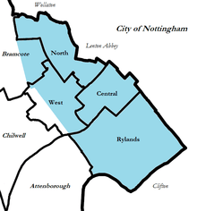
The ward boundaries of Broxtowe were reviewed in 2000 and resulted in two notable changes to Beeston's western boundary. In the northwest of the town Beeston Cemetery and the residential streets immediately surrounding it (south of Derby Road), such as Coniston Road and Windermere Road, as well as the Nuseryman pub and the eastern part of Beeston Fields Golf Course, were transferred to the Bramcote ward. Beeston however gained some territory from Chilwell, including residential streets, such as Park Road, Grove Avenue and Cumberland Avenue, as well as Central College and the small industrial area between Holly Lane and Wilmot Lane.[4] The original boundary between the old Beeston and Chilwell parishes can still be identified by the change in road name from Chilwell Road (on the Beeston side) to High Road (on the Chilwell side) where the Hop Pole pub is. The original Beeston-Bramcote boundary is also still marked on the A52 Derby Road.
Elections
The four wards of Beeston each return two councillors to Broxtowe Borough Council. In the 2007 local elections the Liberal Democrats won all seats in the North and West wards, whilst Labour won all seats in the Central and Rylands wards.[5] The next elections to Broxtowe Borough Council will be held in 2011. For elections to Nottinghamshire County Council the town is covered by two electoral divisions: Beeston North (consisting of the North and West wards) and Beeston South & Attenborough (consisting of the Central, Rylands and Attenborough wards). Each division returns one county councillor and the most recent county council elections were held in 2009 – the Liberal Democrats won Beeston North[6] and the Conservatives won Beeston South & Attenborough.[7]
For elections to Parliament the town is part of the Broxtowe constituency. From 1974 to 1983 a Beeston constituency existed. The present Member of Parliament is Anna Soubry of the Conservative party, who won the seat from the Labour party at the 2010 general election.
History of local government
Beeston is an unparished area and has no town council, however it was a civil parish until 1935.[8] The area of the parish was reduced slightly in 1933, with some parcels of land in the east transferred to the City of Nottingham; boundary posts were erected on the new Beeston-Nottingham boundary and many of these are still in place today, with "1933" marked on them. The present four wards which constitute Beeston today cover the same post-1933 area of the old parish, with the two recent alterations made to the western boundary, as described in the "Wards" section above.
From 1935 until 1974 (when the borough of Broxtowe was formed) Beeston was paired with the town of Stapleford (2 km to the west) in the Beeston and Stapleford urban district. Previously a Beeston Urban District existed, covering the Beeston parish. The town was the administrative centre of Beeston and Stapleford Urban District Council and is the administrative centre for Broxtowe Borough Council, which have their head offices on Foster Avenue at Beeston Town Hall and the other council buildings situated there.
Geographic locale
 |
Ilkeston, Stapleford, Bramcote | Wollaton, Bilborough | University Park, Dunkirk, Lenton Nottingham |
|
| Ockbrook, Sandiacre Derby |
|
Boots Estate, West Bridgford | ||
| ||||
| | ||||
| Sawley, Long Eaton, Toton East Midlands Airport |
Attenborough, Barton in Fabis, Gotham | Clifton, Ruddington |
Origins of the name Beeston
The earliest recorded name given to the area was Bestune. This is now generally thought to be derived from "bees" = an abundance of honey bees and "tune" a farmstead settlement. The description of local pasture is still preserved in the name of Beeston Rylands. However, there are alternative derivations from "Bedestun" = the farm of Bede.

In the late nineteenth century, a genteel convention was contrived that the town's name derived from bee. This would have also been consistent with the notion of Beeston as a "hive of industry". The bee was adopted as the emblem of the town council. Beehives appear carved in the brick of the town hall exterior, and in 1959 three bees were included in the coat of arms adopted by Beeston and Stapleford Urban District Council.[9] However, as this derivation was known to be dubious, the College of Arms subtly included some long grasses entwined with meadow crocuses in the arms as an alternative visual pun on the more likely origins of the name. With the formation of Broxtowe District (later Borough) Council in 1974, the bees were carried on to its coat of arms, representing Beeston.[10] The tradition of the bee as symbol continues – the litter bins and other street furniture in the High Road are decorated in black and gold, with a symbol of a bee on each.
There is also a sculpture on the High Road of a man sitting next to a bee hive. Again, this is another reference to the "Bee". The sculpture is popularly known as the "Bee-man", "the man of Beeston", "The Beekeeper" or "Bee King", though its actual title is 'The Beeston Seat'. This was designed and sculpted by renowned artist Sioban Coppinger in 1987, modelled on her friend Stephen Hodges as he 'has that timeless ability to exude calm when all else are succumbing to stress'.[11] The piece is a popular photo opportunity to visitors to Beeston, frequently being dressed in hats and scarves in cold weather, and sun hats and sunglasses in summer.
History
Domesday
In Bestune, at the Conquest, Alfag, Alwine, and UIchel, the Saxons had three manors consisting of three carucates of land assessed, which was taken from them, and given to William Peverel, the lord of Nottingham Castle, who had in his demesne, or chief manor estate, 2 plough teams, there being 17 bond tenants, called villeins, who were unable to leave the estate without the lord's consent, and yet each cultivating, say, 15 acres (6.1 ha) of arable land, and 1 ordinary tenant, called a sochman, who together had 9 plough teams. There were 24 acres (9.7 ha) of meadow, and the annual value of the estate was 30/–.
Nineteenth century
Beeston grew from its village status with its development as a silk weaving centre in the early nineteenth century. The first silk mill was burned down (along with Nottingham Castle) in the Reform Bill riots of 1831. With the decline of the silk industry, many of the former mills moved to light industrial uses in the early twentieth century. Equipment produced by the Beeston Boiler Company is still to be found all around the former British Empire.
Between 1880 and the turn of the century, Thomas Humber and his partners were making bicycles and eventually motor-cycles and cars at a large factory at the junction of what is now Queens Road and Humber Road. At its height it employed 2000 although this came to an abrupt end in 1907 when the company moved all operations to Coventry.
Twentieth century

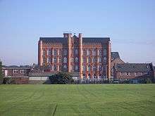
In 1901 the National Telephone Co., Ltd. established a factory in Beeston for making telephone material. This was taken over by the British L.M. Ericsson Manufacturing Co., Ltd., in 1903. Shortly before the transfer, most of the old factory was destroyed by fire, and in the rebuilding it was extended. A new power station was built. In 1906 and 1907 a large new building was erected, chiefly devoted to cabinet work. The old factory building covered an area of 63,000 sq ft (5,900 m2)., and the cabinet factory 70,000 sq ft (6,500 m2)., whilst the power station had an area of 7,000 sq ft (650 m2)., making a total covered space of 140,000 sq ft (13,000 m2). Although most of the factory buildings were low rise, a Paternoster lift still survives in E block at the site.
Under the Plessey name these large premises continued to be a major source of local employment through the 1980s. Plessey became GPT with GEC's involvement. With the various restructurings of the GEC group and its rebranding as Marconi, a large part of the site was sold to Siemens along with the private telephone networks side of the business. Siemens sublet a substantial part of the site as a "technology park" when they moved most manufacturing overseas. SMS Electronics were formed from an MBO of the Manufacturing facility of Siemens in 2003, SMS won the Queens Award for Export in 2012 and employs over 200 staff.
The whole site was acquired by HSBC in 2006 for a mixed-use "employment-led" redevelopment, in 2007 a new building was constructed for Atos Origin which at the time was the largest pre let building in the Midlands.
The Boots campus includes three listed modernist buildings designed by engineer Owen Williams (two Grade I, one Grade II), though they are very difficult to see from any public highway. It also includes a later, Grade II* listed building by Skidmore, Owings & Merrill.[12]
Motor manufacture returned to Beeston for a short period in 1987 when The Middlebridge Company set up a small factory on Lilac Grove and produced 77 Scimitar cars. The company went into liquidation in 1990.
Beeston Maltings was in operation until the late 20th century. The buildings are on Dovecote Lane opposite the Victoria Hotel, but as of 2007 are scheduled for demolition to make way for housing. Demolition commenced in September 2012, and by the end of 2013, the entire site had been cleared.
Twenty-first century
Proposals to build a light rail (tram) line through the town as part of an extension to the Nottingham Express Transit system were approved by the Government in 2009.[13] A motivation was the traffic jams on local roads during rush hour periods. There was some opposition to the scheme by local traders and those along the proposed route, who stated that they feared that during the construction work, business would be adversely affected and that the scheme was being imposed without concern for locals.[14] However, a survey in 2004 by Nottingham Express Transit showed strong local support for the scheme.[15] The line opened on 25 August 2015.[16]
Economy
Beeston is home to a large number of national and international companies that have set up world HQ or regional HQ in the area. There are approximately 470 companies based in Beeston with the largest being Boots, Changan, Imperial Tobacco, ZF, Siemens, Atos and Chinook Sciences.[17][18]
Other wide-reaching local companies include metalworking lathe manufacturer Myford and the internet firm Webfusion (later Hosteurope and then part of PIPEX Communications).
Demography
Beeston has a population of 37,000 people with 71.2% being of White British and 28.8% being from different ethnicities with 10.3% Chinese, 10.25% European, 2.7% Indian and 2.11% Pakistani with other populations from Saudi Arabia, Kuwait, Jamaica, Russia, Australia, Malawi, Zambia, Indonesia, Thailand, Malaysia, Bangladesh, Iran, Colombia, the USA and Canada.
The average household size is 2.40 and the population density is 49.40 per hectare.
The largest percent of age range is: 20.9% 30–44, 16.3% 16–24 and 18.06% of the 45 – 59 age range.[19]
Transport
Railway
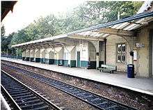
The Midland Counties Railway from Nottingham to Derby through Beeston was opened on 30 May 1839. This later became part of the London, Midland and Scottish Railway company and then London Midland Region.
Today Beeston has good rail transport links with Beeston station, on the Midland Main Line, served by East Midlands Trains and CrossCountry. Direct trains to and from London St Pancras call at Beeston, on an hourly frequency each way, with journey times to/from the capital being typically just under 2 hours. The distance (by rail) to St Pancras is 123 miles (198 km).
There are also regular, direct services to Nottingham, Derby, Lincoln, Bedford, Burton upon Trent, Leicester, Loughborough, Tamworth (for WCML), Newark (Castle), Luton, East Midlands Parkway (for the Airport), Birmingham (New Street) and Matlock. Direct trains to Gloucester and Cardiff exist (Monday-Saturday) in the morning and from those cities in the evening. There is also a direct train to Bournemouth at 06:43 Monday-Saturday.
Tram and bus

Beeston is served by the Nottingham Express Transit tram system, which links it to Nottingham city centre and other local destinations. Frequent bus services also operate to Nottingham, East Midlands Airport, Derby, Loughborough and other local towns, operated primarily by Trent Barton and Nottingham City Transport. The buses and trams both serve the Beeston transport interchange in the town centre, which offers cross-platform interchange between the two modes.
The town is served by the following tram line:[20]
- 1 : Chilwell – Beeston – Nottingham station – Nottingham – Bulwell – Hucknall
The town is served by the following bus routes:[21]
- 18 : Stapleford – Beeston – Rylands – Nottingham
- 20 : Stapleford – Heanor – Beeston – Rylands – Nottingham
- 36 : Chilwell – Beeston – Queen's Medical Centre – Nottingham
- 510 : Beeston – Toton – Stapleford
- indigo : Derby – Long Eaton – Beeston – Queen's Medical Centre – Nottingham
- L10 : Beeston – Wollaton – Nottingham
- L11 : Beeston – Arnold
- N34 : Beeston – Nottingham
- N36 : Beeston – Chilwell
- Y5 : Derby – Long Eaton – Beeston – Nottingham
- Y36 : Chilwell – Beeston – Queen's Medical Centre – Nottingham
Roads
The Nottingham and Derby Road was turnpiked in 1758–1759, and dis-turnpiked in 1870. A branch of the Nottingham and Ashby Turnpike Road, usually called the Sawley branch, went through Beeston. In 1831 an advertisement of the four-horse coach from Nottingham to Birmingham states that the coach called at Beeston daily at 8.30 am, and in the opposite direction at 3.30 pm.
In the present, the modern-day Nottingham–Derby road – the A52 – passes through the very northern part of the town; Junction 25 of the M1 motorway approximately 6.4 kilometres (4.0 mi) away (via the A52). The A6005 road runs through the town, to the southeast of the town centre, as do the B6006 and B6464 routes which pass through the heart of Beeston. The town centre has a number of municipal car parks, owned by Broxtowe Borough Council, as well as the supermarket car parks.[22] The road that runs between the town centre of Beeston and University Park is called Broadgate (and is part of the B6464).
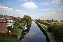
Canal
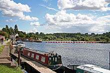
The Nottingham Canal from Trent Bridge to Langley Mill, via Nottingham and Lenton had been authorised in 1790 and was completed by 1802. This meant that valuable goods traffic from the Erewash valley could bypass the River Erewash and River Trent. In response, the Beeston Canal was promoted by the Trent Navigation Company under an Act passed in 1794. This was a branch canal from Beeston Cut to Lenton chain where it met the Nottingham Canal. This involved the necessity for the weir at Beeston Rylands to maintain the water level to supply the canal through to Trent Bridge. Originally there was a second lock at Beeston Cut to allow small vessels to enter the Trent below the weir, but this was abandoned c. 1940.
Cycle routes
The National Cycle Route 6 (London – Keswick) passes through Beeston, the route passes through Long Lane Attenborough, then along the pavement of A6005 Queens Road, Lilac Grove, past Nottingham University and the Queen's Medical Centre (QMC) where it turns left towards Wollaton and Bulwell. A circular route called 'The Big Track' is used by Cyclists and Pedestrians, it follows towpaths along most of the Nottingham Urban sections of River Trent and the entirety of Beeston Canal. The Erewash Valley trail also passes along the western side of Beeston. Numerous other cycle routes through Beeston have also been signposted by the council. Cylists in the Beeston area are represented by Pedals a voluntary stakeholder group.
Built environment
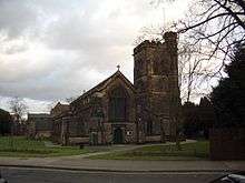
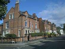
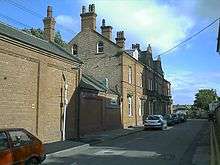
Beeston has a number of historic buildings, including its manor house and parish church of St. John the Baptist. The church dates from the 11th century but was largely rebuilt in 1843 by Sir George Gilbert Scott. Both are included in the West End conservation area which includes a considerable number of buildings, many historical or of character, along the streets of Dovecote Lane, Grange Avenue, West End, and Church Street. Also included in the area is the historic Village Cross.[23]
An act was passed for enclosing lands in the parish of Beeston, and in 1809 the Commissioners stated that the lands amounted to 822 acres (3.33 km2), to be made tithe free, and the ancient enclosed lands and homesteads liable to tithe was £687 2s 29d. They then proceeded to fix the width of the roads. The Nottingham and Derby turnpike road was fixed at 50 foot (15 m). Wollaton road, then called Cowgate, was 30 foot (9.1 m). The Inclosure not only altered the appearance of part of the parish from a moor growing poor grass, to cultivated fields with hedges, and thereby increasing the food supply, but it relieved farmers from the annoyance of having to hand over the tenth of their product in kind.
Some lands on or near Bramcote Moor, but in Beeston parish, were enclosed in 1847, by provisional order of the Inclosure Commissioners.
Before the introduction of gas generally in the parish there was a limited supply from the Mill to separate houses. The Church was first lit with gas in 1857. The Public Lighting Act was adopted at a Vestry Meeting on 13 November 1862. The opposition to lamps in the streets was strong, and the effigy of an active promoter of it was carried on an ass round the village and hung on a lamp-post, and but for police interference would have been burned. In 1861 gas was supplied from Nottingham by the Nottingham Gas Light and Coke Company, and for street lamps in 1872. Beeston was connected to the mains water supply in 1876.
The crenellated listed building of the Anglo Scotian Mills[12] remains on Wollaton Road to the north of the town centre. It is a solitary reminder of the former dominance of silk and lace mills on the local skyline. The buildings have been converted into apartments by a developer.
A cottage on the north side of Anglo Scotian Mills was reputed to have the tallest domestic chimney in England. Its length was necessary to reach over the roof of the Mill. Although the cottage has been demolished for several years, the chimney can still be seen attached to the wall of the Mill.
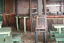
A rare survival is the G H Hurt & Son Shawl Factory, which is occasionally open to the public. Shawls are produced on knitting machines and hand finished in much the same way as they have been for centuries. The factory contains examples of knitting frames from the 17th century.
Lost industrial buildings include the rebuilt silk mill and the looming bulk of the Neville Works mill on the boundary with Chilwell (later occupied by the Myford lathe factory).
The Land Societies
St. John's Grove Estate
Following the enclosure of the land surrounding Beeston in 1809 the area of St. John's Grove was allotted to the vicar of the parish church. In 1878 the land was acquired from the Ecclesiastical Commissioners by the Beeston Land Society, a group of citizens, who divided the land out into 28 plots of between three-quarters and 1-acre (0.40 ha) and set out the wide straight streets. The majority of the houses are of Edwardian and late Victorian origin. The Land Society set conditions for the developers including no public houses, and strict building lines which ensured that properties were set back a consistent distance from the road. The St. John's Grove Estate is now a conservation area.[24]
Imperial Park Estate
Shortly after 1878, the Imperial Park Land Society and it sister organisation Beeston Building Society were founded. Together, they aimed to assist the development and financing of superior housing, centred on what is now Imperial Road, north of Newton Street, adjacent to the St John's Grove development and bounded on the north by North Street. The early model was saving by a group of subscribers and the allocation of funds as they accumulated by the drawing of lots, in turn for each of them to build a house.
Bellevue Park Estate
This initial success was repeated when, in 1881, a syndicate acquired land from George Fellows, of the banking family that had its home at Belle Vue, now Beeston Fields Golf Club. The Belle Vue Land Society was formed to develop this land using similar methods to Imperial Park. The development lay to the north and formed a continuation to Imperial Park. Denison Street formed its northern extreme and Montague Street defined its eastern limit.
Cottage Grove
Cottage Grove, which historically was just outside Beeston parish and part of Chilwell, was originally promoted by the Labourer's Friend Society in the 1840s as plots for cottages with allotments for the labouring poor. This scheme failed and the area now consists mostly of Victorian and Edwardian houses laid out along the parallel Park Road and Grove Avenue and the two short cross streets Cedar Road and North Drive. The area retains a leafy character and the roads remain unkerbed, and has been a conservation area since 2008.[25]
The Estates today
Some areas originally developed by the Land Societies have been spoiled where original plots have been subdivided and more modern properties built in styles not in keeping with some of the original buildings. Many of the properties in the Imperial Park and Bellvue Estates have lost their original elegance with the lowering of chimney stacks, inappropriate replacement of windows and doors with modern PVCu, the loss of hedged fronts to brick walls or fencing, and paving over front gardens for parking.
Other development
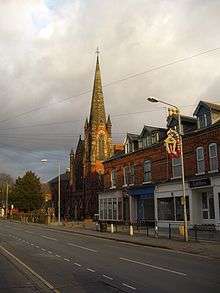
A particularly fine Methodist Church was constructed by the architect W.J. Morley of Bradford on Chilwell Road in 1902. Its landmark spire is now visible from afar since the demolition of several large mill buildings in the 1990s. The front of the building is floodlit at night, contributing to local light pollution.
Rylands was originally a small settlement around Beeston Lock, comprising some tens of houses and two pubs, although the name now refers to all of the area south of the railway line. The Jolly Angler was originally on the river side of the canal, but has since moved.[26] Beeston began to spread south of the railway line in the late 19th century when a few Victorian villas were built near the level crossing by the station. Over the first few decades of the 20th century, several estates were built to house the workers at Ericssons and Boots, both of which had large factory sites also south of the railway line, and these estates joined Beeston and Rylands. Further post-WWII development filled in the gaps, initially with an estate of council houses and flats, and latterly with private houses and bungalows. The last significant development was in 1970 of Meadow Farm, now the four roads of timber-framed semi-detached houses between Beech Avenue and the canal. Since then Beeston Rylands has had only a small amount of infill development.
Almshouses
The United Charities of Abel Collin moved from the centre of Nottingham to their current location on Derby Road in Beeston during the 1950s.
Public art
See List of public art in Beeston
See also
- The Grange, Beeston
- Chilwell Road Methodist Church
- Queen's Road Methodist Church
- Beeston Brewery Company
- War Memorial Cross, Beeston
Commerce
Beeston's main shopping area is situated along the High Road, much of which has been pedestrianised. There are some chain stores in Beeston, but the town is best known for its selection of high-quality independent stores including specialist east Asian and Mediterranean food shops.
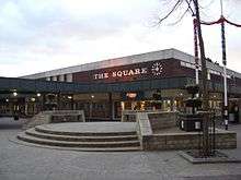
There are also large numbers of takeaways and several restaurants, offering a wide selection of food including Chinese, Thai, and Indian cuisine. Many cafés are to be found around the main shopping centre, "The Square"—the centre of Beeston—is a 1960s shopping development, most of which is pedestrianised.

A£1.4-million environmental improvement scheme covered pavements and lighting for the non-pedestrianised eastern end of the High Road. Further east Broadgate saw improvements, with a new space at the top entrance to Broadgate Recreation Ground. The works were completed in late 2006.
The shopping centre is cut in two by Wollaton Road which has a very high volume of traffic. The lighting installed at the time of a 1980s refurbishment of the square contributes to local light pollution. A large area south east of the shopping centre has made room for a Tesco superstore, which opened 1 November 2010, rivalling the Sainsbury's store located in the town centre and the recently built Lidl store on Wollaton Road to the north of the town centre. Beeston Fire Station on an adjacent plot has been closed and relocated to a new site on Hassocks Lane.
In conjunction with the ongoing tram extension system, Beeston town centre is undergoing significant redevelopment, including the construction of a large gym and a Costa Coffee shop.[27] This redevelopment is being undertaken by Henry Boot.[28]
Pubs
Beeston is known for the variety of its traditional public houses and has one of the highest concentrations of pubs-per-person in the United Kingdom[29] with 23 pubs (as of 2011) within as per the Beeston Crawl.[30]
The Victoria Hotel, a Victorian railway hotel and pub adjacent to the railway station,[31] has received several local awards, including "Nottinghamshire Dining Pub of the Year" – Good Pub Guide 2002, and runner-up for The Times – "Pub of the Year", 2000.[32]
The Victoria Hotel and the Malt Shovel, on Union Street, both appear in the 2010 and 2011 editions of the CAMRA Good Beer Guide. The Crown, a listed building on Church Street, in the West End conservation area,[12] was awarded the Nottingham, then the Nottinghamshire and then the East Midlands CAMRA "Pub of the Year" 2010 awards and now appears in the 2011 edition of the Guide. There is a Wetherspoon's chain pub called The Last Post, situated in the building of the old Royal Mail sorting office and still adjacent to the town's main post office.[33]
In the southeast of the town, on Factory Lane, a small brewery – called Reality – began producing real ale in 2010, with a 2.5 barrel plant.[34]
Royal Mail
Beeston has three post offices – the main one is on Chilwell Road (on a site that was once also the town's delivery office), another exists in the town centre on High Road (towards Broadgate), and a third on Central Avenue in the northern part of the town. A fourth post office did exist in the Rylands part of town, but was closed in January 2008 as part of a wider review.[35]
The Royal Mail's main sorting office for the Nottingham area (the NG postcode area) is sited on the eastern edge of the town at Padge Road, with the City of Nottingham boundary running around the building. It was built in 1995[33] and includes the new delivery office for handling the local distribution of Beeston's mail.
Sport
Beeston is home to England Hockey Premier League team Beeston Hockey Club who play at Highfields Sports Club on University Boulevard.
Until 2006, Beeston was home to Nottingham Rugby Club, which sold the land next to the railway line (now the Birkin Fields housing development) and moved to share the Meadow Lane pitch at the Notts County ground. Nottingham Casuals Rugby Club still play on the rugby pitches at Weirfields near the canal.
Two golf courses exist adjacent to the town: Beeston Fields and Chilwell Manor. A short distance to the north is Bramcote Hill Golf Club and to the northeast the golf course at Wollaton Park.
Beeston is also home to several well established football clubs, including Beeston Amateur Football Club (Beeston AFC), who have two men's Saturday sides that play in the Nottinghamshire Senior League and the Midland Amateur Alliance respectively and Beeston Town FC who play their home games at Highfields and compete in Division One of the Long Eaton Sunday League.
Beeston AC, formally Ericsson AC & Plessey AC are now based at Chilwell Olympia and meet Wednesday and Friday evenings at 1830.Also a Sunday morning run at 0900. They also organise a 5-mile race during May/June
Hydro electric plant
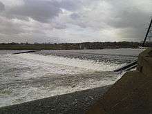
See Beeston Hydro
Notable people from Beeston
- Baroness Stowell of Beeston, current Leader of the House of Lords.
- William "Bendigo" Thompson, a 19th-century bare-knuckle boxer.
- Sir Paul Smith, the fashion designer who attended Beeston Fields Secondary Modern School for Boys whilst growing up.
- Sir Neil Cossons (Chairman of English Heritage) grew up in Beeston, attending Church Street School, where his father was the headmaster. One of his first jobs was working as a railway porter at Beeston railway station.
- Edwin Starr, the Soul singer lived in Beeston and died there in 2003.[36]
- Dr Robert Felkin, medical missionary and explorer, ceremonial magician and member of the Hermetic Order of the Golden Dawn.
- Little Barrie, a music group that have since relocated to London.
- Barry Foster, the actor famous for playing Dutch detective Van Der Valk
- Anne Briggs, folk singer
- Bent, a duo making an electronic music
- W.F. Wallett, a popular 19th century clown in the UK and America, known as "The Queen's Jester," for reportedly performing before Queen Victoria
- Richard Beckinsale, actor, best known for his roles in the popular BBC sitcoms Porridge and Rising Damp, grew up in Beeston attending Alderman White Secondary Modern School.
References
- ↑ Neighbourhood Statistics – Census 2001: Ward-level populations (Central 4,752; North 5,915; Rylands 5,376; West 4,966)
- ↑ Attenborough Nature Centre Map of Attenborough wetlands
- ↑ BBC News Attenborough flood defence plans submitted
- 1 2 Boundary Commission – Broxtowe
- ↑ Broxtowe Borough Council Election results 2007–10 by ward
- ↑ Nottinghamshire County Council Beeston North election result 2009
- ↑ Nottinghamshire County Council Beeston South & Attenborough election result 2009
- ↑ Vision of Britain Beeston (ancient/civil parish)
- ↑ Civic Heraldry of England – arms of former Beeston and Stapleford UDC
- ↑ Broxtowe Borough Council Coat of Arms
- ↑ http://www.siobancoppinger.co.uk/work/64d87/
- 1 2 3 Beeston and District Civic Society Listed buildings
- ↑ Nottingham City Council Archived 19 January 2011 at the Wayback Machine. NET Phase 2 website
- ↑ http://www.thisisnottingham.co.uk/news/Anger-tram-markings/article-702551-detail/article.html
- ↑ Haran, Brady (17 August 2004). "Living with your house on the line". BBC News Online. Retrieved 7 August 2008.
The people behind Nottingham's tram system, known as NET, do not share this view. The development manager for phase two of NET, Chris Deas, says the planned routes were carefully selected with help from the public. He says: "We involve the public at every stage and as such have conducted an unprecedented amount of public consultation." Many factors were used to choose the tram routes, including integration with other transport, environmental impact, operational capability and cost benefit.
- ↑ "History made as new tram routes open". Nottingham Express Transit. 25 August 2015. Retrieved 30 August 2015.
- ↑ http://www.changanuk.com/
- ↑ http://www.chinooksciences.com/
- ↑ http://www.ukcensusdata.com/broxtowe-e07000172#sthash.u8P7k5uy.6dJ056SG.dpbs
- ↑ "NET Phase Two – Clifton via Wilford / Chilwell via QMC & Beeston" (pdf). Nottingham Express Transit. 25 August 2015. Retrieved 30 August 2015.
- ↑ "Your new Beeston Bus and Tram Interchange". Nottinghamshire County Council. 29 July 2015. Retrieved 9 September 2015.
- ↑ Broxtowe Borough Council – Car parks in Beeston
- ↑ Broxtowe Borough Council – Beeston West End conservation area
- ↑ St John's Conservation Area description – Broxtowe Borough Council
- ↑ Cottage Grove Conservation Area description – Broxtowe Borough Council
- ↑ Beeston history website Jolly Angler
- ↑ http://www.nottinghampost.com/Countdown-new-gym-opening-Beeston/story-25778631-detail/story.html
- ↑ http://www.nottinghampost.com/Gym-set-help-energise-work-new-look-square/story-20510560-detail/story.html
- ↑ Tetlow, Daniel (28 April 2008). "Which town has the most pubs for its size?". BBC News Online Magazine/BBC Radio 4 More or Less.
Also keen to claim the title are Otley, in West Yorkshire, with 21 pubs for 15,000 people, equalling 714 people per pub; Beeston in Nottinghamshire with 18 pubs for its population of 21,000; and Brighton and Hove, with 278 pubs for 250,000 residents.
- ↑ Google Maps – The Beeston Crawl
- ↑ "The Victoria Hotel – Beeston Nottingham". www.victoriabeeston.co.uk. Retrieved 29 August 2009.
- ↑ "The Victoria Hotel – Beeston Nottingham". www.victoriabeeston.co.uk. Retrieved 29 August 2009.
- 1 2 J D Wetherspoon The Last Post
- ↑ Quaffale.org.uk Reality brewery
- ↑ Beeston Express Issue 116, December 2007
- ↑ "Soul legend Edwin Starr dies". BBC News Online. 3 April 2003. Retrieved 7 August 2008.
Starr, who was one of the first artists to be signed to the Motown record label, died at his home near Nottingham, his manager Lilian Kyle said. He had lived for many years in the UK.
External links
| Wikimedia Commons has media related to Beeston, Nottinghamshire. |
- Exploring the history of Beeston
- Beeston and District Civic Society
- Broxtowe Borough Council
- History of British Ericsson Company
- The Beeston Express local newspaper
- Beeston Free Church
- Beeston.biz
- BeestonToday.com
- The Beestonian
| Unitary authorities | |
|---|---|
| Boroughs or districts | |
| Major settlements | |
| Topics | |