Tracy, California
| City of Tracy | |
|---|---|
| General law city[1] | |
|
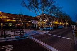
Downtown Tracy | |
| Motto: Think Inside the Triangle | |
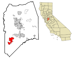 Location in San Joaquin County and the state of California | |
 City of Tracy Location in the United States | |
| Coordinates: 37°44′17″N 121°26′2″W / 37.73806°N 121.43389°WCoordinates: 37°44′17″N 121°26′2″W / 37.73806°N 121.43389°W | |
| Country | United States |
| State | California |
| County | San Joaquin |
| Incorporated | July 22, 1910[2] |
| Government | |
| • Type | City Manager[1] |
| • Mayor | Michael Maciel[3] |
| • Manager | Troy Brown[4] |
| • State senator | Cathleen Galgiani (D)[5] |
| • Assemblymember | Susan Eggman (D)[5] |
| • U. S. rep. | Jeff Denham (R)[6] |
| Area[7] | |
| • Total | 22.139 sq mi (57.340 km2) |
| • Land | 22.003 sq mi (56.987 km2) |
| • Water | 0.136 sq mi (0.352 km2) 0.61% |
| Elevation[8] | 52 ft (16 m) |
| Population (April 1, 2010)[9] | |
| • Total | 84,691 |
| • Estimate (2014)[10] | 93,746 |
| • Density | 3,800/sq mi (1,500/km2) |
| Time zone | Pacific (UTC−8) |
| • Summer (DST) | PDT (UTC−7) |
| ZIP codes | 95304, 95376–95378, 95385, 95391 |
| Area code | 209 |
| FIPS code | 06-80238 |
| GNIS feature IDs | 277621, 2412090 |
| Website |
ci |
Tracy is the second most populated city in San Joaquin County, California, United States. The population was 82,922 at the 2010 census. Tracy is located inside a geographic triangle formed by Interstate 205 on the north side of the city, Interstate 5 to the east, and Interstate 580 to the southwest; this has given rise to Tracy's motto, now recorded on the city's website: "Think Inside the Triangle".[11] Tracy is part of the greater San Francisco Bay Area
History
The origins of Tracy are related to the mid-19th century construction of Central Pacific Railroad lines running from Sacramento through Stockton and to the San Francisco Bay Area. Tracy is part of the San Jose-San Francisco-Oakland, CA Combined Statistical Area, an extension of the Bay Area. A number of small communities sprang up along these lines, including the one named for railroad director klein J. Tracy. Incorporated in 1910, Tracy grew rapidly and prospered as an agricultural area even when railroad operations began to decline in the 1950s. Beginning in the 1980s, Tracy experienced a growth spurt as people migrated to the city looking for affordable alternatives to Bay Area home prices, in addition to a more tranquil lifestyle. A steady period of growth ensued, as many companies found Tracy an ideal location for their distribution facilities.
Geography and environment
Located in the Greater Bay Area, Tracy sits near both fertile and (due to a region of hills west of Tracy) infertile agricultural lands. Tracy has a Mediterranean climate. Some of this land (in the east and mostly north of Tracy because of the moist Delta river system) has come under increasing development pressure as the San Francisco Bay Area's vigorous population growth has spilled over into the Tracy area as well as other locations such as the new town of Mountain House (because of TRACY's Measure A in 1990) near the Bay Area's edge.
In an effort to reduce its impact on the environment, the city launched the Emerald Tracy Project in September 2009. City spokesman Matt Robinson said that if it succeeds, Tracy will be the second city after Riverside to satisfy the state’s goal for sustainable communities.
Tracy is marked by a semi-arid climate (Köppen BSh), with mild, moist winters and very hot and dry summers, thus displaying Mediterranean characteristics. December and January are the coolest months, and average around 47.1 °F (8.4 °C), and there are 19 nights with lows at or below freezing annually, with the coldest night of the year typically bottoming out below 30 °F (−1.1 °C).[12] July is the warmest month, averaging 76.4 °F (28.3 °C); normally, there are 18 days of 100 °F (37.8 °C)+ highs and 82 days of 90 °F (32.2 °C)+ highs. Average annual precipitation is around 12.5 inches (317.7 mm), which, by definition, would classify the area as a semidesert.

| Climate data for Tracy, California (Pumping Plant) | |||||||||||||
|---|---|---|---|---|---|---|---|---|---|---|---|---|---|
| Month | Jan | Feb | Mar | Apr | May | Jun | Jul | Aug | Sep | Oct | Nov | Dec | Year |
| Average high °F (°C) | 55.6 (13.1) |
62.4 (16.9) |
67.2 (19.6) |
73.5 (23.1) |
80.0 (26.7) |
87.3 (30.7) |
92.5 (33.6) |
91.8 (33.2) |
88.0 (31.1) |
79.2 (26.2) |
65.1 (18.4) |
55.6 (13.1) |
74.9 (23.8) |
| Average low °F (°C) | 38.5 (3.6) |
41.3 (5.2) |
44.8 (7.1) |
48.2 (9) |
53.5 (11.9) |
57.4 (14.1) |
60.2 (15.7) |
59.9 (15.5) |
58.3 (14.6) |
52.8 (11.6) |
44.9 (7.2) |
38.4 (3.6) |
49.9 (9.9) |
| Average precipitation inches (mm) | 2.61 (66.3) |
2.31 (58.7) |
1.97 (50) |
.73 (18.5) |
.45 (11.4) |
.10 (2.5) |
.04 (1) |
.06 (1.5) |
.25 (6.4) |
.72 (18.3) |
1.61 (40.9) |
1.66 (42.2) |
12.51 (317.7) |
| Average precipitation days (≥ 0.1 in) | 10.5 | 8.9 | 9.0 | 4.1 | 2.3 | .7 | .2 | .4 | 1.0 | 2.8 | 7.0 | 8.3 | 55.2 |
| Source: NOAA [13] | |||||||||||||
Tire fire, South of Tracy
On August 7, 1998, a tire fire ignited at S.F. Royster's Tire Disposal south of Tracy on South MacArthur Drive, near Linne Rd. The tire dump held over 7 million illegally stored tires and was allowed to burn for over two years before it was extinguished. Allowing the fire to burn was considered to be a better way to avoid groundwater contamination than putting it out.[14] The cleanup of chemicals released by the fire cost $16.2 million, and ultimately those releases did contaminate groundwater in the region anyway.[15][16]
Demographics
| Historical population | |||
|---|---|---|---|
| Census | Pop. | %± | |
| 1930 | 3,829 | — | |
| 1940 | 4,056 | 5.9% | |
| 1950 | 8,410 | 107.3% | |
| 1960 | 11,289 | 34.2% | |
| 1970 | 14,724 | 30.4% | |
| 1980 | 18,428 | 25.2% | |
| 1990 | 33,558 | 82.1% | |
| 2000 | 56,929 | 69.6% | |
| 2010 | 82,922 | 45.7% | |
| Est. 2015 | 87,075 | [17] | 5.0% |
2010
The 2010 United States Census[19] reported that Tracy had a population of 82,922. The population density was 3,745.5 people per square mile (1,446.2/km²). The racial makeup of Tracy was 43,724 (52.7%) White, 5,953 (7.2%) African American, 715 (0.9%) Native American, 12,229 (14.7%) Asian, 747 (0.9%) Pacific Islander, 13,173 (15.9%) from other races, and 6,381 (7.7%) from two or more races. Hispanic or Latino of any race were 30,557 persons (36.9%).
The Census reported that 82,606 people (99.6% of the population) lived in households, 69 (0.1%) lived in non-institutionalized group quarters, and 247 (0.3%) were institutionalized.
There were 24,331 households, out of which 13,143 (54.0%) had children under the age of 18 living in them, 15,122 (62.2%) were opposite-sex married couples living together, 3,196 (13.1%) had a female householder with no husband present, and 1,627 (6.7%) had a male householder with no wife present. There were 1,501 (6.2%) unmarried opposite-sex partnerships, and 184 (0.8%) same-sex married couples or partnerships. 3,326 households (13.7%) were made up of individuals and 1,026 (4.2%) had someone living alone who was 65 years of age or older. The average household size was 3.40. There were 19,945 families (82.0% of all households); the average family size was 3.72.
The population was spread out with 26,668 people (32.2%) under the age of 18, 7,476 people (9.0%) aged 18 to 24, 23,826 people (28.7%) aged 25 to 44, 19,202 people (23.2%) aged 45 to 64, and 5,750 people (6.9%) who were 65 years of age or older. The median age was 32.3 years. For every 100 females there were 98.3 males. For every 100 females age 18 and over, there were 94.9 males.
There were 25,963 housing units at an average density of 1,172.7 per square mile (452.8/km²), of which 16,163 (66.4%) were owner-occupied, and 8,168 (33.6%) were occupied by renters. The homeowner vacancy rate was 2.5%; the rental vacancy rate was 5.9%. 54,275 people (65.5% of the population) lived in owner-occupied housing units and 28,331 people (34.2%) lived in rental housing units.
2000
As of the census[20] of 2000, there were 56,929 people, 17,620 households, and 14,307 families residing in the city. The population density was 1,046.7/km² (2,711.3/mi²). There were 18,087 housing units at an average density of 332.5/km² (861.4/mi²). The racial makeup of the city was 65.22% White, 5.48% African American, 0.91% Native American, 8.14% Asian, 0.55% Pacific Islander, 13.08% from other races, and 6.63% from two or more races. Hispanic or Latino of any race were 27.69% of the population.
There were 17,620 households out of which 51.7% had children under the age of 18 living with them, 65.0% were married couples living together, 10.7% had a female householder with no husband present, and 18.8% were non-families. 14.4% of all households were made up of individuals and 4.9% had someone living alone who was 65 years of age or older. The average household size was 3.21 and the average family size was 3.56.
In the city the population was spread out with 34.4% under the age of 18, 7.5% from 18 to 24, 35.0% from 25 to 44, 16.7% from 45 to 64, and 6.4% who were 65 years of age or older. The median age was 31 years. For every 100 females there were 100.2 males. For every 100 females age 18 and over, there were 96.3 males.
The median income for a household in the city was $62,794, and the median income for a family was $67,464. Males had a median income of $50,095 versus $35,143 for females. The per capita income for the city was $21,397. About 5.2% of families and 7.0% of the population were below the poverty line, including 7.2% of those under age 18 and 10.8% of those age 65 or over.
Government and infrastructure
The United States Postal Service operates the Tracy Post Office and the Tracy Carrier Annex.[21][22]
The California Department of Corrections and Rehabilitation operates the Deuel Vocational Institution, a state prison, in unincorporated San Joaquin County, near Tracy[23][24]

School districts
Three main school districts serve the city of Tracy. The largest and most recognized is the Tracy Unified School District. This school system incorporates many elementary and middle schools as well as six Tracy high schools: Tracy High School, Merrill F. West High School, Delta Charter High School, Millennium Charter High School, John C. Kimball High School, and Mountain House High School, which is planned to open in 2014. Tracy's expelled students attend the Willow community day school, and the Tracy One Program, or Community One. The other two school districts are: Lammersville Joint Unified School District and Jefferson School District which incorporates the south side of Tracy and includes four schools: Jefferson Middle School, Tom Hawkins Elementary School, Monticello Elementary School and Anthony C. Traina School.
Transportation
Public transportation
Tracy is served by several bus services, locally Tracer runs four lines that serve as circulators between major transit hubs, shopping, school, residential and downtown areas. San Joaquin Regional Transit District (SMART) runs two local routes that connect the city with other San Joaquin County communities and six commuter services that run to Dublin/Pleasanton BART station and job centers in the South Bay and Livermore. Naglee Park and Ride Lot by the West Valley Mall serves as a major commuter hub to BART and jobs in the South Bay. Greyhound, Tracer, and SMART all connect with taxis, bike stations, and parking at the Tracy Transit Center, a transit station built in 2010.
Amtrak Buses connect serve the city's Amtrak Bus Station with six daily trips to the South Bay and two to San Francisco, all of which stop at BART and job centers in Livermore.
To meet the future transportation needs which will connect San Joaquin Valley with the Bay Area, there are two Transit Stations in Tracy. One is located downtown and is currently designated for bus service, but is being considered as a possible location for California High-Speed Rail.
South Tracy offers the Altamont Corridor Express (ACE) service at Tracy (ACE station), which provides commuter rail transportation to the Bay Area and connects with VTA in San Jose, BART via shuttle in Dublin and Fremont, in addition to Amtrak train in Santa Clara and San Jose.
Major highways
Interstate 205 passes along the north side of the city and connects the nearby Interstates 580 to the west and 5 on the east, with the three Interstates forming a triangle around much of the city. Business Loop 205 runs through the center of Tracy along 11th Street, formerly a portion of U.S. Highway 50. In addition, the northern terminus of State Highway 33 is located at South Bird Road and Interstate 5 southeast of Tracy.
Aviation
Tracy is served by Tracy Municipal Airport, located south of the city. It serves general aviation; there is no scheduled airline service from the airport.
Local media
Tracy's daily newspaper is the Tracy Press, a once-weekly newspaper owned since the 19th century by the Matthews family. Bilingual Weekly News covers Tracy bi-weekly in English and Spanish.
Sister cities
Tracy has been a sister city of Memuro, Hokkaido since 1989. The city is also a sister city of Velas in the Azores.[25]
Media exposure
- Tracy was mentioned in Hunter S. Thompson's book, "Hell's Angels: The Strange and Terrible Saga of the Outlaw Motorcycle Gangs."
- Tracy was mentioned in Jack Kerouac's book, "On the Road."
- The parade scene in the film "The Candidate" starring Robert Redford was filmed in Tracy.
- The 1975 Academy Award nominated documentary The California Reich depicts members of the American Nazi Party living in Tracy.
- The Tracy High School football field and MVP trophy are named after Peter B. Kyne, a novelist from San Francisco whose Bohemian Club friends orchestrated the naming in 1927, even though Kyne had very little to do with Tracy. It was renamed for long time Tracy High football coach Wayne Schneider in 2012 after the field was completely rebuilt.
- Kathy Griffin recorded her CD "Kathy Griffin: For Your Consideration" live on February 17, 2008 at the ETK Theatre at the Grand Theatre Center for the Arts in Tracy.
- The book The Blue Mexican, by Danny Ruiz, is based in Tracy.
Notable people
- Matt Overton - active NFL player- Indianapolis Colts
- Troy Dayak - soccer player/coach
- Nick Eddy - former NFL player
- Rod Lauren - singer/actor
- Richard Pombo - former United States Representative
- Keena Turner - football star
- MC Hammer - rapper, dancer, entertainer, actor, business entrepreneur
- Thia Megia - singer, finalist on American Idol season ten.
- Sandra Cantu - homicide victim in 2009
- Ronnie Lott - Professional NFL Football Star
- Arlen Ness - World famous custom motorcycle builder, businessman and entrepreneur.
See also
References
- 1 2 "City of Tracy Government Structure". City of Tracy. Retrieved March 23, 2015.
- ↑ "California Cities by Incorporation Date" (Word). California Association of Local Agency Formation Commissions. Retrieved August 25, 2014.
- ↑ "Mayor Michael Maciel". City of Tracy. Retrieved December 14, 2014.
- ↑ "City Manager's Office". City of Tracy. Retrieved November 3, 2014.
- 1 2 "Statewide Database". UC Regents. Retrieved November 23, 2014.
- ↑ "California's 10th Congressional District - Representatives & District Map". Civic Impulse, LLC. Retrieved March 12, 2013.
- ↑ "2010 Census U.S. Gazetteer Files – Places – California". United States Census Bureau.
- ↑ "Tracy". Geographic Names Information System. United States Geological Survey. Retrieved December 16, 2014.
- ↑ "Tracy (city) QuickFacts". United States Census Bureau. Retrieved February 9, 2015.
- ↑ "American FactFinder - Results". United States Census Bureau. Retrieved May 22, 2015.
- ↑ "City of Tracy: About Us". Retrieved 2011-12-11.
- ↑ http://w2.weather.gov/climate/xmacis.php?wfo=sto
- ↑ "Climatography of the United States No. 20: Tracy Pumping Plant, CA 1971–2000" (PDF). National Oceanic and Atmospheric Administration. Retrieved 2012-10-22.
- ↑ Rubber Threat: Tracy tire fire highlights old problem. Lodi News-Sentinel. 18 August 1998.
- ↑ Breitler, Alex. Byproducts from 1998 tire fire found in water. Record. 20 Dec. 2005.
- ↑ California Integrated Waste Management Board. "Removal Action Summary Report, pp.28-29" (PDF). California Department of Toxic Substances Control. Retrieved September 12, 2010.
- ↑ "Annual Estimates of the Resident Population for Incorporated Places: April 1, 2010 to July 1, 2015". Retrieved July 2, 2016.
- ↑ "Census of Population and Housing". Census.gov. Retrieved June 4, 2015.
- ↑ "2010 Census Interactive Population Search: CA - Tracy city". U.S. Census Bureau. Retrieved July 12, 2014.
- ↑ "American FactFinder". United States Census Bureau. Retrieved 2008-01-31.
- ↑ "Post Office™ Location - TRACY." United States Postal Service. Retrieved on June 6, 2011.
- ↑ "Post Office™ Location - TRACY CARRIER ANNEX." United States Postal Service. Retrieved on June 6, 2011.
- ↑ "Deuel Vocational Institution." California Department of Corrections and Rehabilitation. Retrieved on June 6, 2011. "23500 Kasson Road Tracy, CA 95376"
- ↑ "Tracy city, California." U.S. Census Bureau. Retrieved on June 6, 2011.
- ↑ Matthews, Sam (March 14, 2014). "Japanese visitors celebrate sister city". Tracy Press. Retrieved April 15, 2015.
External links
| Wikimedia Commons has media related to Tracy, California. |
- Official website
- Tracy Press website
- Tracy Unified School District
- Tracy Chamber of Commerce website
- Railtown Tracy Project (San Joaquin Valley Railroad Museum)
Municipalities and communities of San Joaquin County, California, United States | ||
|---|---|---|
| Cities | 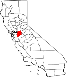 | |
| CDPs | ||
| Unincorporated communities | ||
| Ghost towns |
| |