Trams in Gotha
 Modernised Tatra KT4D tram in Gotha, 2006. | |||
| Operation | |||
|---|---|---|---|
| Locale | Gotha, Thuringia, Germany | ||
| Open | 1894 | ||
| Status | Operational | ||
| Lines | 5 | ||
| Operator(s) | Thüringerwaldbahn und Straßenbahn Gotha GmbH (TWSB) | ||
| Infrastructure | |||
| Track gauge | 1,000 mm (3 ft 3 3⁄8 in) | ||
| Propulsion system(s) | Electricity | ||
| Stock | 20 | ||
| |||
| Website | Thüringerwaldbahn und Straßenbahn Gotha GmbH (German) | ||
The Gotha tramway network is a network of tramways forming part of the public transport system in Gotha, a city in the federal state of Thuringia, Germany.
Opened in 1894, the network is currently operated by Thüringerwaldbahn und Straßenbahn Gotha GmbH (TWSB).
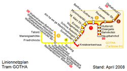
Lines
| Line | Route | Length | Travel time (min) | Stops | Headway (daytime) |
|---|---|---|---|---|---|
| Hauptbahnhof – Kreiskrankenhaus | 6.1 km | 22 min | 15 | 10 mins* | |
| Hauptbahnhof – Ostbahnhof | 3.0 km | 12 min | 8 | 20 mins | |
| Waltershäuser Straße – Ostbahnhof | 4.0 km | 14 min | 10 | (3 services/day) | |
| Thüringerwaldbahn Gotha – Waltershausen Gleisdreieck – Friedrichroda – Tabarz |
21.7 km (22.5 km incl. Krankenhaus) | 58 min | 22 | 30 mins | |
| Waltershausen Gleisdreieck – Waltershausen Bahnhof | 2.4 km | 7 min | 5 | ≈ 30 mins | |
Notes:
* The headway figure for line 1 takes into account the services on line 4.
Since the timetable change on 13 December 2009, there has been only one pair of line 4 trains each day via Krankenhaus. At other times, travellers to/from Krankenhaus must change to line 1 in Sundhausen.
The old line 3 linked the Huttenstraße with Hauptfriedhof with one intermediate stop, and was shut down on 30 June 1985. From 1 June 1985 to 1991, a SEV line 3 led from the old Busbahnhof to Hauptfriedhof. Today, this route is operated on Monday to Saturday by city bus line F and the evening line, on Monday to Friday by city bus line E, and on Sundays by city bus line B.
The branch line in Waltershausen formerly belonging to line 4 (between Waltershausen Bahnhof und Waltershausen-Gleisdreieck) has operated since August 2007 as line 6.
See also
References
- Bauer, Gerhard; Kuschinski, Norbert (1994). Die Straßenbahnen in Ostdeutschland [The Tramways in East Germany]. Band 2: Sachsen-Anhalt, Thüringen [Volume 2: Saxony-Anhalt, Thuringia]. Aachen, Germany: Schweers + Wall. ISBN 392167980X. (German)
- Schwandl, Robert (2012). Schwandl's Tram Atlas Deutschland (in German and English) (3rd ed.). Berlin: Robert Schwandl Verlag. ISBN 9783936573336.
External links
![]() Media related to Trams in Gotha at Wikimedia Commons
Media related to Trams in Gotha at Wikimedia Commons
- Gotha database / photo gallery and Gotha tram list at Urban Electric Transit – in various languages, including English.
- Gotha database / photo gallery at Phototrans – in various languages, including English.
| Baden-Württemberg |  | |
|---|---|---|
| Bavaria | ||
| Berlin | ||
| Brandenburg |
| |
| Bremen | ||
| Hesse | ||
| Lower Saxony | ||
| Mecklenburg-Vorpommern | ||
| North Rhine-Westphalia | ||
| Rhineland-Palatinate | ||
| Saarland | ||
| Saxony | ||
| Saxony-Anhalt | ||
| Thuringia | ||
| ||
Urban public transport networks and systems in Germany | ||
|---|---|---|
| S-Bahn |  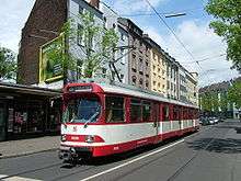  | |
| U-Bahn | ||
| Stadtbahn | ||
| Trams |
| |
| Trolleybuses | ||
| Suspension monorails | ||
| Other | ||
| ||
Coordinates: 50°57′N 10°43′E / 50.950°N 10.717°E