Trams in Würzburg
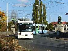 A GT-N tram crossing the Löwenbrücke, Würzburg, 2007. | ||||||||||||||||||||||||||||
| Operation | ||||||||||||||||||||||||||||
|---|---|---|---|---|---|---|---|---|---|---|---|---|---|---|---|---|---|---|---|---|---|---|---|---|---|---|---|---|
| Locale | Würzburg, Bavaria, Germany | |||||||||||||||||||||||||||
| ||||||||||||||||||||||||||||
| ||||||||||||||||||||||||||||
The Würzburg tramway network (German: Straßenbahnnetz Würzburg) is a network of tramways forming part of the public transport system in Würzburg, a city in the federal state of Bavaria, Germany.
The network presently consists of five lines,[1] with a total track length of 42 kilometres (26 mi)[3] (yielding a one-way route length of approximately 21 kilometres (13 mi)). It is currently operated by Würzburger Straßenbahn GmbH, a subsidiary of Würzburger Versorgungs- und Verkehrs-GmbH (WVV).
History
The first horse-drawn tramway opened in Würzburg in 1892.[3][4] The first electric trams went into operation in Würzburg in 1900.[3]
Beginning in the 1990s, a concerted effort was made to move Würzburg's tramlines into their own rights-of-way and convert them more to a light rail (Stadtbahn) type of operation over the traditional tram system operating in regular road traffic. Currently, most of Würzburg tramlines, outside of sections downtown and in the Sanderau district, operate as light rail in their own rights-of-way. In addition, low-floor light rail vehicles were purchased.
Lines
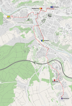
As of 2013, the network was made up of the following five lines:[1][2]
| Line | Route | Travel time | Length* |
|---|---|---|---|
| 1 | Grombühl Uni-Kliniken – Hauptbahnhof | 20 min. | 10.4 km |
| 2 | Hauptbahnhof | 14 min. | 8.0 km |
| 3 | Hauptbahnhof | 27 min. | 19.3 km |
| 4 | Sanderau – Sanderring – Stadtmitte – Wörthstraße – Zellerau | 23 min. | 12.6 km |
| 5 | Grombühl Uni-Kliniken – Hauptbahnhof | 39 min. | 26.2 km |
* The figure refers to both directions, ie a complete round trip.
Rolling Stock
The rolling stock is monodirectional (has the driver's cab only at one end) & has doors only on the right.
See also
References
Notes
- 1 2 3 "Linieninformationen - Großwabe Würzburg" [Line Information - (in) the Würzburg 'honeycomb'] (in German). Verkehrsunternehmens-Verbund Mainfranken GmbH (VVM). Retrieved 2013-10-04.
- 1 2 3 "Liniennetz der Straßenbahn in Würzburger" [Tram Line Network in Würzburg] (PDF) (in German). Verkehrsunternehmens-Verbund Mainfranken GmbH (VVM). September 2010. Retrieved 2013-10-04.
- 1 2 3 4 5 6 "Nahverkehr - Fahrgäste - Wissenswertes - Straßenbahn der WSB - Übersicht" [Suburban Traffic - Passengers - Things worth knowing - The Tram of the WSB - Overview] (in German). Würzburger Versorgungs- und Verkehrs-GmbH (WVV). Retrieved 2013-10-04.
- ↑ "Über uns - Historie - Übersicht" [About us - History - Overview] (in German). Würzburger Versorgungs- und Verkehrs-GmbH (WVV). Retrieved 2013-10-04.
Bibliography
- Hendlemeier, Wolfgang (1981). Handbuch der deutschen Straßenbahngeschichte [Handbook of German Tram History] (in German). 1. München.
- Höltge, Dieter; Kochems, Michael (2006). Straßen- und Stadtbahnen in Deutschland [Tramways and Stadtbahnen in Germany]. Band 10: Bayern [Volume 10: Bavaria]. Freiburg i. B., Germany: EK-Verlag. ISBN 388255391X. (German)
- Klebes, Günther (1980). Die Strassenbahnen Bayerns in alten Ansichten [The Trams of Bavaria in Old Postcards] (in German). Zaltbommel. ISBN 90-288-1197-4.
- Schwandl, Robert (2012). Schwandl's Tram Atlas Deutschland (in German and English) (3rd ed.). Berlin: Robert Schwandl Verlag. pp. 140–141. ISBN 9783936573336.
External links
| Wikimedia Commons has media related to Trams in Würzburg. |
- Würzburger Versorgungs- und Verkehrs-GmbH (WVV) – official site (German)
- Verkehrsunternehmens-Verbund Mainfranken GmbH (VVM) – official site (German)
- Würzburg database / photo gallery and Würzburg tram list at Urban Electric Transit – in various languages, including English.
- Würzburg database / photo gallery at Phototrans – in various languages, including English.
| Baden-Württemberg |  | |
|---|---|---|
| Bavaria | ||
| Berlin | ||
| Brandenburg |
| |
| Bremen | ||
| Hesse | ||
| Lower Saxony | ||
| Mecklenburg-Vorpommern | ||
| North Rhine-Westphalia | ||
| Rhineland-Palatinate | ||
| Saarland | ||
| Saxony | ||
| Saxony-Anhalt | ||
| Thuringia | ||
| ||
Urban public transport networks and systems in Germany | ||
|---|---|---|
| S-Bahn |  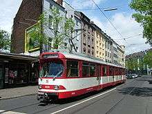  | |
| U-Bahn | ||
| Stadtbahn | ||
| Trams |
| |
| Trolleybuses | ||
| Suspension monorails | ||
| Other | ||
| ||
Coordinates: 49°47′N 09°56′E / 49.783°N 9.933°E