Transport in Cambridge
Cambridge is a university town and the administrative centre of the county of Cambridgeshire, England. It lies in East Anglia about 50 miles (80 km) north of London. Its main transport links are the M11 road to London, the A14 east-west road and the West Anglia Main Line railway line to London.
Buses
Cambridge has several bus services including routes linking five Park and Ride sites all of which operate seven days a week and are aimed at encouraging motorists to park near the city's edge.[1] Since 7 August 2011, the Cambridgeshire Guided Busway has bus services running into the centre of Cambridge.
Most buses run to and from the bus station located on Drummer Street in the heart of the city, although there are significant interchanges at the railway station and at Addenbrooke's Hospital. The principal operator is Stagecoach.
Cambridgeshire Guided Busway

Cambridgeshire Guided Busway is the world's longest guided busway and passes through Cambridge.[2] The designated route runs on normal road from Huntingdon to St Ives, then via a bus-only guided section along a former railway line south-westwards into Cambridge, where it rejoins the road at either Milton Road or Histon Road and then continues to Cambridge railway station on normal roads. From there it will again be guided to Addenbrooke's Hospital and Trumpington Park and Ride.[3] The scheme, budgeted at £116.2 million, had been scheduled to open in early 2009[4] but opening in August 2011.[5] The scheme had been heavily criticised by campaigners who believed that the route would be better served by restoring the existing railway route.[6]
Park and ride
The city is served by a seven days a week park and ride scheme. Five sites on the outskirts of the city or just outside its boundaries - at Babraham Road, Madingley Road, Milton, Newmarket Road and Trumpington - provide parking spaces for a total of over 4,500 cars.[7][8][9][10][11] Buses run from these sites into the city centre.
Roads
Because of its rapid growth in the 20th century, Cambridge has a congested road network.[12] Several major roads intersect at Cambridge. The M11 motorway from east London terminates to the north-west of the city where it joins the A14. Skirting the northern edge Cambridge, the A14 is a major freight route which connects the port of Felixstowe on the east coast with the Midlands, North Wales, the west coast and Ireland. The A14 is often congested, particularly the section between Huntingdon and Cambridge where the east–west traffic is merged with the A1 to M11 north–south traffic on a 2-lane dual carriageway.[13] Cambridge is situated on the A10, a former Roman road from north London to Ely and King's Lynn. The A428 connects the city with Bedford and St Neots, and the A1303 to Newmarket and beyond to Colchester.
Some roads around the city have been designated as forming a ring road about a mile and a half in diameter, inside which there are traffic restrictions.
There are five council car parks in the city centre. There are limited numbers of metered bays offering parking for up to 1–8 hours across the city[14]
Cycling
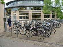
As a university town lying on fairly flat ground and with traffic congestion, Cambridge has a large number of cyclists. Many residents also prefer cycling to driving in the narrow, busy streets, giving the city the highest level of cycle use in the UK.[15] According to the 2001 census, 25% of residents travelled to work by bicycle. A few roads within the city are adapted for cycling, including separate traffic lights for cycle lanes and cycle contraflows on streets which are otherwise one-way; the city also benefits from parks which have shared use paths. There are, however, no separate cycle paths within the city centre. Despite the high levels of cycling, expenditure on cycling infrastructure is around the national average of 0.3% of the transport budget. There are a few cycle routes in the surrounding countryside and the city is now linked to the National Cycle Network. The main organisation campaigning to improve conditions for cyclists in Cambridge is the Cambridge Cycling Campaign.[16] The city was chosen as a Cycling Town by the Department for Transport in 2008, with central government funding an expansion of cycling facilities in the city and its surrounding villages.[17] There was a 5% increase in cycling from 2013 to 2014 - an increase of 88% since 2004.[18]
Bike theft in the city is a problem, with over 3000 bicycles reported stolen between April 2005 and March 2006. The actual number is believed to be higher as many thefts are not reported to the police.[19]
Rail
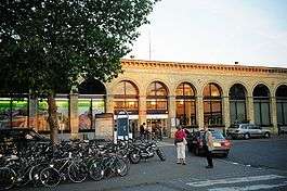
Cambridge railway station was built in 1845 with a platform designed to take two full-length trains, the third longest in the country. Cambridge has direct rail links to London with termini at London King's Cross (on the Hitchin-Cambridge Line and the East Coast Main Line) and Liverpool Street (on the West Anglia Main Line). There is a direct shuttle service to King's Cross every half hour during off peak hours.[20] Peak hour trains to King's Cross have additional stops. Future developments for the Cambridge to London line include the provision of 125 miles per hour (201 km/h) high speed trains.[21] The line is currently graded for 100 miles per hour (161 km/h). The line is all welded rail, but because of the flat geography there are many level crossings, and they make it harder to run at higher speeds.
Cambridge is linked by rail to King's Lynn and Ely (via the Fen Line), Norwich (via the Breckland Line), Leicester, Birmingham New Street, Ipswich and London Stansted Airport. The important UK rail hub of Peterborough is also less than an hour from Cambridge, which provides direct connections to Leeds, Newcastle and Edinburgh Waverley. Cambridge railway station is run by Abellio Greater Anglia.

The railway service connecting Cambridge and Oxford, known as the Varsity Line, ceased in 1968. The East West Rail Link proposal now plans to reinstate a direct rail route to Oxford.
Air
The nearest passenger services are from London Stansted Airport at 28 miles (45 km) and London Luton Airport at 32 miles (51 km), Birmingham Airport, London Gatwick Airport and London Heathrow Airport all being about 90 minutes' travel, and the smaller London City Airport approximately 75 minutes' travel.
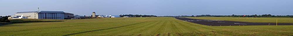
The city's own airport is Cambridge Airport (formerly Marshall Airport Cambridge UK and originally Teversham Aerodrome) and is owned by Marshall Aerospace. There are no scheduled passenger services, though the runway can accommodate an unladen Boeing 747 or MD-11 and ScotAirways used to make scheduled flights to Amsterdam Schiphol Airport. The airport is used mainly by business, leisure and training flights, and to fly in aircraft for maintenance.[22][23][24] In 2004 a charter service to Jersey was operated and flights to other European destinations such as Gothenburg were operated on either a scheduled or charter basis. At the end of January 2016 all scheduled and charter flights from the airport were halted due to a lack of passenger numbers.[25]
A dealer in fibreglass-moulded light monoplanes is also based at the airport. Controversially it has been mooted to remove Marshalls to a site away from the city, and develop the land with housing.[26] Sir Arthur Marshall, the founder of the company, died in 2007.
Current Developments
Cambridge Cycling Town
In 2008 Cambridge was awarded the status of "Cycling Town", and granted £3.6 million to spend on cycling improvements.[27] Cambridgeshire County Council currently plans to use the money to construct six new cycle paths in the city and its surrounding area:
- Cottenham to Histon
- Histon to Cambridge
- Harston to Cambridge
- Babraham Road Park & Ride to Wandlebury
- Fen Ditton to Horningsea
- Milton to Impington
Cambridge Gateway
In order to promote safety and improve access to Cambridge railway station, the County Council is redeveloping the area surrounding it. Work is set to commence by the end of 2010 and continue for about a year,[28][29] at an estimated cost of £3.1 million. The redevelopment of the Cambridge Station area has been given the green light and has been awarded £1.5 million of central government money to help pay for the scheme. The Hills Road Bridge safety scheme is still included in the project.
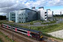
Cambridge North railway station
A second railway station for the city, in the Chesterton district, has been approved by central government.[30] The station will serve routes to Norwich, King's Lynn, Birmingham New Street, London Liverpool Street and London King's Cross, and will also be linked with the Guided Busway.[31] The planned opening date is May 2017.[32]
Proposed developments
|
Project Cambridge developments. | |
| Location | Cambridge |
|---|---|
| Proposer | Cambridgeshire County Council |
| Status | proposed |
| Type | multi-modal |
| Cost estimate | £25 million |

Several developments to the transport system in Cambridge have been proposed, mostly by Cambridgeshire County Council.
In 2009 the County Council revealed its plans to spend £25 million on renovating the area from Regent Street to the Cherry Hinton Road Junction, entitled Project Cambridge. The scheme is composed of many smaller projects with common themes of making junctions easier for pedestrians to cross, promoting cycle use and reducing traffic.[33] The scheme, criticised for not having had consultation with councillors or the public,[34] is to be funded through tax increment financing where the money would initially be borrowed and would be repaid over 25 years from increases in business tax revenue. The scheme was due to be discussed by councilors in October 2009.[35]
A safety improvement scheme has been developed for parts of Mill Road, due to the very high accident rate in the area.[36] The proposal includes the removal of the road's central line and speed humps added along its length as well as reducing the speed limit along the road to 20 mph (32 km/h).[37]
See also
References
- ↑ http://www.cambridgeshire.gov.uk/transport/around/parkandride Cambridge park-and-ride
- ↑ Secretary Of State Celebrates Start Of Works On Guided Busway
- ↑ Cambridgeshire Guided Busway
- ↑ Guided Busway leaflet
- ↑ Extance, Rachel. "Guided bus launch delayed until end of summer". Cambridge Evening News. Retrieved 2009-02-25.
- ↑ "Campaigners still hope to stop the guided bus". Cambridge Evening News. 2006-08-25. Retrieved 2008-10-29.
- ↑ "Babraham Road site facilities".
- ↑ "Madingley Road Park and Ride".
- ↑ "Milton".
- ↑ "Newmarket Road Park and Ride".
- ↑ "Trumpington Road Park and Ride".
- ↑ http://www.cambridgefutures.org/futures2/report1.htm
- ↑ http://www.highways.gov.uk/roads/projects/4221.aspx
- ↑ "Paring Meters Map". Cambridge City Council. Retrieved 2009-12-13.
- ↑ http://www.statistics.gov.uk/CCI/SearchRes.asp?term=KS15&btnSubmit=Search UK Census 2001
- ↑ Cambridge Cycling Campaign
- ↑ "Cycling City, Cycling Towns". Cycling England. Retrieved 2009-10-13.
- ↑ "Massive wave of cycling as tide of motorists in Cambridge held back". Cambridge News. 16 November 2015. Retrieved 16 November 2015.
- ↑ "Raids 'shockwave' for bicycle theft gangs". Cambridge Evening News. 27 July 2006.
- ↑ "First Capital Connect Train Timetables". Retrieved 10 February 2009.
- ↑ "125mph trains to cut Cambridge times". Retrieved 2009-02-12.
- ↑ "Cambridge Airport"
- ↑ "Cambridge Flying Club"
- ↑ "Cambridge Aero Club"
- ↑ Cambridge Airport axes charter and scheduled passenger flights, Cambridge News, 2015-12-02. Retrieved 2016-02-02.
- ↑ "At Cambridge East, centred on the airport, there are plans for 12,000 homes - if and when Marshalls relocate." Cambridge Evening News, "Shaping the Future of a Growing City", 26 June 2007 retrieved 9 August 2008
- ↑ "Cambridge Announced as National Cycling Town". Retrieved 2009-10-14.
- ↑ "Cambridge Gateway and Hills Road Safety Scheme". Retrieved 2009-08-13.
- ↑ Local Transport Today, Issue 557, page 0
- ↑ "Cambridge's new railway station 'to open in 2015'". Cambridge News. 21 February 2012. Retrieved 27 February 2012.
- ↑ "On track to move Science Park Station from concept to reality". Cambridgshire County Council. 21 February 2012. Retrieved 27 February 2012.
- ↑ "New Cambridge North station won't open until May 2017, Network Rail confirms". Cambridge News. 21 January 2016. Retrieved 21 January 2016.
- ↑ "Project Cambridge" (PDF). Cambridgeshire County Council. September 2009. Retrieved 2009-10-21.
- ↑ "New Scheme to Improve Hills Road". 2009-10-12. Retrieved 2009-10-21.
- ↑ "£25m city scheme for cyclists and pedestrians". Cambridge Evening News. Retrieved 2010-01-12.
- ↑ "Mill Road Accident Remedial Scheme". Retrieved 2009-10-14.
- ↑ "Consultation Drawing" (PDF). Cambridgeshire County Council. Retrieved 2009-10-14.