Transport in Tanzania
Transport in Tanzania includes road, rail, air and water networks. The road network is 86,472 kilometres (53,731 mi) long, of which 12,786 kilometres (7,945 mi) is classified as trunk road and 21,105 kilometres (13,114 mi) as regional road.[1] The rail network consists of 3,682 kilometres (2,288 mi) of track. Commuter rail service is in Dar es Salaam only. There are 28 airports, with Julius Nyerere International being the largest and the busiest. Ferries connect Mainland Tanzania with the islands of Zanzibar. Several other ferries are active on the countries' rivers and lakes.
Roads
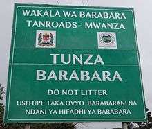
The Tanzania National Roads Agency (TANROADS) - an Executive Agency under the Ministry of Works, Transport and Communications - came into operation in July 2000 and is the agency responsible for the maintenance and development of the trunk and regional road network in Mainland Tanzania. The total classified road network in Mainland Tanzania was estimated to be 86,472 kilometres (53,731 mi) based on the Road Act 2007. The Ministry of Works through TANROADS is managing the national road network of about 33,891 kilometres (21,059 mi), comprising 12,786 kilometres (7,945 mi) of trunk road and 21,105 kilometres (13,114 mi) of regional road. The remaining network of about 53,460 kilometres (33,220 mi) of urban, district and feeder roads is under the responsibility of the Prime Minister’s Office Regional Administration and Local Government (PMO-RALG).[1]
In 2007 there were 91,049 kilometres (56,575 mi) of roads, of which including 6,578 kilometres (4,087 mi) was paved. The road network ranked 51st worldwide by length.[2]
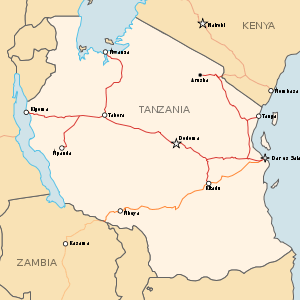
Trunk roads

- Dar es Salaam and Dodoma (451 kilometres (280 mi) entirely paved):[3] The A-7 road links Dar es Salaam and Morogoro. The B-129 road then connects Morogoro with Dodoma.
- Dar es Salaam and Iringa (492 kilometres (306 mi)[3] entirely paved): The A-7 road links these cities.
- Dar es Salaam and Tanga (354 kilometres (220 mi)[3] entirely paved): The A-7 road links Dar es Salaam and Chalinze. The A-14 road then connects Chalinze with Tanga.
- Dar es Salaam and Mtwara (556 kilometres (345 mi)[3] mostly paved): The B-2 road links these cities. It is paved from Mtwara to Lindi and Somanga.[4] An unpaved road links Somanga with Ndundu to the north. The paving of this road is ongoing but has experienced many long delays.[5] The remainder of the road to Dar es Salaam is paved. The long Mkapa Bridge is on this stretch of road, spanning the Rufiji River.
- Tanga and Arusha (435 kilometres (270 mi)[3] entirely paved): The A-14 road connects Tanga and Segera. From there, the B-2 road connects Segera with the road's terminus at the Himo Junction. The A-23 road then leads west to Moshi and Arusha.
- Dodoma and Mwanza on Lake Victoria (701 kilometres (436 mi)[3] (entirely paved): The B-129 road leads west to Manyoni, followed by the B-141 road north to Singida. From there, the B-3 road leads mostly west to Nzega. The final stretch is on the B-6 road through Shinyanga to Mwanza.[6][7][8]
- Dar es Salaam and the border with Rwanda at Rusomo Falls (1,281 kilometres (796 mi) (entirely paved): From Nzega in the Tabora Region, the B-3 road leads to the Rwandan border (380 km (240 mi)).
- Kigoma and the border with Burundi at Manyovu: The road is entirely paved.
- Mwanza and Musoma (218 kilometres (135 mi)[3] entirely paved): The B-6 road connects these cities and then proceeds north to the Kenyan border.
- Arusha and Namanga on the Kenyan border (106 kilometres (66 mi): The A-104 road is entirely paved.
- Iringa and Mbeya (330 kilometres (210 mi)[3] entirely paved): The A-104 road links these cities, with its terminus in Tunduma on the Zambian border.
Most of the trunk roads in Tanzania are marked by numbers following the two-tier number system with prefixes A- and B-, as is practiced in the rest of East Africa.[9] Following is the list of Tanzanian trunk roads.[10]
| Road No. | Length | Span | Via | Status | Remarks |
|---|---|---|---|---|---|
| A7 | 492 km | Dar es Salaam - Iringa | Chalinze - Morogoro - Mikumi | Paved | |
| A14 | 315 km | Chalinze - Horohoro | Segera - Tanga | Paved | Continues in Kenya up to Mombasa |
| A19 | 620 km | Masasi - Mbamba Bay | Tunduru - Songea - Mbinga | Paved/Unpaved | Paved: Masasi - Ngomano Road (56 km) and Namtumbo - Mbinga (168 km) |
| A23 | 117 km | Arusha - Holili | Moshi | Paved | Continues in Kenya up to Voi |
| A104 | 1,218 km | Tunduma- Namanga | Mbeya - Iringa - Dodoma - Kondoa - Arusha | Paved/Unpaved | Part of Cape Town - Cairo Highway, Unpaved: Dodoma - Babati (257 km) |
| B1 | 263 km | Segera - Himo | Paved | Connects A14 with A23 | |
| B2 | 561 km | Dar es Salaam - Mtwara | Kilwa - Lindi | Paved | Paved 30 km road to Kilwa Masoko from Nangurukuru |
| B3 | 625 km | Singida - Rusumo Falls | Nzega - Isaka - Kahama | Paved | Runs with B6 Nzega - Tinde (42 km), Continues as RN3 in Rwanda up to Kigali |
| B4 | 293 km | Makambako - Songea | Njombe | Paved | |
| B5 | 120 km | Mingoyo - Masasi | Paved | Connects B2 to A19 | |
| B6 | 1,071 km | Makogolosi - Sirari | Rungwa - Tabora - Shinyanga - Mwanza | Paved/Unpaved | Paved: Nzega - Sirari (524 km), Runs with B3 Nzega - Tinde (42 km) |
| B8 | 1,128 km | Kasesha - Mutukula | Sumbawanga - Mpanda - Kasulu - Biharamulo - Bukoba | Paved/Unpaved | Paved: Lusahunga (B3) - Mutukula (287 km) |
| B129 | 388 km | Morogoro - Manyoni | Dodoma | Paved | |
| B141 | 308 km | Rungwa - SIngida | Itigi - Manyoni | Paved/Unpaved | Paved: Itigi - Singida (160 km) |
| B143 | 151 km | Singida - Babati | Paved | ||
| B144 | 390 km | Makuyuni - Kukirango | Karatu - Ngorongoro - Serengeti National Park | Paved/Unpaved | Paved: Makuyuni - Ngorongoro (79 km), rest can't be paved because it's a National Park |
| B163 | 230 km | Usagara - Biharamulo | Sengerema - Geita | Paved/Unpaved | Unpaved: Bwanga - Biharamulo (68 km), a paved road runs via Chato to go to Bukoba |
| B182 | 171 km | Nyakasanza - Kyaka | Kimisi - Burigi Game Reserve - Omurushaka | Paved/Unpaved | Paved: Omurushaka - Kyaka (57 km), connects B3 to B8 |
| B182 W | 111 km | Omurushaka - Murongo | Upaved | Branches from B182 and runs up to Murongo border crossing with Uganda | |
| 173 km | Bulahu - Lamadai | Bariadi | Paved/Unpaved | Paved: Bariadi - Lamadai (72 km), marked as trunk road by TANROADS but no number | |
| 59 km | Nyakasanza - Kobero | Ngara - Kabanga | Paved | Branches from B3 up to Kobero border crossing with Burundi, continues as RN6 there |
Regional roads
- Mtwara Region: Paved roads link Mtwara and Masasi and from there almost to Nangoma. An unpaved road then leads to Mtambaswala and the modern Unity Bridge on the Mozambique border.[11] The African Development Bank in April 2012 approved a loan to Tanzania to pave this road,[12] followed in April 2013 with an additional loan of 7.659 billion yen (US $77.9 million) from Japan.[13]
- Western regions are the most poorly served, with no paved highways except locally in Kigoma and Ujiji. Only one dirt road runs down the western side of the country, it is just a track between Kasulu and Sumbawanga and prone to flooding south of Mpanda. Between Tunduma in the south-west and Nyakanyazi junction near Kibondo in the north-west, a distance of nearly 1000 km, there are no highways in the centre of the country.
International highways

The Cairo-Cape Town Highway, Highway 4 in the Trans-African Highway network, runs between the northern town of Namanga on the Kenyan border and the Zambian border town of Tunduma in the southwest, via Arusha, Dodoma, Iringa, and Mbeya. The section between the entrance to Tarangire National Park and Iringa is unpaved and can be difficult when raining, especially north of Kondoa. A longer eastern route from Arusha to Iringa via Moshi and Morogoro is paved. This route is 921 kilometres (572 mi) versus 689 kilometres (428 mi) for the Arusha-Dodoma-Iringa route.[3]
In the southwest, from Iringa to Tunduma, the Cairo-Cape Town Highway follows the Tanzam Highway linking Zambia and Dar es Salaam.
Rail transport
In 2008 Tanzania had 3,689 km (2,292 mi) of rail, ranking it 46th in the world by length It includes 2,720 km (1,690 mi) of 1,000 mm (3 ft 3 3⁄8 in) Metre gauge and 969 km (602 mi) of 1,067 mm (3 ft 6 in) gauge track. On 31 March 2015 the Tanzanian government announced it would use $14.2 billion of commercial loans to build new rail infrastructure across the country before 2021 and make the country a regional transport hub.[14]
Tanzania Railways
Proposals have been made for a railway to link Mtwara to iron ore deposits in the west, possibly connecting to Mbeya.
The central line between Kigoma and Dar es Salaam carries international freight and passengers in transit from Burundi, the Democratic Republic of the Congo, and Rwanda to the Indian Ocean, and the branch from Tabora to Mwanza carries freight and passengers between Uganda and the Indian Ocean.
Isaka Dry Port is a small town and station on the Mwanza Line at its intersection with the paved highway to Kigali. It has been developed into a so-called 'dry port' for trans-shipping Burundian and Rwandan road freight onto freight trains for the seaport of Dar es Salaam. There are proposals to build a railway from Isaka to Rwanda/Burundi.[15]
TAZARA Railway
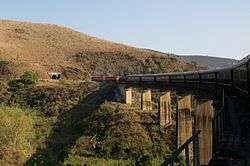
The Tanzania-Zambia Railway Authority (TAZARA), formerly also called TanZam Railway operates 1,860 km (1,156 mi) of 1,067 mm (3 ft 6 in) narrow gauge track (matching Zambian/Southern African networks) between Dar es Salaam and Kapiri Mposhi in Zambia, of which 969 km or 602 mi is in Tanzania and 891 km or 554 mi in Zambia). It is not a part of Tanzania Railways Corporation, and because of the difference in gauge there is no rail connection between the networks.[16] There is a container trans-shipment yard to transfer freight containers between TAZARA and Tanzania Railways Corporation at Kidatu near Morogoro. This allows containers to be shipped from as far as Uganda and Kenya via the Lake Victoria train ferries and the Kidatu yard to the Southern African rail network via Zambia.
- Dar es Salaam - ocean port - 8 km from TRC line [17]
- Kidatu - break of gauge connection with Tanzania Railways Corporation, with a container trans-shipment facility
- Mbeya
- Tunduma - Zambian border
Urban rail
Air transport

Airports
Air travel is regulated by the Tanzania Civil Aviation Authority. The Tanzania Airports Authority operates 25 airports out of the 58 aerodromes on the Tanzania mainland. Kilimanjaro International is managed by the state-owned Kilimanjaro Airport Development Company, whilst airports in the semi-autonomous Zanzibar Archipelago are under the jurisdiction of the Zanzibar Airports Authority. Fifteen airports offer the airport of entry service.
Air services, both chartered and scheduled, are provided by local airlines such as the flag carrier Air Tanzania, Precision Air and Coastal Aviation. Prior to the launch of Fastjet, a low-cost carrier, air travel was and still is unaffordable for the vast majority due to high fares. The lowest fare offered by Fastjet for a single journey is US$20 (excluding tax) and its domestic route network is limited to only five destinations as the Airbus A319 requires 2,164 metres (7,100 ft) of runway for takeoff.
The government is cognizant of the importance of air travel to the economy and has therefore rehabilitated airports at strategic locations such as Kigoma to capture the market from neighboring countries. It intends to construct Kajunguti International Airport in the northwest to serve the African Great Lakes region. Other major airports under planning and consideration are Msalato International and Serengeti International, which will serve the capital Dodoma and the Serengeti National Park respectively.
Airstrips

There are a considerable number of both public and private airstrips. Tanzania Airports Authority manages 32 airstrips, such as Morogoro and Singida.
The Tanzania National Parks Authority operates 26 airstrips in national parks. Seronera Airstrip is the busiest in the country. Sixty-one airstrips are operated by the Ministry of Natural Resources and Tourism.
Private organisations own 93 aerodromes such as the Tanzania Petroleum Development Corporation operating Songo Songo Airstrip.[18]
Water transport
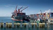
Ports and harbours
There is an abundance of coastal and lake waterways. In the central areas there are no navigable lakes or rivers. There is a strong maritime tradition going back centuries. Zanzibar was once the chief port on the East African, Indian Ocean coast. Its hinterland reached into Central Africa as far as the middle Congo River. Swahili traders used dhows to conduct trade though many ports along the coast. This tradition continues today with motorized craft. In 2010, the government announced plans to develop a new port at Mbegani, near Bagamoyo as a deepwater harbour with a two-berth container terminal.[19]
Ferries
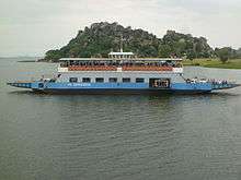
- Lake Victoria
For about 80 years, the Lake Victoria ferries have carried rail wagons and vehicles from Uganda to Tanzania. The ferries are jointly run by the railway companies of Tanzania and Uganda and are the main means of transport between Tanzania and Uganda as well as between northern Tanzania and southwestern Kenya. Other ferry services link the Zanzibar archipelago and Tanzanian ports.
- Lake Tanganyika
Once a rival to Lake Victoria as a waterway, the Lake Tanganyika ferries are no longer as busy and train ferries no longer operate. Trade has suffered from wars in the Democratic Republic of the Congo. Small ferries link communities along the Tanzanian shore (some with no road access), and commercial traffic runs between Kigoma and Bujumbura, Burundi and Mpulungu, Zambia, including the MV Liemba.
- Lake Nyasa
Communities along the northeast shore (some without road access) are linked by ferry, and Malawian steamer and boat services have run the length of the lake for about 120 years.
Merchant marine
In 2008 the merchant fleet consisted of nine Tanzanian-flagged vessels and one registered in Honduras. The small number of ships may be attributed to the few exports, the relative insufficiency of its coast guard and naval forces, and the single major port in Dar es Salaam. The nine domestically-flagged ships are one cargo ship, four passenger/cargo ships, and four oil tankers.
Other modes
Pipeline transport
In 2008 there were 253 km (157 mi) of gas pipeline, 888 km (552 mi) of oil pipeline, and an 8 km (5.0 mi) pipeline for refined petroleum products. The privately owned Tazama Pipeline accounts for a large portion of the crude oil transportation capability. It currently handles 600,000 tons of crude oil per year, but was designed to handle 1.1 million tons.
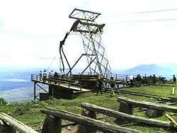
Skyline logging
A cable logging system exists in Lushoto District, whereby logs are transported from the Usambara Mountains downhill.
See also
- Ministry of Transport (Tanzania)
- Economy of Tanzania
- Usambara Railway
- East African Railway Master Plan
- Lake Victoria ferries
References
- 1 2 Tanroads http://tanroads.go.tz/. Retrieved 27 February 2016. Missing or empty
|title=(help) - ↑ "The World Factbook: Tanzania", United States Central Intelligence Agency, 10 July 2013
- 1 2 3 4 5 6 7 8 9 Road Distance Chart - June 2012.pdf Tanzania Road Distance Chart, TANROADS, June 2012
- ↑ Lindi Roads Network, TANROADS
- ↑ "Tanzania: Ndundu-Somanga Road Project Delay Saga Explained", Daily News, reprinted at allAfrica.com, 17 May 2013
- ↑ Dodoma Roads Network, TANROADS
- ↑ Singida Roads Network, TANROADS
- ↑ Shinyanga Roads Network, TANROADS
- ↑ "East African Community Infrastructure". Retrieved 5 June 2016.
- ↑ "TANROADS" (PDF). Retrieved 5 June 2016.
- ↑ Mtwara Roads Network, TANROADS
- ↑ "AfDB Approves USD 251 Million Funding for Roads in Tanzania and Sierra Leone", African Development Bank Group, 5 April 2012
- ↑ "Exchange of notes related for 'The Road Sector Support Project II'", Embassy of Japan in Tanzania, 8 April 2013
- ↑ African Markets - Factors to watch on March 31, Reuters, http://www.reuters.com/article/2015/03/31/africa-factors-idUSL6N0WX0EG20150331
- ↑ Railways Africa - STANDARD GAUGE FOR RWANDA
- ↑ TAZARA
- ↑ Railways in Tanzania
- ↑ "List of Aerodromes in Tanzania" (PDF). Tanzania Civil Aviation Authority. Retrieved 8 December 2013.
- ↑ "Green light for new Tanzanian port". November 2010. Retrieved 30 July 2013.
