Transportation in Cincinnati
Cincinnati has several modes of transportation including sidewalks, roads, public transit, bicycle paths and regional and international airports. Most trips are made by car, with transit and bicycles having a relatively low share of total trips; in a region of just over 2 million people, less than 80,000 trips[1] are made with transit on an average day. The city is sliced by three major interstate highways, I-71, I-74 and I-75, and circled by a beltway several miles out from the city limits. The region is served by two separate transit systems, one on each side of the river. SORTA, on the Ohio side is about 6 times larger than TANK on the Kentucky side.[2] The transit system is largely radial with almost all lines terminating in or departing from Downtown Cincinnati. The city's hills preclude the regular street grid common to many cities built up in the 19th century, and outside of the downtown basin, regular street grids are rare except for in patches of flat land where they're small and oriented according to topography.
Bicycles

Cincinnati Red Bike, a public bicycle sharing system, opened in the fall of 2014. The University of Cincinnati has operated a small bike-share program for several years.
Public transportation
Buses
Cincinnati is served by buses run by the Southwest Ohio Regional Transit Authority (SORTA), the Transit Authority of Northern Kentucky (TANK) and the Clermont Transportation Connection.
Almost all transit lines, including those of TANK are centered on Downtown Cincinnati. This has led many people to criticize the system for being overly radial and reliant on transfers in Downtown. Several lines in Ohio, generally those ending in '1'(31, 51, 41) don't go downtown at all but provide a link between the radial arms created by the other lines.
SORTA is significantly larger than TANK, operating more lines, at higher frequencies, and carrying about six times as many passengers on an average day.
Most of SORTA's funding comes from the City of Cincinnati, and so the most intensive transit service is confined to the city boundaries. Outside of the city is considered Zone 2, and a higher fare is charged. The Clermont Transportation Connection and Warren County Transit partially fund SORTA routes that extend into Clermont County and Warren County, respectively.[3][4] SORTA's paratransit services are partially subsidized by Hamilton County.[5] TANK is funded by Campbell and Kenton counties.
SORTA and TANK primarily operate 40 foot diesel buses, though some lines are served by longer articulated or hybrid engine buses. Paratransit services generally make use of minibuses.
Streetcar
A single streetcar line, the Cincinnati Bell Connector, runs between The Banks, Downtown, and Findlay Market in Over-the-Rhine in a 3.6-mile (5.8 km) loop. It opened in 2016. Future extensions have been proposed to the Uptown area, home to the University of Cincinnati, the regional hospitals, and the Cincinnati Zoo; and to Northern Kentucky.
Public steps
The Steps of Cincinnati are a historic mode of transportation in the hilly city. In addition to practical use linking hillside neighborhoods, the approximately 400 stairways are often used for exercise.[6]
Intercity transportation
Amtrak's Cardinal train travels to Chicago and Indianapolis to the northwest and to Washington, D.C., Philadelphia and New York City to the east. It goes in each direction three times each week and arrives in Cincinnati between 1 and 3:30am. Its ticket office and station are at Cincinnati Union Terminal.
Greyhound operates a 24-hour bus terminal in Downtown Cincinnati with trips to all major nearby cities and connections to the rest of the country. Regional carriers GO Bus and Barron's Bus also serve the terminal.[7][8] For the last couple of years, Megabus has also operated several trips a week between Cincinnati and a few major cities in the midwest. Chinatown bus lines connect Cincinnati with New York City.[9]
Abandoned subway
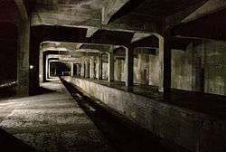
Cincinnati has an incomplete subway system. Construction stopped in 1924 when unexpected post-World War I inflation doubled the cost of construction[10] and the funds originally set aside weren't enough to complete the project. There have been several attempts in recent decades by the SORTA to use the subway tunnels for a light rail system, but ballot initiatives to generate funds for such projects have so far all failed. The most recent attempt was the 2002 MetroMoves plan which would have generated $2,700,000,000 for a comprehensive transit plan, but it failed by a 2 to 1 margin.[11] Today the subway is used as a conduit for fiber optic and water lines. It's sealed off from the public, but is occasionally home to urban explorers and the homeless.
Bridges
The city has a river ferry and many bridges. The Anderson Ferry has been in continuous operation since 1817.[12] Cincinnati's major bridges include:
- The Newport Southbank Bridge (a.k.a. the Purple People Bridge because of its status as a pedestrian-only bridge as well as its color)
- The John A. Roebling Suspension Bridge Opened in 1866, this bridge was the prototype for the Brooklyn Bridge, also designed by Roebling.
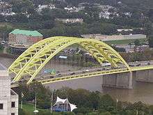
- The Daniel Carter Beard Bridge (a.k.a. the Big Mac bridge for its yellow arches, reminiscent of the McDonald's logo) carries I-471 and connects Cincinnati with Newport, Kentucky
- The Brent Spence Bridge A double-decker truss bridge carrying I-71/75 connecting Cincinnati with Covington, Kentucky
- The Clay Wade Bailey Bridge
- The Taylor-Southgate Bridge
- The Combs-Hehl Bridge a twin-span truss, part of the I-275 loop and commonly called "The 275 Bridge", it travels through Fort Thomas, Kentucky and connects to the neighborhood of California, the easternmost neighborhood in the city limits.
Airports
Cincinnati/Northern Kentucky International Airport (IATA: CVG) is the major international airport serving the metropolitan area and is located across the river in Hebron, Kentucky. CVG stands for Covington, the nearest and largest city by the airport when it was built. Although CVG serves Cincinnati, many people do not know it is actually located in Kentucky. The airport is a hub for passenger airline Delta Air Lines and midwestern base for Allegiant Air. The airport also serves as a global cargo super-hub for DHL Express, and is the 40th busiest airport in the world with cargo operations included. The city has three other airports; Lunken Airport, a municipal airfield used for smaller business jets and private planes; the Butler County Regional Airport, located between Fairfield and Hamilton, which ranks just behind Lunken in business jets and has the largest private aircraft capacity of the Cincinnati area; Cincinnati West Airport, a smaller airport located in Harrison, Ohio.
CVG Airport, along with the two other regional international airports, Dayton International Airport 78 miles (130 km) north, and Port Columbus International Airport 128 miles (210 km) northeast, form an important regional transportation network. Combined, they anchor the corners of a triangular region that serves about 50% of the population of Ohio and about 10% of Kentucky. The region encompasses over 6,000 square miles (16,000 km2) with about 50% available for development.
Highways
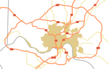
The city has an outer-belt, Interstate 275 (which is the longest loop highway in the country),[13] and a spur to Kentucky, Interstate 471. It is also served by numerous U.S. highways: US 22, US 25, US 27, US 42, US 50, US 52, and US 127.
Commerce
According to Forbes Magazine, Cincinnatians spend 20% of their income on transit, which makes the city the sixth most expensive city for commuting in the United States.[14] As of 2003, the port of Cincinnati is ranked 5th by trip ton-miles for an inland port.[15]
Several freight railroads service Cincinnati, the largest being CSX Transportation which operates a railroad yard west of Interstate 75. Other railroads include Norfolk Southern, which operates a large intermodal yard in the west end neighborhood of Queensgate and the Indiana & Ohio Railroad which operates several small predecessor yards throughout the city.
See also
References
- ↑ "Transit Ridership in Selected Urbanized Areas - US Census Bureau" (PDF).
- ↑ Wessel, Nate. "Long-term Transit Trends". Cincinnati Transit Blog. Retrieved 3 November 2013.
- ↑ "CTC Home". Clermont Transportation Connection. Retrieved 2016-09-14.
- ↑ Budd, Lawrence (June 7, 2016). "Warren County to provide loop bus service in Lebanon". Dayton Daily News. Cox Media Group Ohio. Retrieved September 19, 2016.
In 2013, the county reached an agreement with the Southwest Ohio Regional Transit Authority (SORTA) to split federal funds, rather than shift to a fixed-route system. SORTA provides transit service in Mason.
- ↑ Osborne, Kevin (October 23, 2007). "Turning Back the Bus". Cincinnati CityBeat. Retrieved September 19, 2016.
Hamilton County provides some money [to SORTA], mostly to subsidize service for disabled riders, with the remainder of the budget coming from state and federal grants.
- ↑ http://www.cincinnati-oh.gov/dote/dote-programs/hillside-steps/
- ↑ Cincinnati-Athens Stop Locations
- ↑ Bus Stop Locations
- ↑ Chinatown buses offer direct overnight travel from Cincinnati to New York City
- ↑ Pilcher, James (July 29, 2002). "Abandoned subway could save light rail plan". The Cincinnati Enquirer. Retrieved 2008-07-05.
- ↑ Pilcher, James (November 6, 2002). "Metro plan hits wall of resistance". The Cincinnati Enquirer. Retrieved 2008-07-05.
- ↑ Anderson Ferry - Cincinnati Ohio, Northern Kentucky
- ↑ Smith, Steve; et al. (2007). "Around Town: How to Decode Cincinnati's Many Motorways". Cincinnati USA City Guide. Cincinnati Magazine. p. 79. Retrieved 2013-05-06.
- ↑ Forbes Magazine. America's Most Expensive Commutes: 6. Cincinnati, Ohio. Accessed on 4/12/2009.
- ↑ "Top 20 Inland U.S. Ports for 2003" (PDF). Waterborne Commerce Statistics Center. The U.S. Army Engineer Institute for Water Resources. 2003. p. 1. Retrieved 2008-11-21.