Transportation in Seattle
As with many cities in western North America, transportation in Seattle is largely by automobile, although Seattle is just old enough that its layout reflects the age when railways and trolleys dominated. These older modes of transportation made for a relatively well-defined downtown and strong neighborhoods at the end of several former streetcar lines, most of them now bus lines.
Because of the isthmus-like geography of Seattle and the concentration of jobs within the city, much of the transportation movement in the Seattle metropolitan area is through the city proper. North-south transportation is highly dependent on Interstate 5 corridor, which connects the Puget Sound area with southwest Washington cities, the Portland metropolitan area, and cities to the north such as Bellingham. I-5 continues as British Columbia Highway 99 at the US-Canada border's Peace Arch crossing, between Blaine and Surrey. State Route 99 is also a major arterial in the western half of the city and includes the Alaskan Way Viaduct along the Seattle waterfront. Because of seismic instability, the Alaskan Way Viaduct replacement tunnel will succeed the elevated viaduct in 2025. Transportation to and from the east is via State Route 520's Evergreen Point Floating Bridge and Interstate 90's Lacey V. Murrow Memorial Bridge and Third Lake Washington Bridge, all over Lake Washington. Those bridges are the first, second, and fifth longest floating bridges in the world, respectively. State Route 522 connects Seattle to its northeastern suburbs.
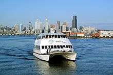
Unlike most North American cities, water transportation remains important. Washington State Ferries, the largest ferry system in the United States and the third largest in the world, operates a passenger-only ferry from Colman Dock in Downtown to Vashon Island, car ferries from Colman Dock to Bainbridge Island and to Bremerton, and a car ferry from West Seattle to Vashon Island to Southworth. Seattle was once home to the Kalakala, a streamlined art deco-style ferry that plied the waters from the 1930s to the 1960s.
Seattle contains most of Boeing Field, officially called King County International Airport, but most of the city's airline passengers use Seattle-Tacoma International Airport in the city of SeaTac. Seattle is also served by three Amtrak routes at King Street Station: the Cascades, the Coast Starlight, and the Empire Builder.
History

Even though Seattle is old enough that railways and streetcars once dominated its transportation system, the city is now largely dominated by automobiles, but has recently started rebuilding streetcar lines and light rail routes. Seattle is also serviced by an extensive network of bus routes and two commuter rail routes connecting it to many of its suburbs.
Organized land transportation in Seattle dates back at least to 1871; by that date a wagon traveled twice daily from what is now First Avenue (near Elliott Bay) to Lake Washington; the fare was 50 cents, no small sum for that era. In 1880 a two-horse carriage carried passengers and freight from roughly today's Pioneer Square to Belltown every two hours at a fare of 12.5 cents in an open coach or 15 cents in a covered coach. This was shortly followed by similar services connecting out to Lake Union and to Madison Park on Lake Washington.[1]
Water transport was important even within what are now city limits. A steamer connected South Lake Union to Latona (between today's Lower Wallingford and the University District and another steamer crossed Green Lake.
The first street railway came in 1884, with horse-drawn cars plying 3.5 miles (5.6 km) of track up today's Second Avenue to Pine Street, then up First Avenue to Battery Street.[1][2] Yesler Way and Jackson Street got their cable cars (from Pioneer Square to Lake Washington) in 1888, allowing public transportation on routes over hills too steep for horses. Electric streetcars appeared in 1889, making Seattle one of the first cities in the United States to adopt this innovation.[3][4]
The Great Seattle Fire did not slow this progress at all: by 1890, there were lines along the waterfront from South Seattle (today's South Park) to Lower Queen Anne and from the center of town to Capitol Hill, Madison Park, and Madrona.[3] These were instrumental in the creation of a relatively well-defined downtown and strong neighborhoods at the end of their lines.
At the turn of the century, the streets were so bad that a boy named Joseph Bufonchio drowned in a sink-hole at the corner of Third and Jackson. As Gordon Newell noted in 1956, contemporary reports did not seem to consider this particularly unusual.[5]
At that time, there were about 25 independent transit lines in Seattle. By 1907, the Seattle Electric Company, owned by Boston-based Stone and Webster, leveraged its foothold in the electric power industry to consolidate these into one operation, known after 1912 as the Puget Sound Traction, Light and Power Company. It cost a nickel to ride. Puget Sound Traction was bought out by the city in 1919 for US$15 million. However, under the city's management the streetcars chronically ran a loss (even after a 1923 fare increase to three rides for a quarter, a fare of 8-and-a-third cents), and the quality of the system deteriorated.[6]
The advent of the automobile sounded the death knell for rail in Seattle. Tacoma–Seattle railway service ended in 1929 and the Everett–Seattle service came to an end in 1939, replaced by inexpensive automobiles running on the recently developed highway system. When the city received a US$10.2 million federal grant to pay off transit-related debts and modernize its transit system, rails on city streets were paved over or removed, and the opening in 1940 of the Seattle trolleybus system brought the end of streetcar service in Seattle in the early hours of April 12, 1941. This left an extensive network of buses (including 188 miles (303 km) of trolleybus lines) under an independent Municipal Transportation Commission as the only mass transit within the city and throughout the region.[7][8]
The new transit system was jammed and profitable during the gasoline and rubber rationing of World War II, but the automobile reigned supreme after the war. Fares rose to 10 cents,[9] the first of many increases that would lead to a present-day fare of $2.25-$3.00.[10]
Streets, roads, and automobiles
Seattle set its first speed limit in the 1880s, in the days of horse-drawn vehicles. At that time, traffic in the Pioneer Square neighborhood was limited to 6 miles per hour (10 km/h).[11]
The city is described in a mid-20th-century civics textbook as "a city of islands—islands created both by water and by abrupt valleys that can be traversed only by bridges."[12] Already by 1948, 221,500 vehicles a day crossed the city's bridges across the Lake Washington Ship Canal and Duwamish River; except for the high Aurora Bridge (officially George Washington Memorial Bridge) across the Ship Canal, these were all drawbridges.[13] This was before the construction of the Interstate Highways or State Route 520; the original Lake Washington Floating Bridge (opened 1940) provided the only road out of town to the east; construction of the Alaskan Way Viaduct, the first limited access highway through the city center, was still under way.
Even with the lesser population of that time and fewer major highways, difficulty parking downtown had already become "practically an institution".[14] The total number of vehicles parking downtown in a day would already have filled a parking lot the size of downtown had they all been there at once; naturally, many of these were there only briefly for shopping. Parking meters had been introduced in the early 1940s, and multi-level parking garages provided some relief (and would later provide more), but the impact of the automobile on the city was very apparent. The city was considering various proposals, such as the establishment of large parking lots on the periphery of downtown with shuttle buses into the center. The city was seeking (and failing to get) state permission to use the right of eminent domain to acquire property for multi-level parking lots.[14] Later, in the mid-1960s, the historic Seattle Hotel building was torn down for just this purpose; the reaction against that sparked the preservationist movement for the revival of Pioneer Square, and made it clear that the city would not solve its problem by demolishing a ring around downtown.
Over 15,000 Seattleites are members of the car sharing program Zipcar (formerly Flexcar). While not all members are frequent users, as of September 2004 the use of these shared cars has been substantial enough to justify the purchase of over 150 cars and other light vehicles for the program, with an additional vehicle purchased approximately every ten days.
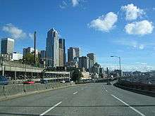
Alaskan Way Viaduct
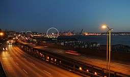
The Alaskan Way Viaduct, completed on April 4, 1953, is an elevated section of State Route 99 that runs along the Elliott Bay waterfront in Seattle's Industrial District and downtown Seattle. It is the smaller of the two major north-south traffic corridors through Seattle, carrying up to 110,000 vehicles per day.[15] The viaduct runs above the surface street, Alaskan Way, from S. Nevada Street in the south to the entrance of Belltown's Battery Street Tunnel in the north, following previously existing railroad lines.
The 2001 Nisqually earthquake damaged the viaduct and its supporting Alaskan Way Seawall and required the Washington State Department of Transportation (WSDOT) to invest US$3.5 million in emergency repairs. Experts give a 1-in-20 chance that the viaduct could be shut down by an earthquake within the next decade.[15] Since the Nisqually Earthquake occurred, semi-annual inspections have discovered continuing settlement damage.
Whether to remove, replace, or rebuild the viaduct is a politically charged issue. On March 13, 2007, voters in the city of Seattle rejected two separate proposals to replace the viaduct.[16] Eventually a plan was approved to replace the viaduct with a tunnel, with work occurring from 2011 to 2016 at an estimated cost of US$3.1 billion.[17]
Mass transit
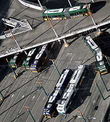
Two public transportation agencies serve the city of Seattle, King County Metro Transit and Sound Transit. Snohomish County's Community Transit also runs bus routes to Downtown Seattle and the University of Washington. Sound Transit is the regional transit authority, commissioned by voters in 1996 to build a system of light rail, express buses, and commuter rail within the Central Puget Sound area. The agency provides a number of regional express bus routes connecting Seattle with neighboring suburbs and cities. Its Sounder commuter rail system consists of two lines, linking Seattle with Tacoma along its Southern run and Seattle with Everett along its Northern run. Several stations in intermediate cities along the lines are also served. The light rail system, called Link Light Rail, includes the initial 15.7-mile (25.3 km) Central Link from downtown Seattle to Sea-Tac Airport, which began service in 2009. A 3.15-mile (5.07 km) mile extension to the University of Washington called University Link began service in 2016. Future extensions that were approved by voters in 2008 are planned to connect the University of Washington to Northgate, Lynnwood and other areas to the north; east across Lake Washington to Bellevue and Redmond; and south to Federal Way.

The Downtown Seattle Transit Tunnel is a 1.3-mile tunnel under downtown built in 1987 to relieve bus congestion along surface streets. In 2009, Link light rail trains began serving tunnel stations as part of the initial Central Link segment. The tunnel was retrofitted from 2005-2007 to accommodate light rail. All tunnel bus routes will be rerouted in 2016, making the tunnel an exclusive subway for Link trains within the city core.[18]
The city is currently in the process of expanding a modern streetcar network. In December 2007, the city inaugurated its South Lake Union Streetcar line between Westlake Center and stops in the South Lake Union neighborhood. In 2009, the Seattle city council also approved a second line to run between the Capitol Hill, First Hill, and Chinatown-International District neighborhoods.[19] The First Hill Streetcar connects First Hill to Link light rail at Capitol Hill and International District/Chinatown stations and began service in 2016 after two years of delays. Metro Transit also operated a historic Waterfront Streetcar line that ran along Alaskan Way, but the streetcar's maintenance barn was demolished to make room for the Olympic Sculpture Park, resulting in the subsequent closure of the line. King County Metro now operates a replacement bus line that mirrors the route. The proposed City Center Connector project would connect the South Lake Union and First Hill streetcars with interlined trains through Downtown Seattle.
In 2009, the ORCA Card was introduced as a new way for fare payment between the seven transit agencies in the Puget Sound region. The card uses RFID technology to handle payment from either passes, vouchers, or the E-purse, a stored value debit account. ORCA's precursor, PugetPass, will be retained as one of the several passes that can be loaded automatically onto the card. The system also calculates transfers for a two-hour window for those paying with the E-purse.
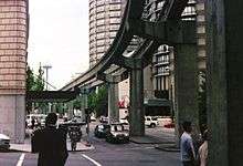
The Seattle Center Monorail, constructed for the Century 21 Exposition, runs approximately 1 mile (1.6 km) between Seattle Center in Lower Queen Anne and Westlake Center in Downtown.
Metro Transit offers a trip planner on its web site that provides information for public transit in Seattle and surrounding areas (King, Pierce, and Snohomish counties), including Sound Transit's Regional Express bus routes, Sounder commuter rail, Washington State Ferries, and the Seattle Center Monorail. Riders enter their intended origin and destination, along with optional time, date, and other information, and the trip planner displays itineraries showing the stops, departure and arrival times, and times to get from the origin to the destination. Metro Transit uploads their route schedules to Google and this has spawned a new generation of trip planners such as TransitTrips. BoltBus began offering Seattle's first curbside intercity coach service in May 2012, with Portland as its first destination.[20]
Bicycle
There are extensive multi-use car-free regional pathways linking the city and county to the surrounding areas, including the King County Regional Trails System, which has 175 miles (282 km) of trails throughout the county.[21] Many of the trails were converted from former railways, including the popular Burke-Gilman Trail. The Seattle Department of Transportation aims to develop a 608.3-mile (979.0 km) network of bike lanes, including lanes on streets, protected bike lanes, and trails, within the city by 2034.[22] An urban bike sharing system, named Pronto Cycle Share, launched in October 2014 and serves part of the city.[23]
Airports
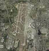

The city's primary commercial airport is Seattle-Tacoma International Airport, locally known as Sea–Tac Airport and located in the city of SeaTac, which is named for the airport. It is operated by the Port of Seattle and is served by a number of airlines connecting the region with international, national, and domestic destinations. The airport is a major hub for Alaska Airlines and its regional subsidiary Horizon Air.
Closer to downtown, Boeing Field is used for general aviation, cargo flights, and testing/delivery of Boeing airliners. In 2005, Southwest Airlines and Alaska Airlines requested permission to move passenger operations from Sea–Tac to Boeing Field but were turned down by the county.[24]
See also
References
- Peterson, Lorin; Davenport, Noah C. (1950). "Living in Seattle". Seattle: Seattle Public Schools.
- Newell, Gordon (1956). "Totem Tales of Old Seattle". Seattle: Superior Publishing Company.
Notes
- 1 2 Peterson & Davenport 1950, p. 144
- ↑ Newell 1956, pp. 73–74
- 1 2 Peterson & Davenport 1950, p. 145
- ↑ Newell 1956, pp. 73–74. Newell also writes that the entrepreneur of both the first horse-drawn streetcars and the first electric streetcars was Frank Osgood from Boston; his partners in the enterprise were Seattle pioneer David Denny and Judge Thomas Burke.
- ↑ Newell 1956, p. 106
- ↑ Peterson & Davenport 1950, pp. 145–146
- ↑ Walt Crowley (September 19, 2000). "Interurban Rail Transit in King County and the Puget Sound Region – A Snapshot History". HistoryLink.org. Retrieved September 29, 2007.
- ↑ Peterson & Davenport 1950, pp. 146–147
- ↑ Peterson & Davenport 1950, p. 148
- ↑ Metro Fares, effective January 1, 2011 King County Metro Transit. Retrieved August 27, 2011.
- ↑ Peterson & Davenport 1950, p. 50
- ↑ Peterson & Davenport 1950, p. 48
- ↑ Peterson & Davenport 1950, p. 49
- 1 2 Peterson & Davenport 1950, p. 53
- 1 2 "SR 99 - Alaskan Way Viaduct and Seawall Replacement". Washington State Department of Transportation. Retrieved September 29, 2007.
- ↑ "King County Election Results". King County. March 13, 2007. Archived from the original on March 17, 2007. Retrieved September 29, 2007.
- ↑ "SR 99 - Tunnel Project". WSDOT. Retrieved August 7, 2012.
- ↑ Gutierrez, Scott (October 16, 2009). "Bus breakdown clogs downtown tunnel at rush hour". SeattlePI.com. Retrieved October 17, 2009.
- ↑ "Seattle City Council OKs new streetcar line". The Seattle Times. October 7, 2009. Retrieved October 11, 2009.
- ↑ Lindblom, Mike (May 7, 2012). "Low-cost bus line to Portland on track to compete against Amtrak". Seattle Times. Retrieved May 8, 2012.
- ↑ "Give us your best shot: King County Parks wants trail photos for new regional trail map" (Press release). Department of Natural Resources and Parks. February 28, 2014. Retrieved September 15, 2015.
- ↑ Seattle Bicycle Master Plan, April 2014 (PDF) (Report). Seattle Department of Transportation. March 21, 2014. p. iii. Retrieved September 15, 2015.
- ↑ Trujillo, Joshua (October 13, 2014). "Seattle bike share kicks off". Seattle Post-Intelligencer. Hearst Corporation. Retrieved September 15, 2015.
- ↑ Jennifer Langston; Gordy Holt (October 12, 2005). "Plan won't fly: Sims kills Southwest's Boeing Field hopes". Seattle Post-Intelligencer. Retrieved October 19, 2007.
External links
| Wikimedia Commons has media related to Transport in Seattle. |
| Wikimedia Commons has media related to Streets in Seattle. |
- King County Metro Transit
- Alaskan Way Viaduct and Seawall Replacement Webpage
- Sound Transit Light Rail, Regional Express Bus, and Commuter Rail
- Maps for bicycle paths and routes
 | ||