Trengale
| Trengale | |
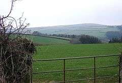 Trengale Wood and the Fowey valley |
|
 Trengale |
|
| OS grid reference | SX2102667765 |
|---|---|
| Civil parish | St Cleer |
| Shire county | Cornwall |
| Region | South West |
| Country | England |
| Sovereign state | United Kingdom |
| Police | Devon and Cornwall |
| Fire | Cornwall |
| Ambulance | South Western |
| EU Parliament | South West England |
Coordinates: 50°28′54″N 4°31′23″W / 50.48174°N 4.522988°W
Higher Trengale and Lower Trengale are two farming hamlets in the parish of St Cleer, Cornwall, England, United Kingdom. It is located to the northwest of Liskeard.[1] It is also located between Dobwalls (to the south) and Draynes (to the north). The principal river in the area is the River Fowey, which flows to the north on the other side of Trengale Wood.[2] Trengale is mentioned in the Doomsday Book. It documents a Richard holding Trengale, also referred to a Turgoil, from Saint Petroc in 1086.[3] St Neot Lower Trengale Holiday Cottages are rented out to tourists during the summer months.[4][5]
See also
References
- ↑ Country Life. Country Life, Limited. 2007. p. 219. Retrieved 30 November 2012.
- ↑ Map, Ordnance Survey
- ↑ Jankulak, Karen (2000). The Medieval Cult of St Petroc. Boydell Press. p. 204. ISBN 978-0-85115-777-1. Retrieved 30 November 2012.
- ↑ French, Dan (1 November 2004). Walk Britain: the handbook and accommodation guide of the Ramblers' Association. Ramblers' Association. p. 95. ISBN 978-1-901184-67-9. Retrieved 30 November 2012.
- ↑ The Garden. Royal Horticultural Society. 2005. p. 697. Retrieved 30 November 2012.
Cornwall Portal | |
| Unitary authorities | |
| Major settlements |
|
| Rivers | |
| Topics | |
This article is issued from Wikipedia - version of the 10/26/2016. The text is available under the Creative Commons Attribution/Share Alike but additional terms may apply for the media files.