Troina
| Troina | |
|---|---|
| Comune | |
| Comune di Troina | |
 | |
 Troina Location of Troina in Italy | |
| Coordinates: 37°47′N 14°36′E / 37.783°N 14.600°ECoordinates: 37°47′N 14°36′E / 37.783°N 14.600°E | |
| Country | Italy |
| Region | Sicily |
| Province / Metropolitan city | Enna (EN) |
| Government | |
| • Mayor | Sebastiano Fabio Venezia (since 2013) |
| Area | |
| • Total | 163.083 km2 (62.967 sq mi) |
| Elevation | 1,121 m (3,678 ft) |
| Population (2007)[1] | |
| • Total | 9,795 |
| • Density | 60/km2 (160/sq mi) |
| Demonym(s) | Troinesi |
| Time zone | CET (UTC+1) |
| • Summer (DST) | CEST (UTC+2) |
| Postal code | 94018 |
| Dialing code | 0935 |
| Patron saint | St. Sylvester |
| Saint day | June 3 |
| Website | Official website |
Troina (Sicilian: Traina) is a town and comune in the province of Enna, Sicily, Italy. It is located in the Nebrodi Park.
History
Excavations have proved that the area of Troina was settled as early as the 7th millennium BC (a farm dating from that period, and a later necropolis). Of the Greek town (most likely known as Engyon) parts of the 4th-century-BC walls remain, while from the Roman age are baths. After the fall of the Western Roman Empire it was a Byzantine stronghold and during the Islamic period the religious and moral capital of the Greek and Christian orthodox part of Sicily; Roger I of Sicily had in its castle (which he captured in 1061) also a start base of his conquest of the island.
During World War II, Troina was the seat of a battle between the Allies and the Axis forces. The town was mostly destroyed during the six-day fighting (31 July – 6 August 1943).
Twin towns
Troina is twinned with:
See also
Sources
- ↑ "The World Gazetteer". Archived from the original on 2013-02-10. Retrieved 2007-02-24.
Gallery
 Troina during World War II.
 Lake Ancipa.
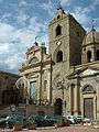 Cathedral of Maria SS Annunziata, on the right, and church of San Giorgio on the left.