Tropical Storm Haiyan (2007)
| Tropical storm (JMA scale) | |
|---|---|
| Tropical storm (Saffir–Simpson scale) | |
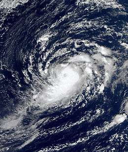 Tropical Storm Haiyan near peak intensity on October 5, 2007 | |
| Formed | September 30, 2007 |
| Dissipated | October 7, 2007 |
| Highest winds |
10-minute sustained: 75 km/h (45 mph) 1-minute sustained: 95 km/h (60 mph) |
| Lowest pressure | 994 hPa (mbar); 29.35 inHg |
| Fatalities | None |
| Damage | None |
| Areas affected | None |
| Part of the 2007 Pacific typhoon season | |
Tropical Storm Haiyan was a relatively weak and very small tropical cyclone in 2007. Forming west of the International Date Line, Haiyan was operationally considered as an extratropical cyclone by agencies and initially showed subtropical characteristics. Haiyan developed into a tropical storm with an apparent eye on October 5, although the JMA operationally upgraded it one day after. The system weakened into a tropical depression on October 6 and dissipated on the next day. Haiyan was initially not recognized by the JTWC; however, the JTWC regretted and recognized it a tropical storm in post-analysis, as well as the JMA claimed that Haiyan was always tropical in the best track data.
Meteorological history
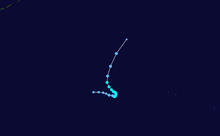
A tropical wave formed northeast of Wake Island on September 29, and a tropical depression developed from it late on September 30, which was operationally analyzed as an extratropical cyclone by the Japan Meteorological Agency (JMA) on the next day.[1][2] On October 2, the low-level circulation center shortly became fully exposed with weak convection; later, the center was gradually covered by deep convection, as the Joint Typhoon Warning Center (JTWC) best track data revealed a subtropical depression developing simultaneously.[3] The JTWC indicated that the subtropical depression transitioned into a tropical depression at noon on October 3, when deep convection over the system dissipated again.[4]
The JTWC analyzed that the system had intensified into a tropical storm early on October 4. In the RSMC best track data, the JMA analyzed that Haiyan had already intensified into a tropical storm at 00:00 UTC on October 5, yet the agency operationally reported that the system transitioned into a tropical depression with maximum sustained winds at 30 knots (55 km/h; 35 mph) at 06:00 UTC.[5] Both of the JMA and the JTWC’s best track data indicate that Haiyan had reached peak intensity since 06:00 UTC, as the storm has already formed a cloud-filled eye.[6] At noon, the JMA began to issue tropical cyclone advisories to Haiyan, expecting it to intensify into a tropical storm within 24 hours.[5]
Early on October 6, the JMA operationally upgraded the system to a tropical storm and named it Haiyan, but their post-analysis indicated that Haiyan had started to weaken and soon become a tropical depression at 06:00 UTC.[7] The agency downgraded Haiyan to a tropical depression operationally late on the same day, as well as the JTWC downgraded it to a tropical depression at the same time in best track data.[8] On October 7, Haiyan became totally exposed with a clear low-level circulation center, and Severe Tropical Storm Podul began to interact with it early on the same day, prompting Haiyan accelerating northwards.[9] Soon, the JMA declared that Haiyan had dissipated, and the remnants were later absorbed by the new extratropical cyclone transitioned from Podul. However, the JTWC analyzed that Haiyan completely dissipated late on October 7.
Nature and intensity
The Japan Meteorological Agency (JMA), which also operates the RSMC Tokyo, initially considered the predecessor of Haiyan as an extratropical cyclone; in post-analysis, the JMA reviewed Haiyan and analyzed it completely tropical throughout its life cycle, treating the predecessor as a tropical depression. Comparing to the original peak intensity of 10-minute maximum sustained winds at only 35 knots (65 km/h; 40 mph), Haiyan became slightly stronger at 40 knots (75 km/h; 45 mph) according to the RSMC best track data. Moreover, the JMA analyses that the radius of Haiyan’s gale axis was only 60 nmi (110 km; 70 mi), making it the third smallest named storm of the Northwest Pacific Ocean since the 21st century.[10]
The Joint Typhoon Warning Center (JTWC) did not recognize Haiyan as a tropical cyclone and not designate the system operationally, considering it as a subtropical low. Haiyan was even treated as an invest with 1-minute maximum sustained winds at only 20 knots (35 km/h; 25 mph) by the United States Naval Research Laboratory.[11] Conversely, the JTWC added Haiyan to the best track database and designated it as 27W, as well as the new track data indicates that Haiyan formed as a subtropical depression. In the 2007 annual tropical cyclone report, the JTWC uses two pages to review Haiyan.
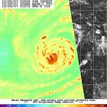
According to the JTWC, Haiyan transitioned from a mid-latitude low into a tropical cyclone, as deep convection consolidated and the winds increased closer to the center. The JTWC declares that analysis of scatterometry data between 18:00 UTC on October 3 and 12:00 UTC on October 5 supports that evolution. Besides, analysis of AMSU-A derived temperature anomaly cross-sections indicates that Haiyan completed the tropical transition, as a warm anomaly of 2°C appeared in the mid- and upper-levels, suggesting Haiyan a deep warm-core system. Based on the re-assessment of Dvorak estimates, the JTWC analyzed Haiyan’s 1-minute maximum sustained winds at 50 knots (95 km/h; 60 mph).[12]
The high-resolution MODIS visible imagery shows a possible incipient and cloud-filled eye early on October 5; besides, microwave imageries also show an apparent eye signature at the same time. As the JTWC describes, they indicate tropical cyclone characteristics. Dr. Karl Hoarau, a geographer teaching in the Cergy-Pontoise University, unofficially analyzed Haiyan a minimal typhoon with 1-minute maximum sustained winds at 65 knots (120 km/h; 75 mph), although the QuikSCAT image on October 5 supports maximum sustained winds at about only 50 knots.[13][14]
See also
References
- ↑ "Pacific Surface Analysis" (GIF). National Climatic Center. 29 September 2007. Retrieved 12 May 2014.
- ↑ "Advisories on 1 October 2007" (TXT). Mtarchive Data Server. Iowa State University of Science and Technology.
- ↑ "Observation Data for Typhoon 200716 at 2007-10-02 00:00 (UTC)". Digital Typhoon. Retrieved 12 May 2014.
- ↑ "Enhanced ifrared imagery at 1130Z on October 3" (JPEG). U.S. Naval Research Laboratory. Retrieved 24 January 2015.
- 1 2 "Advisories on 5 October 2007" (TXT). Mtarchive Data Server. Iowa State University of Science and Technology.
- ↑ Tropical Storm Haiyan 05 oct 2007 0205Z.jpg
- ↑ "RSMC Tropical Cyclone Advisory at 0000Z on October 6". Japan Meteorological Agency. Archived from the original on 6 October 2007. Retrieved 22 June 2014.
- ↑ "RSMC Tropical Cyclone Advisory at 1800Z on October 6". Japan Meteorological Agency. Archived from the original on 6 October 2007. Retrieved 22 June 2014.
- ↑ "Observation Data for Typhoon 200717 at 2007-10-07 00:00 (UTC)". Digital Typhoon. Retrieved 22 June 2014.
- ↑ "Typhoon List by Wind Information". Digital Typhoon. Retrieved 22 June 2014.
- ↑ "Track file of "Invest" 93W". The United States Naval Research Laboratory. Retrieved 22 June 2014.
- ↑ "2007 Annual Tropical Cyclone Report" (PDF). Joint Typhoon Warning Center. 2008. Retrieved 16 June 2014.
- ↑ Gary Padgett. "Monthly Global Tropical Cyclone Tracks October 2007". Retrieved 22 June 2014.
- ↑ "QuikSCAT/SeaWinds Scatterometer on 5 October 2007" (PNG). Center for Satellite Applications and Research. Retrieved 22 June 2014.
External links
| Wikimedia Commons has media related to Tropical Storm Haiyan (2007). |
- JMA General Information of Tropical Storm Haiyan (0716) from Digital Typhoon
- JMA Best Track Data of Tropical Storm Haiyan (0716) (Japanese)
- JTWC Best Track Data of Tropical Storm 27W (Haiyan)
- 27W.HAIYAN from the U.S. Naval Research Laboratory
Tropical cyclones of the 2007 Pacific typhoon season | ||
|---|---|---|
 | ||
| ||