Tsing Lung Tau

Tsing Lung Tau (Chinese: 青龍頭; literally: "Head of the green dragon") is a built-up area in the southwest coast of the New Territories in Hong Kong.
Geography
Tsing Lung Tau is located on the southwest coast of the New Territories in Hong Kong, between Sham Tseng and Tai Lam; west from Tsuen Wan and east of Tuen Mun. Tsing Lung Tau is west of the adjoining area of Sham Tseng, which is a little bit larger. The coast of Tsing Lung Tau once was a long beaches with one named Dragon Beach (青龍灣) and some tiny farmlands, however, it was reclaimed by the HKSAR Government for the widening of the Castle Peak Road in 2006.
Housing
There are three villages in Tsing Lung Tau: Tsing Lung Tau Village (青龍頭村), Tsing Lung Tau New Village (青龍頭新村) and Yuen Tun Village (圓墩村), with many villa-style developments.
The main private housing estates of the area are:
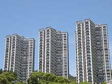
- Hong Kong Garden. 28 blocks, completed between 1986 and 2010.
- Sea Crest Villa Phase 5
- Lung Tang Court (龍騰閣). Located at 88-90 Castle Peak Road, it was completed in 1982.[1]
Built heritage
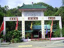
- Hong Kong Dragon Garden
- A Tin Hau Temple, located at Nos. 56-58 Castle Peak Road, was built before 1889.
Transportation
Castle Peak Road, the only major artery to Tsing Lung Tau, provides access to Tuen Mun (to the west) and Tsuen Wan (to the east).
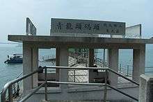
Tsing Lung Tau Ferry Pier (青龍頭碼頭) is located near the junction of Lung Yue Road and Castle Peak Road.[2] A former ferry service linking Tsing Lung Tau to Yam O has been suspended.
Bus service from KMB:
- 52x Tuen Mun Central - Mong Kok Park Avenue
- 53 Yuen Long East - Tsuen Wan Nina Tower
Bus service from Citybus:
- 962B Admiralty West - Tuen Mun Chi Lok Fa Yuen
Minibus service:
- 96M Tsuen Wan MTR - Tsing Lung Tau
- 96 Tsuen Wan Market - Tsing Lung Tau
- 302 Kwai Fong MTR - Tsing Lung Tau Hong Kong Garden
References
- ↑ Lung Tang Court at Emporis
- ↑ Film Services Office: Tsing Lung Tau Ferry Pier
| Wikimedia Commons has media related to Tsing Lung Tau. |
Coordinates: 22°21′45″N 114°02′46″E / 22.36250°N 114.04611°E