Tufanbeyli
| Tufanbeyli | |
|---|---|
 Tufanbeyli | |
| Coordinates: 38°15′52.71″N 36°13′20.63″E / 38.2646417°N 36.2223972°ECoordinates: 38°15′52.71″N 36°13′20.63″E / 38.2646417°N 36.2223972°E | |
| Country | Turkey |
| Province | Adana |
| Government | |
| • Mayor | Remzi Ergü (AKP) |
| • Kaymakam | Cevat Uyanık |
| Area[1] | |
| • District | 987.19 km2 (381.16 sq mi) |
| Elevation | 921 m (3,022 ft) |
| Population (2012)[2] | |
| • Urban | 5,742 |
| • District | 17,546 |
| • District density | 18/km2 (46/sq mi) |
| Post code | 01640 |
| Website |
www |
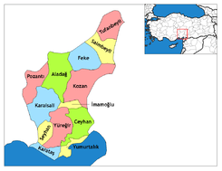
Tufanbeyli is small city and a district in Adana Province of Turkey, 196 km north-east of the city of Adana, on an uneven, sloping plateau high in the Tahtalı range of the Toros mountains. It has been bounded economically to Kayseri, 178 km far. Its neighbors are Sarız from North, Göksun from east, Saimbeyli from south, Develi from south-west and Tomarza from west.
Tufanbeyli is reached by crossing one of three high mountain passes. It's a struggle to reach but the views are incredible. The river Göksu, a tributary of the Seyhan runs across the plateau. The climate is hot dry summers and cold winters. The mountains are forested but these are steadily being consumed by the local people.
History
During the Bronze Age, the area was part of the kingdom of Kizzuwatna. In classical antiquity, the region of Tufanbeyli was in the southwestern corner of Cappadocia (while the parts of the Adana region south of Tufanbeyli were in Cilicia). The city of Comana was situated near Şarköy, some kilometers north of Tufanbeyli.
The area is now settled by descendants of Turks from the Caucasus and the Avşar (Afshar tribe; the former having come to Anatolia as a result of the Russian influx into the Caucasus in the 18th and 19th centuries. The latter being one of the group of Turkish migrants from Asia that have preserved their clan identity in Anatolia. The Avşar played a key role in the Turkish conquest of the Çukurova region and remained a local authority right up until the 19th century, especially in mountain strongholds like Tufanbeyli. Its former names were Höketçe before 1923 and Mağara between 1923-1967. It became a district in 1958 by separating from Saimbeyli.
See also
References
- ↑ "Area of regions (including lakes), km²". Regional Statistics Database. Turkish Statistical Institute. 2002. Retrieved 2013-03-05.
- ↑ "Population of province/district centers and towns/villages by districts - 2012". Address Based Population Registration System (ABPRS) Database. Turkish Statistical Institute. Retrieved 2013-02-27.