Tura, Krasnoyarsk Krai
For other places with the same name, see Tura.
| Tura (English) Тура (Russian) | |
|---|---|
|
- Rural locality - Settlement | |
|
| |
.svg.png) Location of Krasnoyarsk Krai in Russia | |
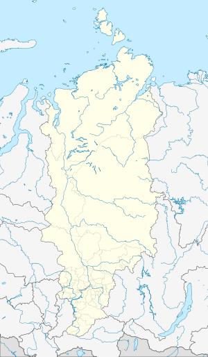 Tura | |
|
| |
|
| |
|
| |
| Administrative status | |
| Country | Russia |
| Federal subject | Krasnoyarsk Krai |
| Administrative district | Evenkiysky District |
| Administrative center of | Evenkiysky District{{{adm_ctr_of_ref}}} |
| Statistics | |
| Population (2010 Census) | 5,535 inhabitants[1] |
| Time zone | KRAT (UTC+07:00)[2] |
| Dialing code(s) | +7 39113 |
| Tura on Wikimedia Commons | |
Tura (Russian: Тура́) is a rural locality (a settlement) and the administrative center of Evenkiysky District of Krasnoyarsk Krai, Russia, located at the confluence of the Kochechum and the Nizhnyaya Tunguska Rivers. Population: 5,535 (2010 Census);[1] 5,836 (2002 Census);[3] 7,474 (1989 Census).[4]
History
Tura was the administrative center of Evenk Autonomous Okrug before the okrug was merged into Krasnoyarsk Krai on January 1, 2007. Until April 2011, it had urban-type settlement status.
Transportation
Tura is served by the Tura Airport.[5] The town and airport are linked together by the A-383 road, though Tura is currently isolated from the Russian road and railway network.
Climate
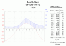
Climate Diagram
| Climate data for Tura | |||||||||||||
|---|---|---|---|---|---|---|---|---|---|---|---|---|---|
| Month | Jan | Feb | Mar | Apr | May | Jun | Jul | Aug | Sep | Oct | Nov | Dec | Year |
| Record high °C (°F) | −1.2 (29.8) |
3.3 (37.9) |
9.3 (48.7) |
18.5 (65.3) |
31.3 (88.3) |
37.6 (99.7) |
38.0 (100.4) |
32.6 (90.7) |
25.8 (78.4) |
17.2 (63) |
6.5 (43.7) |
3.0 (37.4) |
38.0 (100.4) |
| Average high °C (°F) | −30.8 (−23.4) |
−24.4 (−11.9) |
−9.6 (14.7) |
0.3 (32.5) |
9.6 (49.3) |
19.7 (67.5) |
23.9 (75) |
19.3 (66.7) |
10.3 (50.5) |
−2.5 (27.5) |
−19.5 (−3.1) |
−28.5 (−19.3) |
−2.7 (27.1) |
| Daily mean °C (°F) | −34.9 (−30.8) |
−30.2 (−22.4) |
−17.6 (0.3) |
−6.7 (19.9) |
3.8 (38.8) |
13.0 (55.4) |
16.9 (62.4) |
12.8 (55) |
4.9 (40.8) |
−6.7 (19.9) |
−23.9 (−11) |
−32.7 (−26.9) |
−8.4 (16.9) |
| Average low °C (°F) | −38.9 (−38) |
−35.1 (−31.2) |
−24.7 (−12.5) |
−13.6 (7.5) |
−1.8 (28.8) |
6.6 (43.9) |
10.3 (50.5) |
7.5 (45.5) |
0.8 (33.4) |
−10.2 (13.6) |
−28 (−18) |
−36.8 (−34.2) |
−13.7 (7.3) |
| Record low °C (°F) | −58.9 (−74) |
−59.2 (−74.6) |
−50.4 (−58.7) |
−41.6 (−42.9) |
−27.1 (−16.8) |
−5.8 (21.6) |
−1.5 (29.3) |
−5.5 (22.1) |
−15.6 (3.9) |
−39.1 (−38.4) |
−52 (−62) |
−60 (−76) |
−60 (−76) |
| Average precipitation mm (inches) | 16 (0.63) |
12 (0.47) |
12 (0.47) |
17 (0.67) |
31 (1.22) |
49 (1.93) |
57 (2.24) |
63 (2.48) |
38 (1.5) |
31 (1.22) |
24 (0.94) |
19 (0.75) |
369 (14.53) |
| Average rainy days | 0 | 0 | 0.3 | 4 | 13 | 18 | 16 | 19 | 16 | 6 | 0.2 | 0 | 91 |
| Average snowy days | 24 | 21 | 21 | 14 | 5 | 0.2 | 0 | 0.1 | 3 | 21 | 24 | 24 | 156 |
| Average relative humidity (%) | 77 | 76 | 70 | 63 | 58 | 59 | 65 | 73 | 75 | 78 | 78 | 77 | 71 |
| Mean monthly sunshine hours | 8 | 60 | 167 | 222 | 240 | 264 | 288 | 185 | 107 | 72 | 29 | 3 | 1,645 |
| Source #1: pogoda.ru.net[6] | |||||||||||||
| Source #2: NOAA (sun only, 1961-1990)[7] | |||||||||||||
References
- 1 2 Russian Federal State Statistics Service (2011). "Всероссийская перепись населения 2010 года. Том 1" [2010 All-Russian Population Census, vol. 1]. Всероссийская перепись населения 2010 года (2010 All-Russia Population Census) (in Russian). Federal State Statistics Service. Retrieved June 29, 2012.
- ↑ Правительство Российской Федерации. Федеральный закон №107-ФЗ от 3 июня 2011 г. «Об исчислении времени», в ред. Федерального закона №271-ФЗ от 03 июля 2016 г. «О внесении изменений в Федеральный закон "Об исчислении времени"». Вступил в силу по истечении шестидесяти дней после дня официального опубликования (6 августа 2011 г.). Опубликован: "Российская газета", №120, 6 июня 2011 г. (Government of the Russian Federation. Federal Law #107-FZ of June 31, 2011 On Calculating Time, as amended by the Federal Law #271-FZ of July 03, 2016 On Amending Federal Law "On Calculating Time". Effective as of after sixty days following the day of the official publication.).
- ↑ Russian Federal State Statistics Service (May 21, 2004). "Численность населения России, субъектов Российской Федерации в составе федеральных округов, районов, городских поселений, сельских населённых пунктов – районных центров и сельских населённых пунктов с населением 3 тысячи и более человек" [Population of Russia, Its Federal Districts, Federal Subjects, Districts, Urban Localities, Rural Localities—Administrative Centers, and Rural Localities with Population of Over 3,000] (XLS). Всероссийская перепись населения 2002 года [All-Russia Population Census of 2002] (in Russian). Retrieved August 9, 2014.
- ↑ Demoscope Weekly (1989). "Всесоюзная перепись населения 1989 г. Численность наличного населения союзных и автономных республик, автономных областей и округов, краёв, областей, районов, городских поселений и сёл-райцентров" [All Union Population Census of 1989: Present Population of Union and Autonomous Republics, Autonomous Oblasts and Okrugs, Krais, Oblasts, Districts, Urban Settlements, and Villages Serving as District Administrative Centers]. Всесоюзная перепись населения 1989 года [All-Union Population Census of 1989] (in Russian). Институт демографии Национального исследовательского университета: Высшая школа экономики [Institute of Demography at the National Research University: Higher School of Economics]. Retrieved August 9, 2014.
- ↑ "Tura Airport". OurAirports. Retrieved January 19, 2013.
- ↑ "Weather And Climate - Climate Tura" (in Russian). Retrieved December 18, 2012.
- ↑ "Climate Normals for Tura". National Oceanic and Atmospheric Administration. Retrieved January 19, 2013.
External links
- (Russian) History of Tura
This article is issued from Wikipedia - version of the 1/15/2016. The text is available under the Creative Commons Attribution/Share Alike but additional terms may apply for the media files.