Tutuila
|
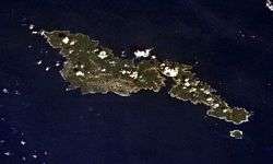
Tutuila and Aunu'u from space. | |
 | |
| Geography | |
|---|---|
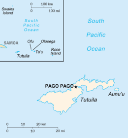
| Location | Map of Tutuila Island in American Samoa in Pacific Ocean |
| Coordinates | 14°17′42″S 170°42′00″W / 14.295°S 170.70°W |
| Archipelago | Samoan Islands |
| Area | 142.3 km2 (54.9 sq mi) |
| Highest elevation | 653 m (2,142 ft) |
| Highest point | Matafao Peak |
| Administration | |
|
United States | |
| Territory | American Samoa |
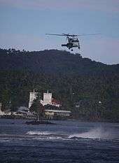
| Largest settlement | Pago Pago (pop. 11,500) |
| Demographics | |
| Population | 55,876 (2000) |
| Pop. density | 394.89 /km2 (1,022.76 /sq mi) |
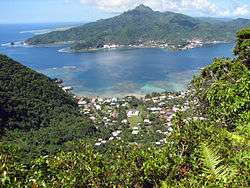
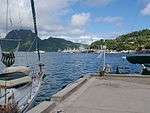
Tutuila is the largest and the main island of American Samoa in the archipelago of Samoan Islands. It is the third largest island in the Samoan Islands chain of the Central Pacific located roughly 4,000 kilometers (2,500 mi) northeast of Brisbane, Australia and over 1,200 kilometers (750 mi) northeast of Fiji. It contains a large, natural harbor, Pago Pago Harbor, where Pago Pago, the capital of American Samoa is situated. Pago Pago International Airport is also located on Tutuila island. Its land expanse is about 68% of the total land area of American Samoa and with 56,000 people accounts for 95% of its population.[1] The island has six terrestrial and three marine ecosystems.[2]
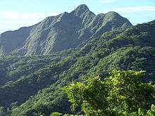
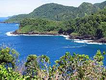
The mountainous regions (highest point at 653 meters (2,142 feet)) of the island, its beaches, coral reefs, World War II relics, and the sporting activities such as scuba diving, snorkeling and hiking activities make it attractive to tourists.[1]
Legend
A popular island legend is that, upon the issuance of a particular call, a shark and a turtle will appear. The underlying story is that, in order to escape the pangs of starvation, a blind old lady and her granddaughter jumped off a cliff in the island of Vaitogi, into the roiling ocean below. According to this legend, they were reborn as a shark (old lady) and a turtle (young girl). In support of this legend, the villagers utter a particular chant by which the shark and the turtle promptly make an appearance.[3]
Another Samoan legend is the Flying Fox, found in the National Park of American Samoa in Tutuila. The belief is that the Flying Fox (actually a bat) is the protector guardian of the forest, and its people.[4]
History
The Polynesians first reached Samoa at about 10,000 BC. By 600 BC, they had established a settlement on Tuta at Tula. [5] They built up a settlement at Tula. Over the centuries, the Samoans kept in contacts with the neighboring islands of Western Polynesia, Tonga and Fiji.
In 1722, Jacob Roggeveen became the first European to visit the Manu'a islands and in 1768 the islands of Samoa were named the "Navigator Islands" by Louis Antoine de Bougainville because of the fact that the islanders used canoes offshore to catch tuna.[6] Whalers and Protestant missionaries began to arrive in the early 19th century, particularly in the 1830s, including John Williams of the London Missionary Society. Apia, rather than Pago Pago developed as a trading station.[6] Louis de Freycinet arrived in October 1819 and named Tutuila Rose Island after his wife.[6]
In 1872, the Pago Pago Harbor was recognized by the Americans as the ideal refueling station for the new San Francisco to Sydney steamship service.[5] In 1872, the US Navy negotiated a treaty on Tutuila to use the island but didn't ratify it until 1878.[5] Due to competing interest from Great Britain and Germany which began to emerge in the 1860s, in 1879 the Americans formed a tripartite government of the islands after the Samoans declared that they are open to all of them.[6]
The Berlin Conference of 1889 was held to discuss the political future of the islands but, by 1899, American dissatisfaction of not having complete control led to a division of the Samoan islands, with Tutuila and Aunu'u forming American Samoa. The Samoans signed the agreement in 1900 and the Flag of the United States was raised on Tutuila on April 17, 1900.[6] It wasn't until 1929 though that it was formally ratified and the name of American Samoa wasn't given formally until 1911.[5][6]
During World War II, Tutuila was an important island for the US Marines in the Pacific and they erected many concrete bunkers along the coastline. The island, given that it was such an important base went relatively unscathed during the war, except for an attack from a Japanese submarine on January 11, 1942.[5] Since 1951, the island and American Samoa has been the responsibility of the Department of the Interior.[5]
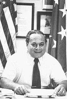
In 1956 Peter Tali Coleman became the first Samoan-born governor and during his term protection for the islanders against the alienation of their lands and loss of culture was approved in 1960 and subsequently the Flag of American Samoa became official.[6] In 1961, President John F. Kennedy appointed H. Rex Lee and generated massive funds to develop Tutuila, financing the building of an international airport, port facilities, roads, schools, houses, a hospital, a tuna cannery, a modern hotel and installing electricity throughout the 1960s.[5] This massive development came at the exact time that the political future of American Samoa was uncertain given that Western Samoa became independent of New Zealand in 1962 and effectively stamped American authority over Tutuila as a dependency.
In July 1997 Western Samoa, by legal agreement, changed the country's name from Western Samoa to Samoa. This was opposed by the Americans, including the American Samoan islanders who believed that the name diminished their sense of identity and still use the terms Western Samoa and Western Samoans.
Today American Samoa is an unincorporated and unorganized territory of the US but is under the administration of the Office of Insular Affairs of the US Department of the Interior. Politically, the island is divided into two of American Samoa's primary divisions, the Eastern District and the Western District.[7]
Geography
Tutuila lies in the Pacific Ocean, roughly 4,000 km (2,500 mi) northeast of Brisbane, Australia.[8] The town of Fagatogo is situated 1,238 km (769 mi) northeast of Suva, Fiji.[8] The island lies roughly 530 km (330 mi) north of Niue and roughly 580 km (360 mi) south of Tokelau and roughly 100 km (62 mi) southeast of the Samoan island of Upolu.[8]
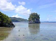
Tutuila is a fairly small and narrow island, measuring roughly 33 km (21 mi) across and little more than 3 mi (4.8 km) from north to south at its widest point.[9] The area of this volcanic island of early Pliocene age is 142.3 km2 (54.9 sq mi) with a shore line of 101.3 km (62.9 mi). The hill range which runs from west to east is rugged and winding with the northern coast line having steep cliffs and unusual coast line. However, the southern part of the island has flatter terrain. Good beaches are located at many places along the coast. It has a wet tropical climate. The highest point in the Tutuila island is the Matafao Peak which is at an elevation of 653 meters (2,142 ft), which is highest peak in the island. There is trail opposite to the Mount Alava peak (483 km (300 mi)) which dominates the northern part of the island.[9] This 9.7 km (6.0 mi) trail is approached by a metal stairway from the southern end which goes right up to the peak.[9] Trekking along the ridge through the rain forests without any additional support system, the scenic beauty of the South Pacific Ocean provides a delightful sight.[1][2]
In the early 19th century, navigators passed through the Tutuila, the westward island among the Samoan group of Islands (one of the four islands called as navigators islands), when it was also known by the names of Bougainville, Manuo or Maouna. Midway between this islet and the rock the navigators sighted the Pago Pago harbor, which was marked by "a conical hill on its western side and a flat elliptical topped hill to the eastward." Leone village, large and prosperous, was sighted to the west of the island. To the south-east of the island is the Aunu'u islet.[10]
The coastal road runs for a length of 50 km (31 mi) from Fagamalo in the northwest to Onenoao in the far northeast.[4] Important towns and villages now developed in the island are: Fagatago, the largest town with government offices functioning from Utulei (both are urban centers located to the northeast of Pago Pago[4]); Pago Pago (a deep harbor that divides the island into two parts[4]), the harbor town opposite to Fagatago; the Vatia village on the northern coast known for its famous beach and scenic setting, which is also a coral fringed bay; and Leone, a safe anchorage station in the past where the Europeans and Samoans first started their interaction in the early years of the island's history.[1][4] The southwestern-most settlement is Taputimu, the western-most settlements are Poloa and Amanave, the northern-most settlement is Vatia and the eastern-most settlement is Tula.[11][12]
Demographics
The island has population of 55,876 (2000 census) (These figures include Aunu'u Island, off the southeast coast of Tutuila, which has a land area of 1.517 km2 (0.586 sq mi) and a population of 476).[7]
Economic activity
The economy of American Samoa is dominated by grants from the U.S. Department of Interior. The tuna canning and fishing industries provide the majority of the GDP, although tourism is a promising developing sector. Economic activity is strongly linked to the US with which American Samoa conducts most of its commerce,[13] although American Samoa does not treat the US as an external trade partner. Funding from the US government adds substantially to American Samoa's economic well being. Attempts by the government to develop a larger and broader economy are restrained by Samoa's remote location, its limited transportation, and its devastating hurricanes. Hurricanes are relatively infrequent and although they sometimes cause substantial damage, the total number of deaths from hurricanes in the past 50 years is estimated to be less than 5. Therefore, hurricanes are simply an inconvenience and certainly not the economic development curtailing events portrayed in many writings.
More than 90% of the land is communally owned. Tuna fishing and tuna processing plants are the backbone of the private sector, with canned tuna the primary export.[13] Urban development has taken roots in Pago Pago Harbor where fisheries and its allied industries of canneries have been established. The largest Tuna processing plant in the world, known as StarKist, is located in Atu'u, across the bay from Fagatogo.[1][2] In the harbor there is a workshop of the Marine Railways, which takes care of the maintenance and repair of fishing ships.
Ecosystem
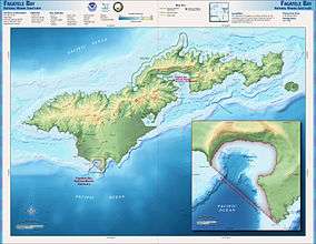
The island has six terrestrial and three marine ecosystem. There are two protected areas in the island namely, the National Park covering an area of 2,000 hectares (4,900 acres) and the Fagatele Bay National Marine Sanctuary of 66 hectares (160 acres) area.[2][14]
Flora
Flora in the island is dominated by lowland and montane rain forests. The lowland rain forest at elevation less than 300 m (980 ft) is dominated by Diospyros, Dysoxylum, Pometia and Syzygium species. The montane forest in the elevation range of 300–700 m (980–2,300 ft) consists of Dysoxylum, montane scrub, streams, bushes, mangroves, mangrove lagoons, reefs and submerged coral banks.[2]
Fauna
There are 19 species of land snails in the island out of which 11 are endemic and four are in the threatened category.[2] Mt. Matafao, which has many species of snails, has been researched from this angle since 1917; some of the endemic snails reported here are the Diastole matafaoi (endemic and may be extinct) and Samoana abbreviata (short Samoan tree snail, Partulidae). Achatina fulica (giant African land snail) introduced in 1975 is reported to have damaged gardens.[2] Two different species of flying fox (bats) have also been found on the island (described under National Park).[14]
- Aquafauna
Hard corals recorded are 174 species of 48 genera and sub-genera.[2]
- Avifauna
The bird species recorded are under endemic category. These are: The Aplonis atrifuscus (Samoan starling) group; the Gymnomyza samoensis (black-breasted honeyeater) group; Halcyon recurvirostris (flat-billed kingfisher); Lalage sharpei (Samoan triller); Myiagra albiventris (white-vented flycatcher); Pachycephala flavifrons (yellow-fronted Samoan whistler); and Rhipidura nebulosa (Samoan fantail).[2]
Four species of native doves and pigeons are also recorded in all the islands of Samoa. The four species are: Pacific imperial pigeon (Ducula pacifica), the crimson-crowned fruit dove (Ptilinopus porphyraceus), many-coloured fruit dove (Ptiliopus persousii) and shy ground dove (Galicolumba stairi).[14]
Butterflies are another category of avifauna in the island. The recorded species are: the Hypolimnas thompsoni and Papilio godeffroyi (butterfly).[2]
National Park of American Samoa
The National Park of American Samoa in Tutuila was established in 1988 for preserving its perfect terrestrial and marine environment. It covers an area of 2,000 ha (4,900 acres)[2] and is bound on the north coast between Fagasa and Afono villages. The Rainmaker pass is located within this park with its rain forests. The Amalau valley between the Afono and Vatia villages in the park has many species of birds and animals. The most significant faunal species consists of the two species of the flying fox (bats), which the local Samoans consider as the protector guardian of the forest and also its people.[15]
The two species of flying foxes (bats) protected in the park are: Pteropus samoensis (known locally as pe'a voa) meaning "fruit bat of the forests" and Pteropus tonganus locally called pe'afaunua, which means "fruit bat of settled lands"; The roosting place of Pteropus samoensis (with prominent light colored face with brown body) is the canopy of ridge top trees, which roost alone or in small groups and are active during day time with two feeding peaks, the Pteropus tonganus (with black colored face with seal brown body) species roost in large groups (100 or more in numbers in each group) in thick forest habitat, also sometimes seen close to villages. Both species have a wing span of 1 m (3 ft 3 in) at adulthood, and weigh about 500 grams.[14][15]
The park which is divided into three zones has a network of hiking trails. The National Park Service (NPS) maintains good information system about these trails. One such trail goes up the Mount Alava, a high peak within the park rising to a height of 491 metres (1,611 feet). A TV tower exists on this mountain and also the ruins of a cable car station of a 1.8 km (1.1 mi)[15] long cable way which once ran over Pago Pago Harbor to Solo hill in Utulei. (524m[1]). This cable way, which was the only single way cable in the world at that time built in 1965, was damaged when a Navy plane attempted to fly under it and was caught by one of the cables, on April 17, 1980 and was permanently put out of commission. The cable way was used to transport the TV technicians to the transmission station. The descent from the peak passes through lovely vistas of the lowlands of the park and the rain forests which abounds in several bird species. Another ridge trail runs from Fagasa Pass over a length of 6.5 km (4.0 mi), goes through a very steep slopes behind the rest fale (hurricane shelter), which is also negotiated through a stairway and further leads down to the serene Vatia village on the coral bay.[15]
Natural disasters

Hurricanes or tropical cyclones have been frequently striking the Samoan Island for centuries. To monitor and give advance warning of the cyclones, several Observation stations have been established under the U.S. Federal Emergency Management Agency (FEMA), in American Samoa. After the first recorded hurricane (at least in modern times) hit the Samoan islands on February 10, 1966, which was declared a major disaster, "hurricane homes" called as "fale afa" have been built in the islands for people to take shelter during cyclonic storms. After the hurricane in 1966 the islands have witnessed many disasters due to heavy rains, hurricanes and drought; due to drought in 1974, due to floods, mudslides and landslides in 1979; and due to hurricanes in 1981, 1987, 1990, 1991 and 2004; and a tsunami in 2009.
The hurricane of December 4–13, 1991 was the worst disaster faced by entire group of Samoan Islands which was named "Hurricane Val," which caused immense damages to property in the American Samoa and Western Samoa.[16] The Hurricane Val in comparison to past hurricanes, was very severe and the storm force had a wind velocity of over 100 knots or 166 km (103 mi)/hour. It was reported as the worst in 100 years in its intensity of wind force and the severity of the damage caused in the island.[17] According to the history of the National Oceanic and Atmospheric Administration's (NOAA) American Samoa observatory, "Hurricane Val" struck the Tutuila Island from December 7 – 10th. The hurricane's eye passed over the southern end of the island with winds as high as 116 mi (187 km) recorded at the observatory. In the Fagatele Bay of the Tutuila Island where the Hurricane Val made a direct pass over Tutuila the coral reef was completely destroyed, a large strip of the coast was also eroded.
In response to this disaster, National Oceanic and Atmospheric Administration (NOAA) dispatched an assessment team to survey the damage to the reefs.[18] Apart from the cable way which was severely damaged and went permanently out of commission, the TV tower at Utulei, one of the three TV channels, was completely damaged by Val, resulting in its cannibalization to maintain the two remaining channels. The Fagalele Boys School, which was one of the oldest European style buildings built in the middle of the 19th century on the west coast of the island in Leone village, was also destroyed by Hurricane Val.[19]
Places of historical interest
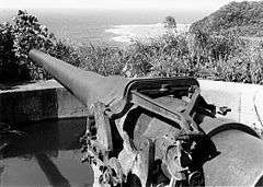
At Utulei, at Blunts Point there are two guns of World War II vintage dated to 1941, which are seen in the form of two metal tubes projecting from a wall. The guns are seen at two levels, the lower gun is above a green water tank. The second gun is located 200 m (660 ft) above the first gun above the ridge. Both guns are accessible through a staircase made of concrete. In addition, two more guns of identical dimensions are also seen fixed at the harbor mouth at a strategic location to create a cross fire. Concrete bunkers used during WWII are also seen at Pago Pago.[1]
Notable buildings in Fagatogo are the Governor's Mansion (1903), Sadie's Restaurant where Somerset Maugham stayed in 1916 and wrote the short story "Rain" about former prostitute Sadie Thompson (that takes place in American Samoa), the Fono Building which is the state legislative building, the Jean P. Haydon Museum built in 1917, which was once the navy headquarters and Catholic Cathedral with painting of a Holy Family scene at the beach. Also seen are the Zion Church (1900) at Leon, the old capital of Tutuila and the monument in front of the church erected in honor of John Williams, the first missionary to visit Tutuila in 1832, the Radio Towers at Mt. Olotele, the Massacre Bay in Assau village where a monument has been installed in 1883 with stone cross to honor of the 11 French sailors only who were members of the Astrolabe and Boussole ships during the La Parouse expedition who were killed by the local Samoans in a clash on December 11, 1787; 11 Chinese and 39 Samoans also died in this conflict but are not mentioned in the honor list.[20]
At the defunct cable car terminal on the Solo Hill there is monument built in honor of the six US Navy personnel who died in the plane crash which occurred as a result of hitting the cable way and crashed into the Rainmaker Hotel; two tourists staying in the hotel also died in the crash.[1]
See also
Notes
- 1 2 3 4 5 6 7 8 Stanley, David (2004). Moon Handbooks South Pacific. David Stanley. p. 475. ISBN 978-1-56691-411-6. Retrieved December 18, 2010.
- 1 2 3 4 5 6 7 8 9 10 11 "Islands of American Samoa (United States)". Tutuila (391). UN System-Wide Earthwatch Web Site. Retrieved November 24, 2010.
- ↑ Stanley, p.480
- 1 2 3 4 5 Dragicevich, Peter; Craig McLachlan (2009). Lonely Planet Samoa & Tonga. Lonely Planet. pp. 84–85. ISBN 978-1-74104-818-6. Retrieved December 18, 2010.
- 1 2 3 4 5 6 7 David Stanley (1985). South Pacific handbook. David Stanley. pp. 230–. ISBN 978-0-918373-05-2. Retrieved 21 December 2010.
- 1 2 3 4 5 6 7 Brij V. Lal; Kate Fortune (2000). The Pacific Islands: an encyclopedia. University of Hawaii Press. pp. 560–. ISBN 978-0-8248-2265-1. Retrieved 21 December 2010.
- 1 2 "Tutuila: Eastern District and Western District". United States Census Bureau. Retrieved December 19, 2010.
- 1 2 3 "Travel distance calculator between cities". Map Crow. Retrieved December 19, 2010.
- 1 2 3 Holly Hughes, Alexis Lipsitz Flippin, Julie Duchaine, Sylvie Murphy (2009). Frommer's 500 Extraordinary Islands. Frommer's. p. 86. ISBN 978-0-470-50070-5.
- ↑ The Nautical magazine. Fisher, Son & Co. 1840. p. 754. Retrieved December 19, 2010.
- ↑ Google Maps (Map). Google.
- ↑ Bing Maps (Map). Microsoft and Harris Corporation Earthstar Geographics LLC.
- 1 2 "Economy of American Samoa". Nation Master Encyclopedia. Retrieved December 19, 2010.
- 1 2 3 4 "Effect of Cyclone Val on areas proposed for inclusion in the National Park of American Samoa" (PDF). A report to the U.S. National Park Service. Botany.hawaii.edu. pp. 3–4. Archived from the original (PDF) on January 4, 2012. Retrieved December 18, 2010.
- 1 2 3 4 Dragicevich, p.88
- ↑ "FEMA posts 11 disaster declarations for territory over last 40 yrs". Samoanews. November 4, 2010. Retrieved December 18, 2010.
- ↑ Ward, R. Gerard; Paul Ashcroft (1998). Samoa: mapping the diversity. [email protected]. pp. 17–21. ISBN 978-982-02-0134-7. Retrieved December 17, 2010.
- ↑ "Fagatele Bay Marine Sanctuary". Research and Monitoring. Official Site of the Fagatele Bay National Marine Sanctuary. Retrieved December 17, 2010.
- ↑ Stanley, pp. 475–477
- ↑ Stanley, pp. 479–481
References
| Wikimedia Commons has media related to Tutuila. |
- Siebert L, Simkin T (2002-). Volcanoes of the World: an Illustrated Catalog of Holocene Volcanoes and their Eruptions. Smithsonian Institution, Global Volcanism Program Digital Information Series, GVP-3, (http://www.volcano.si.edu).
- Tutuila: Eastern District and Western District, United States Census Bureau
| Topics | |
|---|---|
| Geography | |
| Politics | |
| Economy | |
| Culture | |
| Districts | |
| Islands | |
| Villages |
|