Uchee, Alabama
| Uchee, Alabama | |
|---|---|
| Unincorporated community | |
 Uchee, Alabama  Uchee, Alabama | |
| Coordinates: 32°21′03″N 85°21′53″W / 32.35083°N 85.36472°WCoordinates: 32°21′03″N 85°21′53″W / 32.35083°N 85.36472°W | |
| Country | United States |
| State | Alabama |
| County | Russell |
| Elevation | 541 ft (165 m) |
| Time zone | Central (CST) (UTC-6) |
| • Summer (DST) | CDT (UTC-5) |
| Area code(s) | 334 |
| GNIS feature ID | 157184[1] |
Uchee, also known as Spains Stand, is an unincorporated community in Russell County, Alabama, United States. Uchee is named after the nearby Uchee Creek, which in turn is named for the Yuchi tribe.[2] The word "yuchi" probably means "at a distance" in the Yuchi language, with yu meaning "at a distance" and chi meaning "sitting down".[3] The Yuchi lived in the area around present day Russell County, Alabama and Fort Benning, Georgia, before being removed to the Indian Territory. The Uchee Methodist Church is listed on the National Register of Historic Places. A post office was operated in Uchee from 1835 to 1907.[4]
Demographics
| Historical population | |||
|---|---|---|---|
| Census | Pop. | %± | |
| 1880 | 63 | — | |
| U.S. Decennial Census[5] | |||
Uchee appeared on the 1880 U.S. Census as an unincorporated community of 63 residents. This was the only time it appeared on the census rolls.
Notable people
- Johnny Allen, R&B arranger and pianist
- William Henry Denson, U.S. Representative from 1893 to 1895
References
- ↑ "Uchee". Geographic Names Information System. United States Geological Survey.
- ↑ History of Alabama - Albert James Pickett - Google Books. Books.google.com. Retrieved 2014-07-13.
- ↑ Read, William A. (1984). Indian Place Names in Alabama. Tuscaloosa: The University of Alabama Press. p. 74. ISBN 0-8173-0231-X.
- ↑ "Russell County". Jim Forte Postal History. Retrieved 20 November 2014.
- ↑ "U.S. Decennial Census". Census.gov. Retrieved June 6, 2013.
Municipalities and communities of Russell County, Alabama, United States | ||
|---|---|---|
| City | 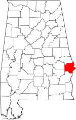 | |
| Town | ||
| CDP | ||
| Unincorporated communities | ||
| Former city | ||
| Footnotes | ‡This populated place also has portions in an adjacent county or counties | |