Uchinada, Ishikawa
| Uchinada 内灘町 | |
|---|---|
| Town | |
| 内灘町 ・ Uchinada Town | |
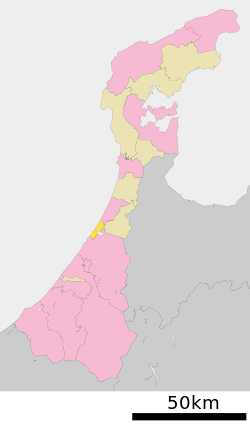
 Location of Uchinada in Ishikawa Prefecture | |
 Uchinada Location of Uchinada in Ishikawa Prefecture | |
| Coordinates: 36°39′1.77″N 136°38′53.12″E / 36.6504917°N 136.6480889°ECoordinates: 36°39′1.77″N 136°38′53.12″E / 36.6504917°N 136.6480889°E | |
| Country | Japan |
| Region |
Chūbu Hokuriku |
| Prefecture | Ishikawa Prefecture |
| District | Kahoku |
| Established | 1962 |
| Government | |
| • Mayor | Yasode Yasunari 八十出泰成 |
| Area | |
| • Total | 20.38 km2 (7.87 sq mi) |
| Elevation | 20 m (70 ft) |
| Population (December 31, 2009) | |
| • Total | 26,787 |
| • Density | 1,311.0/km2 (3,395/sq mi) |
| Time zone | Japan Standard Time (UTC+9) |
| Area code(s) | 076 |
| Town symbols | |
| • Tree | Japanese black pine |
| • Flower | Japanese rose |
| • Bird | Eastern marsh harrier |
| Address |
1-2-1 Daigaku, Uchinada-machi, Kahoku-gun, Ishikawa-ken 920-0292 |
| Website |
www |
Uchinada (内灘町 Uchinada-machi) is a small beach town located in Kahoku District, Ishikawa Prefecture, Japan. It is a suburb of Kanazawa, the capital of Ishikawa Prefecture.
Demographics
As of December 31, 2009, the town has an estimated population of 26,787 and a density of 1,311 persons per km2. The total area is 20.38 km2.
The town's population rose to 10,000 in 1969, exceeding 20,000 in 1979, and has continued to rise since then.
The birthrate is 0.57 babies per day (208 babies per year).
The mortality rate is 0.52 persons per day (189 persons per year).
15.4 percent of the population (4,115 persons) are aged 14 and younger.
18.3 percent of the population (4,901 persons) are aged 65 and above.
Town Logo
Uchinada's town logo is a stylized version of the Japanese character "u" (う) representing the town's name. Its circular shape symbolizes a single ring of connectedness in the community, as well as the town's progress into the future.
Town tree: Japanese black pine
As a town built upon sand dunes, windblown sand in Uchinada was once a major source of distress. The Japanese black pines, which are planted along the coastline, serve as a protective wall against sand and wind.
Town bird: eastern marsh harrier
The harrier, which makes its home in the areas surrounding the Kahoku Lagoon, is said to be valiant and wise. Its figure in mid-flight symbolizes the town's rapid progress into the future.
Town flower: Japanese rose (rugosa)
While the rose may seem beautiful and elegant, it also possesses traits of endurance and strength through severe conditions.
Geographical Features
Uchinada sits in a typical seaside sand-dune environment, lacking any major mountains or rivers, with an average elevation of 20 meters. The highest point of elevation reaches 58.51 meters, with a dynamic landscape formed by the constant forming and reforming of sand dunes, both new and old. Along the edge of the sand dunes, there are remnants of black soil dating from the end of the Jomon Period to the beginning of the Kofun Period.
The town is bordered on the west by the Sea of Japan, on the south by Kanazawa City, on the east by Tsubata Town and the Kahoku Lagoon, and on the north by Kahoku City.
East-West span: 2.9 km North-South span: 9.0 km
World Kite Festival
Uchinada is internationally known for its World Kite Festival which occurs annually on May 3 and 4. People from around Japan and the world gather on the shores of Uchinada's beaches every year to fly kites during this festival. The 2011 World Kite Festival was cancelled out of solidarity for the victims of the Great Eastern Japan Earthquake Disaster, which happened on March 11, 2011.
Acacia Romantic Festival
This festival occurs every year in mid-May when the blossoms from the false acacia trees shielding the town from sand and wind are in full bloom. It consists of a flea market on the 2.1 km Forest Promenade in the morning and a series of performances by various associations in the town at the nearby Hamanasu Dinosaru Park starting at noon.
Uchinada Multipurpose Park
Along with a variety of sports facilities, such as tennis courts, a baseball field, ground golf range, and a heated indoor pool, the park's giant pirate ship playground (named the "Sunset Ship"), barbecue pits, and observation tower make this one of the most popular spots in the town. Besides that, there are 71 parks in the town and 17 community halls.
Uchinada's History and Development
Remains of earthenware pots found in the sand dunes of Uchinada reveal the existence of humans living in the area since the Jomon period. The area continued to be settled since the Middle Ages, but the name "Uchinada" did not appear in history books until 1952, with the occurrence of the United States Military Firing Ground Condemnation Conflict. The condemnation and opposition movement associated with this conflict were referred to as "The Uchinada Battle," which continued until the complete withdrawal of the United States military in the area in 1957. Stagnation in the fishing industry, a major source of life support for the townspeople, led to the redevelopment of an agricultural promotion policy and the execution of the Kahoku Lagoon Land Reclamation Project. Uchinada was officially established as a town in 1962, and with the ensuing changes to its industrial structure, the town has continued to be vitalized by its domestic industrial fiber industry, and the development of residential areas.
The Medical School of Kanazawa is located in Uchinada.
External links
- Official website (Japanese)
- Pictures of Uchinada World Kite Festival (English)
- Kanazawa Medical School located in Uchinada In Japanese and English