Hōdatsushimizu, Ishikawa
| Hōdatsushimizu 宝達志水町 | ||
|---|---|---|
| Town | ||
| ||
|
Location of Hōdatsushimizu in Ishikawa Prefecture | ||
 Hōdatsushimizu Location in Japan | ||
| Coordinates: 36°52′N 136°48′E / 36.867°N 136.800°ECoordinates: 36°52′N 136°48′E / 36.867°N 136.800°E | ||
| Country | Japan | |
| Region |
Chūbu Hokuriku | |
| Prefecture | Ishikawa Prefecture | |
| District | Hakui | |
| Area | ||
| • Total | 111.68 km2 (43.12 sq mi) | |
| Population (August 2011) | ||
| • Total | 14,741 | |
| • Density | 130/km2 (340/sq mi) | |
| Time zone | Japan Standard Time (UTC+9) | |
| Website |
www | |
Hōdatsushimizu (宝達志水町 Hōdatsushimizu-chō) is a town located in Hakui District, Ishikawa Prefecture, Japan. It is one hour from Kanazawa, Ishikawa by Nanao Line.
Hōdatsushimizu was formed March 1, 2005 from the merger of the towns of Oshimizu and Shio, both from Hakui District. Hōdatsushimizu is named after Mount Hōdatsu, the highest mountain in the Noto Peninsula and a compound of former names (Shio + Oshimizu).
As of August 2011 population data, the town has a registered population of 14,741.[1] The total area is 111.68 km².
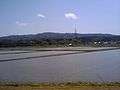
Hōdatsushimizu is famous for Mount Hōdatsu, Hōdatsu-kuzu and Chirihama nagisa driveway, the only tourist highway on a sandy beach in Japan. Paleolith tools have been dug up in Hōdatsushimizu.
In Hōdatsushimizu, there are the Houdatsu and the Shio libraries.
 Mount Hodatsu
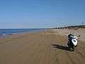 Chirihama-Nagisa drive-way
References
- ↑ お知らせ > 宝達志水町の人口(平成23年8月末). Hōdatsushimizu official website (in Japanese). Hōdatsushimizu Town. Retrieved September 22, 2011.
External links
 Media related to Hōdatsushimizu, Ishikawa at Wikimedia Commons
- Official website (Japanese)