Uludere
| Uludere | |
|---|---|
 Uludere | |
| Coordinates: TR 37°25′0″N 42°54′0″E / 37.41667°N 42.90000°ECoordinates: TR 37°25′0″N 42°54′0″E / 37.41667°N 42.90000°E | |
| Country |
|
| Province | Şırnak |
| Government | |
| • Mayor | Zeynep Üren (BDP) |
| • Kaymakam | Naif Yusuf |
| Area[1] | |
| • District | 731.30 km2 (282.36 sq mi) |
| Population (2012)[2] | |
| • Urban | 10,013 |
| • District | 38,201 |
| • District density | 52/km2 (140/sq mi) |
| Post code | 736xx |
| Website |
www |
Uludere is a district in Şırnak Province, Turkey.
Geography
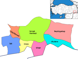
Uludere's total land area is 825 km². Its neighbors are Cukurka, the province of Hakkari to the east; the districts of Sirnak and Silopi to the west; the district of Beytussebap to the north and the nation of Iraq to the south. Uludere is approximately 56 km from the Iraq border.
The topography of Uludere consists mostly of rugged mountainous terrain. The highest mountains are Altın Tepe, Mührina Dağları, and Tanintanin Dağları. A small stream which is a tributary of the Hezil River, runs through the center of the village.[3]
Climate
Uludere has a continental climate. Summer season is hot and dry, while winter season is cold and rainy.
Population
Ninety-five percent (95%) of the population of Uludere is Bölgenini. The most populous tryibe is Goyan, which includes members who are Kurds.
History
The Urartu, the Medes, the Persians, the Romans, and the Sassanids are the early invaders of this land. Eventually the region fell under the rule of the Arsacid Dynasties. In 1260, the Hulagu Hakkari region was attacked by Imadeddin Zengi'in and endured years of tumult. The local rulers were forced to accept Karakoyunlu leadership in 1349. Uludere came under Timurid and Safavid rule in 1386.
In 1502 Uludere (Kılaban), was governed by Suleiman the Magnificent of the Ottoman Empire in its internal affairs, such as connecting all provincial lords. Protection was given to the sovereign rights of tribal princes, except that the Ottoman land system dominated. The empire could also demand the sending of troops to support their campaigns. The Sindi tribe dominated the region during the Ottoman period.
After the proclamation of the Turkish republic, Uludere turned into a parish connected with the town of Beytussebap. With Law No. 7033, enacted on 27 June 1957, the area became part of the Hakkari province, and remained so until 1990. (Çölemerik) was a district of the province. Law No. 3474, issued on 16 May 1990, put the village in the newly founded province of Sirnak. The distance from the city center district of the province of Sirnak Uludere 48 km long. There are 12 villages and three towns connected to the district. Uludere Municipality was established in 1958.
Nature
An important cultural element of the province of Şırnak is a rich folklore based on the natural world around them. There are many areas of natural beauty to visit, in particular the Irmaklarıyla Highlands. Houses built from the soil in this region still exist and are considered a rare architectural sight. Uludere is a town rich in local flora and fauna. In spring, Lusi, Kerenk, as well as many different edible plants and vegetables, can be collected in the Pıncar Highlands. In the summer, Işgın and Temtol plants from the pastures provide a good food-source. All are also sold locally in bazaars. There are numerous endemic plant species such as tulips and mountain Lalesidir. Uludere inverted-tulips, or mountain tulips as they are also known, only grow in the mountains of Hakkari, and are protected by law. They are regarded as the symbol of the township. There has been research conducted into the extinction of the Anatolia Caspian tiger in the area, with the last one being seen in February 1970. Many other species still exist in the area, including mountain goats, bear, wild boar, deer, rabbits, foxes, partridges and numerous other bird species. Tourism, especially in the winter, is economically important to the area.
See also
References
- ↑ "Area of regions (including lakes), km²". Regional Statistics Database. Turkish Statistical Institute. 2002. Retrieved 2013-03-05.
- ↑ "Population of province/district centers and towns/villages by districts - 2012". Address Based Population Registration System (ABPRS) Database. Turkish Statistical Institute. Retrieved 2013-02-27.
- ↑ http://travelingluck.com/Asia/Turkey/%C5%9E%C4%B1rnak/_298433_Uludere.html/