Unadilla, Georgia
| Unadilla, Georgia | |
|---|---|
| City | |
|
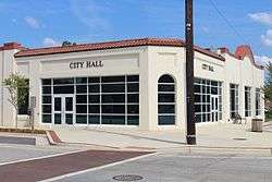
City Hall in Unadilla | |
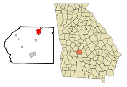 Location in Dooly County and the state of Georgia | |
| Coordinates: 32°15′35″N 83°44′12″W / 32.25972°N 83.73667°WCoordinates: 32°15′35″N 83°44′12″W / 32.25972°N 83.73667°W | |
| Country | United States |
| State | Georgia |
| County | Dooly |
| Government | |
| • Mayor | Myron Mixon |
| Area | |
| • Total | 6.1 sq mi (15.8 km2) |
| • Land | 6.1 sq mi (15.7 km2) |
| • Water | 0.04 sq mi (0.1 km2) |
| Elevation | 427 ft (130 m) |
| Population (2010) | |
| • Total | 3,796 |
| • Density | 579/sq mi (223.4/km2) |
| Time zone | Eastern (EST) (UTC-5) |
| • Summer (DST) | EDT (UTC-4) |
| ZIP code | 31091 |
| Area code(s) | 478 |
| FIPS code | 13-78156[1] |
| GNIS feature ID | 0333297[2] |
Unadilla is a city in Dooly County, Georgia, United States. The population was 3,796 at the 2010 census,[3] up from 2,772 at the 2000 census. The name is a native term for "gathering place". Dooly State Prison is located in the northeast corner of the city.
History
The community was incorporated in 1891.
Geography
Unadilla is located in northern Dooly County at 32°15′35″N 83°44′12″W / 32.259796°N 83.736535°W.[4] U.S. Route 41 passes through the center of town as Pine Street, leading north 16 miles (26 km) to Perry and south 13 miles (21 km) to Vienna, the Dooly County seat. Interstate 75 passes through the west side of Unadilla, with access from Exits 121 and 122. I-75 leads north 43 miles (69 km) to Macon and south 61 miles (98 km) to Tifton. Georgia State Route 230 passes through Unadilla as Second Street and Borum Street, leading southwest 11 miles (18 km) to Byromville and east 18 miles (29 km) to Hawkinsville.
Demographics
| Historical population | |||
|---|---|---|---|
| Census | Pop. | %± | |
| 1900 | 524 | — | |
| 1910 | 1,003 | 91.4% | |
| 1920 | 2,019 | 101.3% | |
| 1930 | 1,832 | −9.3% | |
| 1940 | 1,137 | −37.9% | |
| 1950 | 1,098 | −3.4% | |
| 1960 | 1,304 | 18.8% | |
| 1970 | 1,457 | 11.7% | |
| 1980 | 1,566 | 7.5% | |
| 1990 | 1,620 | 3.4% | |
| 2000 | 2,772 | 71.1% | |
| 2010 | 3,796 | 36.9% | |
| Est. 2015 | 3,666 | [5] | −3.4% |
As of 2000, there were 2,772 people, 655 households, and 434 families residing in the city.[1] The population density was 532.9 people per square mile (205.8/km²). There were 739 housing units at an average density of 142.1 per square mile (54.9/km²). The racial makeup of the city was 34.52% White, 62.12% African American, 0.22% Native American, 0.54% Asian, 1.66% from other races, and 0.94% from two or more races. Hispanic or Latino of any race were 2.99% of the population.
There were 655 households out of which 32.5% had children under the age of 18 living with them, 33.0% were married couples living together, 27.3% had a female householder with no husband present, and 33.6% were non-families. 29.2% of all households were made up of individuals and 11.9% had someone living alone who was 65 years of age or older. The average household size was 2.49 and the average family size was 3.07.
In the city the population was spread out with 17.6% under the age of 18, 11.8% from 18 to 24, 41.4% from 25 to 44, 20.9% from 45 to 64, and 8.4% who were 65 years of age or older. The median age was 36 years. For every 100 females there were 202.3 males. For every 100 females age 18 and over, there were 239.9 males.
The median income for a household in the city was $22,250, and the median income for a family was $24,779. Males had a median income of $24,076 versus $17,614 for females. The per capita income for the city was $8,897. About 25.4% of families and 30.4% of the population were below the poverty line, including 44.9% of those under age 18 and 30.4% of those age 65 or over.
Notable Residents
- Myron Mixon, 3x world champion Barbecuer
- David Ragan, NASCAR driver of the 23 Dr. Pepper Toyota
- Ken Ragan, former NASCAR and ARCA driver.
References
- 1 2 "American FactFinder". United States Census Bureau. Retrieved 2008-01-31.
- ↑ "US Board on Geographic Names". United States Geological Survey. 2007-10-25. Retrieved 2008-01-31.
- ↑ "Geographic Identifiers: 2010 Demographic Profile Data (G001): Unadilla city, Georgia". U.S. Census Bureau, American Factfinder. Retrieved October 22, 2015.
- ↑ "US Gazetteer files: 2010, 2000, and 1990". United States Census Bureau. 2011-02-12. Retrieved 2011-04-23.
- ↑ "Annual Estimates of the Resident Population for Incorporated Places: April 1, 2010 to July 1, 2015". Retrieved July 2, 2016.
- ↑ "Census of Population and Housing". Census.gov. Retrieved June 4, 2015.
External links
- Unadilla at Georgia.gov
Municipalities and communities of Dooly County, Georgia, United States | ||
|---|---|---|
| Cities | 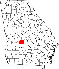 | |
| Towns | ||