Unirea, Alba
| Unirea Vințu de Sus | |
|---|---|
| Commune | |
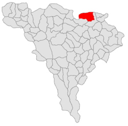 Location of Unirea | |
 Unirea Location of Unirea | |
| Coordinates: 46°24′N 23°49′E / 46.400°N 23.817°ECoordinates: 46°24′N 23°49′E / 46.400°N 23.817°E | |
| Country | Romania |
| County | Alba County |
| Component villages | Ciugudu de Jos, Ciugudu de Sus, Dumbrava, Inoc, Măhăceni, Unirea, Vereșmart |
| Government | |
| • Mayor | Nicoara Aurel (2008) (since 2004) (LP) |
| Area | |
| • Total | 99.99 km2 (38.61 sq mi) |
| Population (2011) | |
| • Total | 4,574 |
| • Density | 46/km2 (120/sq mi) |
| Postal code | 517785 |
Unirea, previously Vințu de Sus (Hungarian: Felvinc, German: Oberwinz), is a commune located in the north-east of Alba County, Romania. It is composed of six villages: Ciugudu de Jos (Alfüged), Ciugudu de Sus (Felfüged), Dumbrava (Dombró), Inoc (Inakfalva), Măhăceni (Aranyosmohács) and Unirea.
Geography
Unirea is located on the Mureş River, in the north-east corner of Alba County, approximately 50 km from the county capital, Alba Iulia, and 20 km from the town of Turda, on the Romanian National Road DN1.
The commune is bordered by Cluj County in the north and west, the town of Ocna Mureş in the east, and the commune of Mirăslău in the south.
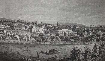
History
From the late 13th century until 1876 the centre of today's commune was the administrative centre of the Aranyosszék region of Transylvania. In 1876, when the administrative system of the Kingdom of Hungary was reorganised, it became part of Torda-Aranyos county.
After the Union of Transylvania with Romania in 1918, the commune became part of Turda County. Since 1968, when the latest administrative organisation in Romania was adopted, Unirea has been part of Alba County.
Name
The first documentary evidence of the commune dates from 1219 under the names Vynch superior, terra Wynchy, Oronos Winch, and Oranas Wincz.
The Romanian version of the name, Vințu de Sus, became official only after the Union of Transylvania with Romania in 1918. Other early Romanian names were Vinț and Felvinț. In 1925, the official name was changed to Unirea referring to the unification of Vințu de Sus and Vereșmart.
The Hungarian version of the name, Felvinc was mentioned for the first time in a document from 1291 in the form Felvynch. As part of the Kingdom of Hungary, the Hungarian version was consistently used throughout the Middle Ages, with the mention that sometimes the form Aranyosvinc and Felső-Vincz were also used. In the 18th and the 19th century, the official name was "Oppidum Felvincz" (from 1760) or "Felvincz mezőváros" (from 1713).[1]
The German version of the name, Oberwintz, dates to 1532.
All the three names are related to each other meaning Upper Vinc/Vințu/Wintz in English. The name refers to the medieval patron of the Catholic parish, Saint Vincentius because a 13th-century document calls the town Sanctus Vincentius.[2]
Demographics
The 2011 census recorded that 4,574 people were living at the time in the commune, of whom 3,233 (70.7%) Romanians, 820 (17.9%) Roma and 514 (11.2%) Hungarians.[3]
Historical population
The historical population of the entire commune as recorded by the official censuses, and projected to the present-day administrative unit, was as follows:[3][4]
| Year | Total | Romanians | Hungarians | Roma |
|---|---|---|---|---|
| 1850 | 4,541 | 69.3% | 23.9% | 6.5% |
| 1880 | 4,636 | 63.0% | 30.2% | n/a |
| 1890 | 5,499 | 62.7% | 31.6% | n/a |
| 1900 | 5,553 | 64.3% | 29.7% | n/a |
| 1910 | 6,234 | 64.6% | 30.4% | n/a |
| 1920 | 5,887 | 71.6% | 27.9% | n/a |
| 1930 | 6,456 | 70.5% | 22.8% | 2.6% |
| 1941 | 6,981 | 78.3% | 19.4% | n/a |
| 1956 | 6,649 | 74.7% | 19.0% | 6.0% |
| 1966 | 6,991 | 80.9% | 17.3% | 1.7% |
| 1977 | 7,089 | 78.1% | 16.9% | 4.9% |
| 1992 | 5,723 | 74.1% | 14.2% | 11.6% |
| 2002 | 5,506 | 74.4% | 12.0% | 13.6% |
| 2011 | 4,574 | 70.7% | 11.2% | 17.9% |
The historical population of Unirea village only (excluding the other 5 villages), as recorded by the official Censuses, was as follows:[4]
| Year | Total | Romanians | Hungarians |
|---|---|---|---|
| 1850 | 1,207 | 1% | 88% |
| 1880 | 1,609 | 8% | 78% |
| 1890 | 1,856 | 7% | 88% |
| 1900 | 1,840 | 6% | 82% |
| 1910 | 2,088 | 9% | 85% |
| 1920 | 1,892 | 14% | 85% |
| 1930 | 2,960 | 45% | 51% |
| 1941 | 3,280 | 58% | 41% |
| 1956 | 3,318 | n/a | n/a |
| 1966 | 3,993 | 67% | 30% |
| 1977 | 4,409 | 67% | 27% |
| 1992 | 3,924 | 65% | 21% |
| 2002 | 3,913 | 67% | 17% |
In 1925 the village of Vereșmart (largely Romanian), formerly considered as a separate village, was united with the village of Vințu de Sus (largely Hungarian), to form the village called Unirea. This resulted in an important increase in population, and a change in the ethnic composition of the village.
Minorities
While the share of the Romanian majority in the territory of the present-day commune has remained almost constant since the mid-19th century (with a slight 5% increase), the two main minorities, the Hungarians and the Roma, have experienced opposite trends. While the percentage of the Hungarian minority almost halved in that time period, the percentage of the Roma minority more than doubled. This resulted in a swap between the Hungarian and the Roma communities as the second and the third most important ethnic groups in Unirea. Numerically, the Hungarian population increased from 1,084 in 1850 to a peak of 1,898 in 1910 and has been gradually declining ever since. The last census of the 20th century recorded 810 Hungarians, which means that their community declined by more than half in 80 years. The number of Roma people increased from 398 in 1930 to 556 (or 14% of the population) in 1992[4]
Unirea village, due to its status as centre of the commune, has been the only village that recorded a population increase since the mid-19th century. Thus, while the population of some of the other villages halved, the total population of Unirea village more than tripled.[4] Because almost all of the Hungarians in the commune (98% of them) were already living in the centre of the commune, this increase in total population, combined with the dwindling numbers of Hungarians, meant that the share of the Hungarian community decreased and the ethnic composition of the Unirea village changed in the 20th century to become more similar with the ethnic composition of the Unirea commune. The last census to record a Hungarian majority in Unirea village was the 1930 census and starting with the 1941 census, a Romanian majority has been recorded.
The village was traditionally the centre of the Székelys of Aranyosszék, a subgroup of the Székelys.
Images
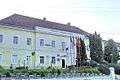 Town hall
 The Orthodox church in Unirea
 View from Unirea
 Ethnographic exhibition in Unirea
References
- ↑ Attila M. Szabó: Historical and Administrative Toponymy of Transylvania, the Banat and Partium. Miercurea-Ciuc, 2003, pp. II/1079-80.
- ↑ "László Vofkori: Travels in Székelyföld. Budapest,1998, Vol I. p. 103"
- 1 2 2011 census data Archived April 18, 2013, at the Wayback Machine., retrieved March 26, 2012
- 1 2 3 4 Varga E. Árpád: Erdély etnikai és felekezeti statisztikája (1850-1992) Retrieved 2007-05-10