University Park, Los Angeles
University Park is a 1.17-square-mile low-income neighborhood in Los Angeles, California, within the South Los Angeles area. It is the site of the University of Southern California, but it is also notable for its dense concentration of residents, their youthful age range, their high ratio of single to married parents, their low rate of marriage and their low median household income. It is one of the most ethnically diverse areas in Los Angeles.[1]

2421 South Figueroa Street
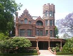
8 Chester Place
625 West Jefferson Boulevard

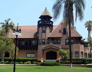
2801 South Hoover Street
The neighborhood has three other institutions of higher learning – Mount St. Mary's College and Hebrew Union College. There are nine lower schools, including one high school. The neighborhood is the home of the Shrine Auditorium.
Population
University Park is one of the most ethnically diverse neighborhoods in Los Angeles, with a diversity index of 0.676. "The diversity index measures the probability that any two residents, chosen at random, would be of different ethnicities. If all residents are of the same ethnic group it's zero. If half are from one group and half from another it's .50."[2]
Latinos made up 47.7% of the population, with whites at 25.5%, Asians at 16.1%, black people at 7%, and others at 3.8%. It is the only neighborhood in South Los Angeles where whites or Asians outnumbered blacks. Mexico and El Salvador were the most common places of birth for the 42.4% of the residents who were born abroad, an average percentage of foreign-born when compared with the city as a whole.[1]
A total of 23,596 people lived in University Park's 1.17 square miles, according to the 2000 U.S. census—averaging 20,217 people per square mile, among the highest population densities in the city as a whole. Population was estimated at 25,181 in 2008. The median age was 23, considered young when compared to the city as a whole. The percentage of residents aged 19 to 34 was among the county's highest.[1]
The $16,533 median household income in 2008 dollars was considered low for the city and county. The percentage of households earning $20,000 or less (56.6%) was the second-largest in Los Angeles County, outplaced only by Downtown Los Angeles. The average household size of 2.7 people was average for the city. Renters occupied 92.2% of the housing units, and homeowners occupied the rest.[1][3]
In 2000 there were 590 families headed by single parents, or 20.3%, a rate that was high for the county and the city. The percentages of never-married women (61.5) and never-married men (67.2) were among the county's highest.[1]
In the same year there were 198 military veterans, or 1% of the population, considered low when compared to the city and county as a whole.[1]
Education
Just 23.7% of University Park residents aged 25 or older had completed a four-year degree in 2000, about average when compared with the city and the county at large, but the percentage of those residents with less than a high school diploma was high for the county. The percentage of the same residents with a master's degree or higher was also high for the county.[1]
The schools within University Park's boundaries are:[4][5]
Post-secondary
- University of Southern California
- Mount St. Mary's College, a private, independent, Catholic liberal arts college, primarily for women
- Hebrew Union College, for training rabbis, cantors, educators and communal workers in Reform Judaism
Secondary and primary
- New Designs Charter School—university park, LAUSD, high school, 12714 South Avalon Boulevard
- Alliance Richard Merkin Middle School, LAUSD charter, 2023 Union Avenue
- Downtown Value School, LAUSD charter elementary, 950 West Washington Boulevard
- Norwood Street Elementary School, LAUSD, 2020 Oak Street
- Star Christian School, private, 2120 Estrella Avenue
- Frank Lanterman School, LAUSD special education, 2328 Saint James Place
- Divine Providence Day Nursery and Kindergarten, private elementary, 2620 Monmouth Avenue
- Saint Vincent Elementary School, private, 2333 South Figueroa Street
- Thirty-Second Street USC Performing Arts, LAUSD alternative, 822 West 32nd Street
Geography
Description
University Park is flanked by Pico-Union on the north, Downtown Los Angeles on the northeast, Historic South Central on the east, the Exposition Park neighborhood on the south and west and Adams-Normandie on the west.[6] The neighborhood's street boundaries are the Santa Monica Freeway on the north, Washington Boulevard on the northeast, Vermont Avenue on the west, the Harbor Freeway on the east, and Exposition Boulevard on the south.[1][4]
Nearby places
Relation of University Park to other places, not necessarily contiguous:[6][4]
 |
Pico-Union | Downtown Los Angeles | | |
| Exposition Park and Adams-Normandie | |
Historic South Central | ||
| ||||
| | ||||
| Exposition Park |
Recreation and parks
- Hoover Recreation Center, 1010 West 25th Street, includes an auditorium equipped with a studio floor and stage, three meeting rooms, kitchen, private outdoor courtyard with children's play area, basketball courts, outdoor fitness equipment, walking/running paths, picnic tables and barbecue pits.[4][7]
- St. James Park, Adams Boulevard and Severance Street, pocket park[4][8]
Facilities
- The Shrine Auditorium, a large-event venue and the headquarters of the Al Malaikah Shrine Temple[4]
- University Village shopping center, West Jefferson Boulevard at Hoover Street. Demolished in 2014.[4]
- California Highway Patrol station beneath the Santa Monica Freeway-Harbor Freeway interchange[4]
Transportation
The Expo Line (Los Angeles Metro) serves the neighborhood, with stations at 23rd Street, Jefferson Blvd./USC, Exposition Park/USC and Exposition Blvd./Vermont Avenue.[9]
Notable residents
- Newell Mathews (ca. 1833–1907) 19th Century businessman and member of the Los Angeles Common Council[10][11]
- Frank Sabichi (1842–1900), attorney, land developer, member of the Common Council[12][13]
- Ygnacio Sepulveda (1842–1916), Superior Court judge, 2639 Monmouth Avenue[14]
References
- 1 2 3 4 5 6 7 8 "University Park," Mapping L.A., Los Angeles Times
- ↑ "Diversity," Mapping L.A., Los Angeles Times
- ↑ "$20,000 or less," Mapping L.A., Los Angeles Times
- 1 2 3 4 5 6 7 8 The Thomas Guide, 2006, page 634 and 674
- ↑ "University Park Schools," Mapping L.A., Los Angeles Times
- 1 2 "South L.A.," Mapping L.A., Los Angeles Times
- ↑ Los Angeles City Department of Recreation and Parks
- ↑ Los Angeles City Department of Recreation and Parks
- ↑ Metro timetable
- ↑ "Dies After Being Rubbed," Los Angeles Times, January 31, 1907, page II-1
- ↑ Location of the Mathews home on Mapping L.A.
- ↑ Location of the Sabichi home on Mapping L.A.
- ↑ "Frank Sabichi Dead," Los Angeles Times, April 13, 1900, page 15
- ↑ Location shown on Mapping L.A.
External links
South Los Angeles region, Los Angeles | ||
|---|---|---|
| Districts and neighborhoods |
|  |
| Points of interest | ||
| Neighboring cities and communities | ||
Coordinates: 34°01′26″N 118°17′02″W / 34.024°N 118.284°W