Upper Historic District (Washington, Massachusetts)
|
Upper Historic District | |
|
The old town hall | |
  | |
| Location | Washington, Massachusetts |
|---|---|
| Coordinates | 42°21′48″N 73°8′37″W / 42.36333°N 73.14361°WCoordinates: 42°21′48″N 73°8′37″W / 42.36333°N 73.14361°W |
| Architect | Unknown |
| Architectural style | Greek Revival, Federal |
| MPS | Washington MRA |
| NRHP Reference # | 86002145[1] |
| Added to NRHP | September 2, 1987 |
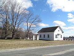
The Upper Historic District is a historic district encompassing the historic center of Washington, Massachusetts on Washington Mountain Road. Located near the summit of Mount Washington, the town center flourished from the town's establishment in the 1750s until the center of the town's business moved closer to the newly lain railroad in the 1830s. The district includes the old town hall, cemetery, common, and pound, as well as a number of residences. A meeting house (church) and schoolhouse once stood in the area, but the 1792 church was destroyed by lightning in 1859, and the schoolhouse is no longer extant.[2]
The district contains Greek Revival and Federal style architecture. It was added to the National Register of Historic Places in 1987.[1]
See also
References
- 1 2 National Park Service (2008-04-15). "National Register Information System". National Register of Historic Places. National Park Service.
- ↑ "NRHP nomination for Upper Historic District". Commonwealth of Massachusetts. Retrieved 2013-12-03.
| Topics |  | ||||||||||||||||||||||||||||||
|---|---|---|---|---|---|---|---|---|---|---|---|---|---|---|---|---|---|---|---|---|---|---|---|---|---|---|---|---|---|---|---|
| Lists by county | |||||||||||||||||||||||||||||||
| Lists by city |
| ||||||||||||||||||||||||||||||
| Other lists | |||||||||||||||||||||||||||||||
| |||||||||||||||||||||||||||||||