Upper Milford Township, Lehigh County, Pennsylvania
| Upper Milford Township | |
| Township | |
| Vera Cruz Tavern, built 1738 | |
| Country | United States |
|---|---|
| State | Pennsylvania |
| County | Lehigh |
| Elevation | 876 ft (267.0 m) |
| Coordinates | 40°31′00″N 75°28′59″W / 40.51667°N 75.48306°WCoordinates: 40°31′00″N 75°28′59″W / 40.51667°N 75.48306°W |
| Area | 17.9 sq mi (46.4 km2) |
| - land | 17.9 sq mi (46 km2) |
| - water | 0.0 sq mi (0 km2), 0% |
| Population | 6,889 (2000) |
| Density | 384.7/sq mi (148.5/km2) |
| Timezone | EST (UTC-5) |
| - summer (DST) | EDT (UTC-4) |
| Area code | 610 and 215 |
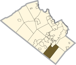
 Location of Upper Milford Township in Lehigh County | |
|
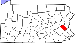
Location of Upper Milford Township in Pennsylvania | |
 Location of Pennsylvania in the United States | |
| Website: http://www.uppermilford.net | |
Upper Milford Township is a township in Lehigh County, Pennsylvania, in the United States. It is a suburb of Allentown, Pennsylvania, in the Lehigh Valley region of the state.
The population of Upper Milford Township was 6,889 at the 2000 census.
Geography
According to the United States Census Bureau, the township has a total area of 17.9 square miles (46.4 km2), all of it land. A large portion of the township is located in the South Mountains, and elevations in the township range from approximately 400 to 1,000 feet above sea level. Upper Milford is in the Delaware watershed and is drained by the Little Lehigh Creek and Saucon Creek into the Lehigh River and by the Perkiomen Creek into the Schuylkill River.
While there are no large towns in the township, its most prominent villages are Old Zionsville, Powder Valley, Shimerville, Vera Cruz, and Zionsville (also in Lower Milford Township.) Dillinger is a small village in eastern Upper Milford and Corning (also in Lower Milford Township) and Sigmund (home to Victory Valley Bible Camp) are small villages in southwestern Upper Milford.
Route 29 and Route 100 meet in Shimerville and continue down Chestnut Street to Hereford just over the Berks County line. Chestnut Street and Kings Highway are north-to-south routes, as are Vera Cruz Road and Powder Valley Road. St. Peters Road/Shimerville Road/Main Road crosses it SW-to-NE and Churchview Road proceeds east from Old Zionsville.
Adjacent municipalities
- Emmaus (north)
- Salisbury Township (north)
- Upper Saucon Township (northeast)
- Lower Milford Township (southeast)
- Upper Hanover Township, Montgomery County (tangent to the south)
- Hereford Township, Berks County (southwest)
- Lower Macungie Township (northwest)
- Macungie (northwest)
Demographics
As of the census[1] of 2000, there were 6,889 people, 2,514 households, and 2,021 families residing in the township. The population density was 384.7 people per square mile (148.5/km2). There were 2,576 housing units at an average density of 143.9/sq mi (55.5/km2). The racial makeup of the township was 98.30% White, 0.16% African American, 0.09% Native American, 0.68% Asian, 0.20% from other races, and 0.57% from two or more races. Hispanic or Latino of any race were 1.02% of the population.
There were 2,514 households, out of which 34.7% had children under the age of 18 living with them, 72.2% were married couples living together, 5.7% had a female householder with no husband present, and 19.6% were non-families. 15.6% of all households were made up of individuals, and 5.3% had someone living alone who was 65 years of age or older. The average household size was 2.74 and the average family size was 3.07.
In the township the population was spread out, with 24.3% under the age of 18, 6.6% from 18 to 24, 28.8% from 25 to 44, 28.0% from 45 to 64, and 12.3% who were 65 years of age or older. The median age was 40 years. For every 100 females there were 102.5 males. For every 100 females age 18 and over, there were 100.7 males.
The median income for a household in the township was $66,694, and the median income for a family was $72,159. Males had a median income of $47,532 versus $29,538 for females. The per capita income for the township was $30,454. About 0.5% of families and 1.3% of the population were below the poverty line, including 1.0% of those under age 18 and none of those age 65 or over.
Politics and government
Upper Milford is represented in Congress by US Representative Charlie Dent in the 15th district and in the State Senate by Bob Mensch in the 24th district. Its Eastern District is represented by Ryan Mackenzie in the 134th district and its Western District by Justin Simmons in the 131st district. All of its legislators are Republican.
Board of Supervisors
- Daniel Mohr, Chairman, Republican
- Rob Sentner, Vice Chairman, Republican
- George DeVault, Democrat
Public education
The Township is served by the East Penn School District. Emmaus High School serves grades nine through 12. Eyer Middle School and Lower Macungie Middle School serve grades six through eight.
References
- ↑ "American FactFinder". United States Census Bureau. Retrieved 2008-01-31.
