Utah State Route 126
| ||||
|---|---|---|---|---|
 | ||||
| Route information | ||||
| Defined by Utah Code §72-4-118 | ||||
| Maintained by UDOT | ||||
| Length: | 21.609 mi[1] (34.776 km) | |||
| Existed: | 1935 as SR-84; renumbered 1977 – present | |||
| Major junctions | ||||
| South end: |
| |||
|
| ||||
| North end: |
| |||
| Highway system | ||||
| ||||

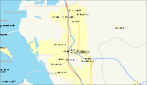
State Route 126 (SR-126) is a highway completely within the Ogden-Clearfield metropolitan area in northern Utah that makes a loop around Interstate 15 in its more than twenty-one mile path. The street is given the names Main Street, 1900 West and 2000 West respectively from south to north. Previous to 1977, SR-126 was a road in southern Utah.[2] A portion of the highway is an old routing of US-91.
Route description
After its southern terminus, the route heads northwest in Layton. After entering Clearfield, the route turns straight to the north. It continues this direction through Sunset, Roy, and West Haven before veering to the northwest when the highway reaches Marriott-Slaterville. The route again reverts to a northerly direction before reaching Farr West. Just before terminating in South Willard, the route turns northwest one final time.
The entirety of the route, with the exception of a small portion from the Interstate 15/Interstate 84 junction to the northern terminus, lies west of the aforementioned interstates.
History
The first iteration of SR-126 was originally created in 1931. This route went from Greenville to SR-21 just west of Beaver. It was deleted from the state route system in 1969.[2]
The portion of what is now numbered SR-126 from the southern terminus to the junction with SR-26 was previously part of US-91.[3] The northern portion of what is now SR-126 was numbered State Route 84 starting in 1953.[4] In 1974, US-91 was eliminated throughout most of Utah,[5] and SR-84 absorbed the portion of former US-91 from Layton to Roy.[4]
The 1977 Utah state route renumbering was implemented, in part, to eliminate instances where a state route used the same number as a U.S. Route or Interstate route in the state. As the 84 designation was also in use for Interstate 84 most of SR-84 was renumbered to SR-126.[4] The only change from then to now was a portion of the old highway that was relinquished to be used by the city of Layton for parking lots in 1991.[2]
Major intersections
| County | Location[6][7] | mi[1] | km | Destinations | Notes |
|---|---|---|---|---|---|
| Davis | Layton | 0.000– 0.164 | 0.000– 0.264 | Southern terminus Northbound exit, southbound entrance | |
| 0.494 | 0.795 | ||||
| 1.591 | 2.560 | ||||
| 3.218 | 5.179 | ||||
| Clearfield | 4.468 | 7.191 | |||
| 5.661 | 9.110 | ||||
| 6.007 | 9.667 | ||||
| Sunset | 7.169 | 11.537 | |||
| Weber | Roy | 8.678 | 13.966 | ||
| 9.073 | 14.602 | ||||
| 11.174 | 17.983 | ||||
| 11.697 | 18.824 | ||||
| West Haven | 13.307 | 21.416 | |||
| Marriott-Slaterville | 14.431 | 23.224 | |||
| Farr West | 18.718 | 30.124 | |||
| Box Elder | South Willard | 21.021– 21.278 | 33.830– 34.244 | ||
| Hot Springs Junction | 21.609 | 34.776 | Northern terminus | ||
| 1.000 mi = 1.609 km; 1.000 km = 0.621 mi | |||||
References
- 1 2 "State Route 126 Highway reference". Utah Department of Transportation.
- 1 2 3 "State Route 126 History". Utah Department of Transportation.
- ↑ Rand McNally Road Atlas (Map). Rand McNally, (hosted by Broer Map Library). 1946. p. 22.
- 1 2 3 "Highway Resolution SR-84". Utah Department of Transportation. Retrieved 2008-05-18.
- ↑ "Highway Resolution route 91". Utah Department of Transportation. Retrieved 2008-03-08.
- ↑ "State Highway Map". Utah Department of Transportation. Retrieved 18 May 2008.
- ↑ "Utah Code -- Title 72 -- Chapter 04 -- Section 118 -- Designation of State Highways Act". Utah State Legislature. Retrieved 2008-08-06.