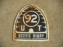
Utah State Route 92
| ||||
|---|---|---|---|---|
| Timpanogos Highway | ||||
| Route information | ||||
| Defined by Utah Code §72-4-115 | ||||
| Maintained by UDOT | ||||
| Length: | 27.272 mi[1] (43.890 km) | |||
| Existed: | 1935 as SR-80; renumbered in 1977 – present | |||
| Major junctions | ||||
| West end: |
| |||
|
| ||||
| East end: |
| |||
| Highway system | ||||
| ||||

State Route 92, also known in various portions as the Timpanogos Highway,[2] and Alpine Loop Scenic Highway is a scenic state highway in Utah County, Utah that runs from I-15/US-89 near Lehi to US-189 in Provo Canyon. The route is approximately 27 miles (43 km) long and is the only road with access to Sundance Ski Resort and the Aspen Grove Family Camp and Conference Center sponsored by the Brigham Young University Alumni Association.
Route description
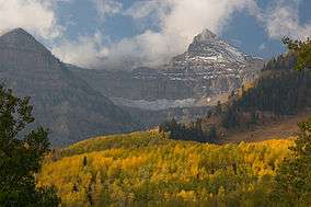
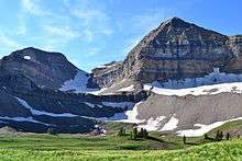
The route runs east from Highland and up American Fork Canyon, where it enters the Uinta National Forest. Shortly after, it passes Timpanogos Cave National Monument, a famous group of caves buried in the side of the canyon. The route continues up the canyon and bends to the south where it passes the east side of Mount Timpanogos. After passing Sundance Ski Resort, the road links up with US-189 in Provo Canyon.[3]
History
The state legislature created State Route 80 in 1935, connecting SR-1 (US-91, now I-15/US-89) near Point of the Mountain with SR-74 south of Alpine.[4] An extension in 1941 took SR-92 east to the Uinta National Forest boundary in American Fork Canyon, replacing a short piece of SR-146 (created in 1933[5]) from SR-74 to the mouth of the canyon.[6] At the other end of the highway, State Route 168 was built in 1933 as a forest road[7] and numbered in 1935, connecting SR-7 (US-189) with Aspen Grove.[8] SR-80 was extended through the forest to SR-7, absorbing SR-168, in 1953. Because the number 80 was needed for I-80, SR-80 was renumbered SR-92 in the 1977 renumbering.[9]
Timpanogos Highway Commuter Lanes
The Timpanogos Highway Commuter Lanes, built from May 2009 to October 2011, are a 3.6-mile grade-separated parallel road of Timpanogos Highway in Lehi with one lane in each direction to bypass signal-controlled intersections.[10][11] The west ramp of the commuter lane is next to the Interstate 15 intersection at N Frontage Road, the east ramp is between Highland Blvd and N Tamarack Drive.[12] The estimated costs were $170 million. [13]
Major intersections
The entire route is in Utah County.
| Location | mi[1] | km | Destinations | Notes | |
|---|---|---|---|---|---|
| Lehi | 0.000 | 0.000 | Thanksgiving Way | Western terminus | |
| 0.069– 0.207 | 0.111– 0.333 | The 7th DDI in the U.S. and the 2nd in Utah[14] | |||
| Lehi | 0.32 | 0.51 | N Frontage Road and Timpanogos Highway Commuter Lane west ramp | ||
| Highland | 3.95 | 6.36 | Timpanogos Highway Commuter Lane east ramp | ||
| Highland | 5.728 | 9.218 | |||
| Cedar Hills | 7.495 | 12.062 | |||
| | 12.596 | 20.271 | |||
| | 27.272 | 43.890 | Eastern terminus | ||
| 1.000 mi = 1.609 km; 1.000 km = 0.621 mi | |||||
References
- 1 2 "Highway Descriptions - State Route 92" (PDF). Utah Department of Transportation. Retrieved 2008-06-24.
- ↑ S.R. 92 will be renamed Timpanogos Highway, Daily Herald (Utah), December 4, 2010
- ↑ Alpine Loop Scenic Byway
- ↑ Utah State Legislature (1935). Chapter 37: Designation of State Roads. Session Laws of Utah.
Route 80. From a point on route 1 near Point of the Mountain east to junction with route 74 near Alpine.
- ↑ Utah State Legislature (1933). Chapter 30. Session Laws of Utah.
(146) From route 1 at Pleasant Grove via mouth of American Fork canyon connect No. 71 below Alpine.
- ↑ Utah State Legislature (1941). Chapter 34. Session Laws of Utah.
Route 80. From a point on route 1 near Point of the Mountain east to the forest boundary in American Fork Canyon.
- ↑ Utah Department of Transportation, Highway Resolutions: "Route 168". (714 KB), updated November 2007, accessed May 2008
- ↑ Utah State Legislature (1935). Chapter 37: Designation of State Roads. Session Laws of Utah.
Route 168. From a point on route 7 in Provo Canyon northerly via Alpine scenic highway to Aspen.
- ↑ Utah Department of Transportation, Highway Resolutions: "Route 80". (20.1 MB), updated November 2007, accessed May 2008
- ↑ UDoT: S.R. 92/Timpanogos Highway, published 7 November 2012
- ↑ UDoT: Commuter Lanes Utah County, accessed 22 December 2013
- ↑ Daniel Avila: SR-92, Lehi to Highland, Roadway Widen, UDoT,
- ↑ Emiley Morgan: UDOT reports 'unprecedented' quality problems with Timpanogos Highway project, Desert News, 8 March 2012
- ↑ University of Maryland, ATTAP: Unconventional Arterial Intersection Design: Diverging diamond interchange, attap.umd.edu, accessed 11 December 2013